Kingsnake's Home Den

Kingsnake's Home Den

Hiking Arizona & Beyond

  • Home
  • Hiking
    • Gear
    • Locations
    • Hikes by Year
      • 2026
      • 2025
      • 2024
      • 2023
      • 2022
      • 2021
      • 2020
      • 2019
      • 2018
      • 2017
      • 2016
      • 2015
      • 2014
      • 2013
      • 2012
      • 2011
  • Creativity
    • Jokes
      • 2016
    • Comics & Memes
    • Poetry
    • Songs & Stories
    • Turd of the Week
      • 1999
      • 2000
      • 2001
      • 2002
  • Military
    • Urgent Fury (Grenada)
      • Invasion!
      • On the Beach
      • Article 15
      • TACCP Stories
      • SFC Frazee’s Photos
    • Gulf War
      • 432nd CA History
      • Letters Home
      • News Articles
      • Gulf War Videos
    • Green Bay to Bosnia
      • McMurry’s Diary
      • Dayton Peace Accord
      • Timeline (1945-1993)
      • Yugo Digest
      • Month in Macedonia
      • News Articles
      • Who’s Who
      • Quotes
    • Decompression Chamber
    • Hohenfels JMRC
    • 153rd Field Artillery
    • War Games
      • B-17: Queen of the Skies
      • Midway
  • Miscellaneous
    • Brew City FA
  • Sitemap
  • Contact

Yavapai County

Not sure what this critter is. I set macro, put my camera near the ground, and hoped for the best!

General Crook Trail: P12-P2

2022-10-06 Hiking 0

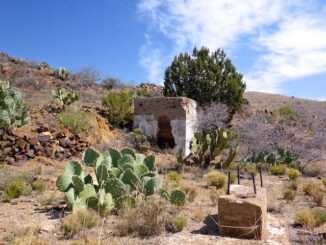
Heading east from Dewey, this is the 2nd segment of General Crook Trail. In 1872, General George Crook — or rather his troops — built a road […]

Ash Creek was this segment's highlight. I was hoping my lunch break at Racetrack Wash would be as verdant.

General Crook Trail: P21-P12

2022-09-07 Hiking 0

Heading east from Dewey, this is the 1st segment of General Crook Trail. I have ongoing projects day hiking / biking the Chesapeake & Ohio Canal, […]

Kingsnake's Dashcam #99: California

Kingsnake’s Dashcam #99: California

2022-08-29 Dashcam 0

Back in Kingsnake’s Dashcam #96, I mentioned that though Phoenix’s bum density was not yet at Los Angeles levels, it was getting there. My most […]

My first decent photo of a Stansbury's cliffrose.

Peavine Trail & Iron King Trail

2022-08-13 Bike Riding 0

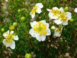
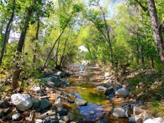
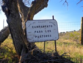
Lots of construction work available in Prescott, so the only day Paul (aka Prescottstyle) had available to do something was on Saturday morning. Paul proposed […]

Kingsnake's Dashcam #97

Kingsnake’s Dashcam #97

2022-06-26 Dashcam 0

I’ve been doing a lot more local driving the last two weeks due to … reasons. Most of it to the area east of downtown […]

Kingsnake's Dashcam 96

Kingsnake’s Dashcam #96

2022-06-01 Dashcam 0

Even back in the 80s, it was obvious Phoenix wanted to be Los Angeles when it grew up. Just, back then, without any freeways. (I-10 […]

The explosives locker at Tri-Metals Mine.

BCT: Brushy Wash to Orme Rd.

2022-04-29 Hiking 0

Of the Black Canyon Trail’s current 93 miles, 16 are located between Big Bug Trailhead and Orme Rd. A steep & rough jeep trail splits […]

Kingsnake's Dashcam #94

Kingsnake’s Dashcam #94

2022-04-29 Dashcam 0

A lot of things I spot while driving, I never click save on. Sometimes when I click save, it is strictly cathartic — not because […]

The chemtrails are stealing our precious bodily fluids!

Toohey Trick Tank Trail #9440

2022-03-31 Hiking 0

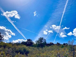
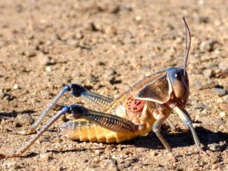
It’s been nine months since Prescottstyle (Paul) and I last hiked together. Now that the weather is better in mile-high Prescott, I figured we ought to […]

Sign near Big Bug Trailhead. I saw no apples.

BCT: Big Bug Creek to Brushy Wash

2022-03-23 Hiking 0

The Black Canyon Trail (BCT) is a National Recreation Trail. Originally 64 miles from Carefree Highway to Big Bug Trailhead on AZ-69, it has grown […]

Posts pagination

« 1 2 3 4 … 15 »

Recent Posts

  • Black Mountain is steep, but not THAT steep.

    Black Mountain

    2026-03-03 Hiking 0
  • North Mountain anti-graffiti sign

    North Mountain Intervals

    2026-02-28 Hiking 0
  • Globe chamomile, aka stinknet (Oncosiphon pilulifer), an invasive species from South Africa, has become widespread in Maricopa County over the last 15 years. Stinknet was the most common flower in Reach 11.

    Reach 11 Recreation Area

    2026-02-25 Hiking 0
  • South Mountain Park: Looking northwest from inside Dobbins Lookout. North Mountain is visible past downtown Phoenix (right).

    South Mountain: Holbert Loop

    2026-02-18 Hiking 0
  • Butterfield Stage Trail: The first Boy Scout skull pole in five miles, at the Happy Camp / Fortymile Desert Tank cistern.

    Butterfield Stage: Estrella Rd. to Gap Well

    2026-02-10 Bike Riding 0

Categories

Archives

Follow us

  • facebook
  • twitter
  • instagram
Follow us
  • facebook
  • twitter
  • instagram

Copyright © 2026 Preston V. McMurry III | WordPress Theme by MH Themes