

It’s been nine months since Prescottstyle (Paul) and I last hiked together. Now that the weather is better in mile-high Prescott, I figured we ought to get together for a hike. I poked around the topo a bit, coming up with Toohey Trick Tank Trail #9440.
The official Prescott National Forest page, says Toohey Trick Tank Trail #9440 is 5.4 miles long, beginning and ending on FR 9267E. It’s actually 7.2 miles. Also, the official route begins on FR 9270K at a private ranch, and ends a 1/2 mile east, across from Old Poley Ranch. Not desiring to intrude, or leave my vehicle vulnerable, I found a better trailhead on FR 9269A. Driving directions below. 🚙
Other possible trailheads are on FR 9407S, near the commo tower, and at the junction of FR 102 and FR 123, at the bottom of Toohey Trick Tank’s access road. I’m not sure where the Tonto Mountain summit trail intersects FR 102.
From the trailhead, continue west, upslope on FR 9269A. Mullen Spring’s metal spring box was dry. The rocky jeep trail climbs 240 ft. in ⅔ mile to Toohey Trick Tank Trail #9440. It feels steeper. The junction is located in a small bowl. Right is a mile to Toohey Trick Tank, but we saved the best for last, turning left to hike the loop clockwise.
After a ½ mile, Toohey Trick Tank Trail #9440 begins descending a spur, opening up a beautiful vista of Granite Mountain, Blair Pass and Little Granite Mountain, five miles east. But! Rather than continue down the road, which eventually intersects FR 9407S near Tonto Mountain Tank #2, instead turn right onto a foot trail. We missed the turn, so I marked it with a new cairn. 🪨
In a ½ mile, Toohey Trick Tank Trail #9440 crosses another foot trail. That is the Tonto Mountain summit trail. We didn’t expect to see another human being all day, but one was there with her dog. She had a German accent, and wished us “Guten Tag!”
The next ½ mile is confusing. Losing Toohey Trick Tank Trail #9440 in a large pile of rocks, we low-crawled a barbed wire fence, then thrashed through abundant catclaw trying to relocate it. Eventually, we found the trail again, as well as the two gates which allow it to cross Tract 43 (a Prescott National Forest inholding) — though we still occasionally got nipped by catclaw. (I have a painful barb buried in my right pointer finger two days later.)
After 2⅓ miles hiking, Toohey Trick Tank Trail #9440 arrives at a saddle on Tonto Mountain’s southwest flank. The foot trail descends 200 ft. in the next mile, eventually becomming old jeep trail. If you look into the canyon to your right, you will see a levee and, on the far side, a windmill. The official end of the trail is in another ½ mile. Instead, aim for the windmill. 🐄
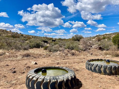
You may have seen cattle, and their poo, here & there along the east half of Toohey Trick Tank Trail #9440, but that is nothing compared to what you will encounter heading up the west half (including two complete skeletons, in various states of decay).
From the windmill, back to the trailhead on FR 9269A, Toohey Trick Tank Trail #9440 is all jeep trail, sometimes smooth, often quite rough. The third gate the trail passes through marks 4 miles, even. A ¼ mile past the gate is Holden Spring. From there, the trail climbs 250 ft. in 1¼ miles. The mountain to your left (west) is Mount Josh.
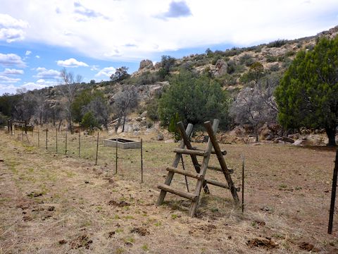
At the top of the climb, is a short side trail to an unnamed tank consisting of rain apron of black plastic sheeting; two large, horizontal, metal tanks; and two tires full of water. From the unnamed tank, Toohey Trick Tank Trail #9440 never varies elevation much until the loop is complete.
After 6½ miles of hiking, Toohey Trick Tank Trail #9440 reaches Tonto Mountain Tank #1. It was about a third full. Just before the tank is an alligator juniper large enough that I marked it on the route below. (Though it’s not nearly as large as the alligator juniper saved by the Granite Mountain Hotshots.)
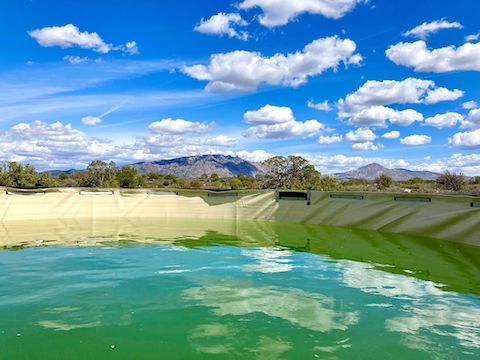
The turn off to the actual Toohey Trick Tank is just 200 yds. past Tonto Mountain Tank #1. Even if you are not into such things, it is well worth a visit. Toohey Trick Tank is an elaborate setup with a wide rain apron of white plastic sheeting, draining to a big pipe, which feeds into a humongous corrugated metal tank, lined with plastic sheeting, and full of water. You could legit swim in it. 🏊🏻♂️
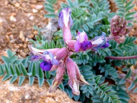
From Toohey Trick Tank, it is just over ¾ mile back to FR 9269A, then back down to the trailhead. Besides abundant catclaw, the terrain is grassy, with plenty of scrub oak, few cactus other than occasional prickly pear & whipple cholla, and enough juniper for sit down — but not hiking — shade. (Toohey Trick Tank Trail #9440 is almost entirely exposed to the sun.)
Besides Toohey Trick Tank, the highlight of this hike are the views: Granite Mountain, Little Granite Mountain, Skull Valley, Peeples Valley, flat-topped Antelope Peak and Yarnell Hill (28 miles south), and even Bill Williams Mountain (46 miles north).
Directions: From Courthouse Square in Prescott, head north on Montezuma St. In a mile, it curves left, becoming Whipple St., which in turn becomes Iron Spring Rd. Between MP 8 and MP 9, turn right onto Contreras Rd., which is smooth, wide, car-drivable dirt. In 2.9 miles, Contreras Rd. curves right to become FR 336. At 4.0 miles, FR 336 ends at a T-intersection. Turn right onto FR 102. At 5.4 miles, turn left onto FR 9269A. Park in 300 yds.
GPS File: Toohey_Trick_Tank_Trail_9440
Distance: 9.68 miles
AEG: 1,369 ft.
Time: 4h 17m
Hike Video
Get to dah choppah!
Seen while hiking west of Prescott with @Prescottstyle two days ago. Not your normal LEO, EMS or civilian model. CH-53? pic.twitter.com/emwFE0mHcd
— Kingsnake (@PrestonMcMurry) April 2, 2022