

The Black Canyon Trail (BCT) is a National Recreation Trail. Originally 64 miles from Carefree Highway to Big Bug Trailhead on AZ-69, it has grown northwards, and is now 93 miles long, ending at AZ-169 (a different road), near Johnson Wash.
Hiking from Big Bug Trailhead is the 12th segment, south-to-north, of the Black Canyon Trail. Options are limited, particularly for completists:
- Big Bug TH to Orme Rd.: A shuttle hike of 15.2 miles, 1,750 ft. accumulated elevation gain (AEG).
- Copper Mountain Loop: Hiking the BCT to the X Lazy B Ranch gate, then looping back on the Copper Mountain Loop is 14.7 miles, 1750 AEG. No shuttle required, but it leaves miles of hard to access Black Canyon Trail uncompleted.
- ✅ Big Bug TH to Old Sycamore Rd.: Hiking halfway to Orme Rd., then out to your shuttle on Old Sycamore Rd. is 9.8 miles, 1060 AEG.
A halfway out & back would be 14.5 miles, 1600 AEG. Having your shuttle pick you up halfway would require 4WD, high clearance, and a fair amount of skill. (The elevation changes at Brushy Wash and Yarber Wash are short, but quite steep.)
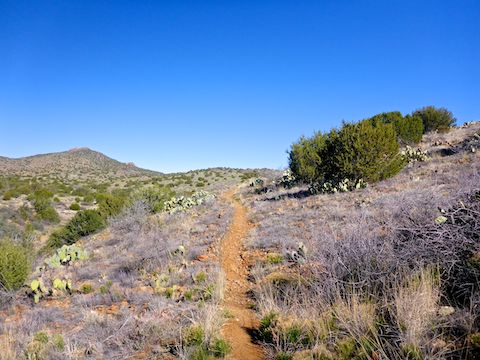
I started hiking at 7:30 a.m. The 12th segment of the Black Canyon Trail heads east out of the Big Bug Trailhead for 200 yds. Just past an old apple orchard / sheep camp, the segment turns left, passing under AZ-69. On the other side of the tunnel is the first of eight gates. The variety of gate solutions is fascinating: Everything from simple saguaro ribs with barbwire loop, to ranch-branded with slant bolts, to elaborate combos of swing gate (for horses) and MTB rollover. 🚵🏻♂️
After the first gate, the Black Canyon Trail climbs 150 ft. in ⅔ mile, alongside some horse properties, to Old Sycamore Rd. The BCT then descends to a wash at the two mile mark. The rest of the hike, both on the BCT, and the jeep trail out to the substation, alternates climbing small ridges, with crossing small washes. The 12th segment is not flat like the Maricopa Trail, but neither is it too difficult.
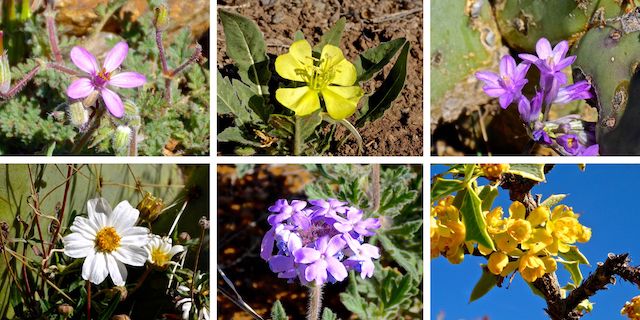
Top Row: redstem stork’s bill, desert evening primrose, blue dick.
Bottom Row: blackfoot daisy, Gooding’s verbena, red barberry.
Redstem stork’s bill were easily the most common flower between Big Bug Trailhead and Brushy Wash, but so small & scattered, I had to pay close attention to the ground to even notice them. Very small blooms; hard to photograph. I also saw a few of the other species shown above, including one dense little patch of Gooding’s verbena. (Check out some other desert flowers!)
At 4⅔ miles, the Black Canyon Trail reaches another unnumbered jeep trail. There is no fiberglass pole sign indicating where on the other side the BCT continues. Turn left, through the green-painted tube gate with the X and sideways B (X Lazy B Ranch) on it, then immediately right, back onto singletrack. The ranch is visible in the canyon below. 🤠
After eating lunch, I looked for a dry way across the Agua Fria River, which is the six mile mark. The river was 2-3″ deep and 10 ft. wide, so I ending up getting one foot wet. (I never got a blister, so it’s all good.) Beating my way through catclaw, on a very old jeep trail, back to the Black Canyon Trail, I crossed an old cement bridge that was still in great shape. It’s marked on the GPS route attached below.
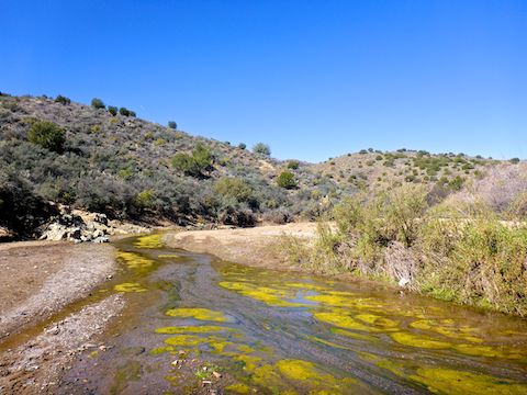
After a short climb up from the Agua Fria River, the Black Canyon Trail crosses two jeep trails, a ¼ mile apart. At the second jeep trail, 7¼ miles into the hike, I turned right. (Continuing on the BCT takes you to Russian Well and, eventually, Orme Rd.) The descent to Brushy Wash was steep and slippery.
The half mile long substation is visible along much of the jeep trail. After crossing another short ridge, the jeep trail descends to Yarber Wash, home to Yarbo Well. The tank was dry, but the two metal boxes were both nearly full. Not sure why it’s called Yarbo Well when it is next to Yarber Wash … 🤔
After a final short ridge climb out of Yarber Wash, the jeep trail follows high tension powerlines to the substation on Old Sycamore Rd. Until I saw my wife at the trailhead, I had not seen another human being all day: Not a mountain biker, dog walker, jogger or horse rider. That’s my kind of hike!
Big Bug Trailhead Directions: From Phoenix, head north on I-17 to Exit 262. There are two exit lanes, on the right hand side of the freeway: Be in the left one, which curls west to become AZ-69. Spring Valley is the little town on the left. 1½ miles past the high school football stadium, keep an eye out for a brown trailhead sign. At the median crossover, turn left into Big Bug Trailhead.
Old Sycamore Rd. Directions: From the Big Bug Trailhead, continue west for ½ mile on AZ-69 to the next right, at the Mayer Fire Department, onto Old Sycamore Rd. It is paved for a few hundred feet, but then becomes quality dirt road. At ¾ mile there is a split, stay left. Early morning sun is brutal, so mind your speed. Also watch out for cattle. When you reach the powerline, turn left along the west side of the substation. Park in back.
GPS File: BCT_Big_Bug_to_Brushy_Wash
Distance: 10.59 mi.
AEG: 1,165 ft.
Time: 3h 48m
Hike Video
Black Canyon Trail: Big Bug Creek to Brushy Wash from Preston McMurry on Vimeo.