Of the Black Canyon Trail’s current 93 miles, 16 are located between Big Bug Trailhead and Orme Rd. A steep & rough jeep trail splits the middle, so rather than doing the long haul, I did the segment in two parts: Big Bug Trailhead to Brushy Wash and, today, from Brushy Wash to Orme Rd.
I had intended to hike my 13th Black Canyon Trail segment a day earlier, but our younger cat Gizmo threw up after dinner on Monday & Tuesday night. So, we stayed home on Wednesday. She seemed well enough to hike on Thursday morning. Then she threw up three times on Friday night and Saturday morning.
Off we rushed to the Blue Pearl Pet Hospital in north Scottsdale, where they found Gizmo had swallowed a linear foreign body, and required emergency surgery. $8,500 — and many hours — later, looks like she’ll make it. It’s a lot of money, but she’s a sweetheart. 😻

As a result, I haven’t had time to type up a full length blog for the Brushy Wash to Orme Rd. BCT segment. I’ll hit the highlights instead:
- To drive from the substation, across Yarber Wash and Brushy Wash, to the Black Canyon Trail, requires high clearance 4×4. (No SUVs, and cerainly no cars!) It’s not far or high, but the final climb to the BCT is quite steep, with a difficult lip.
- The first mile north on the BCT was often indistinct, with catclaw sometimes close to the trail. The next ¾ mile, to the second Brushy Wash crossing, were much better, thanx to the efforts of two trail workers I passed. Thanx trail ladies! 👏
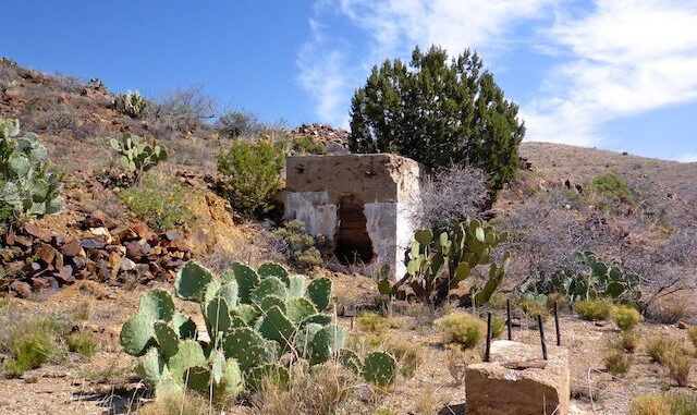
- Russian Well is a neat little area, with the ruins of a stone cabin. Plenty of shade from junipers. No camping is allowed within a ¼ mile due to being a water source for cattle, some of whom were in the corral with very young calves.

- The Tri-Metals Mine tailings are visible from Russian Well. The mine has building and mill foundations, two collapsed shafts, some prospects, and somewhat intact explosives locker. Nothing I could get into, like in my old mine exploring days.
- From Tri-Metals Mine, the Black Canyon Trail parallels a half decent jeep trail over the ridge, under the high-tension powerlines, across Yarber Wash (for the second time), to Orme Rd. On the BCT, it is 4.0 miles; on the jeep trail, only 2.5 miles. Holy hell, those mountain-bike optimized switchbacks got old quick! 😫
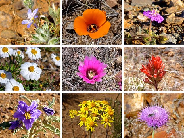
- There was no visible flower coverage — like I could see patches from a distance — but there was a wide variety of species. Besides the ones below, I also photographed rattlesnake weed, lesser yellowthroat gilia, what I think were wirelettuce, chia and vervain. There were at least five other species I did not photograph.

Top Row: desert woollystar, desert mariposa lily, trailing four o’clock.
Middle Row: plains blackfoot daisy, strawberry hedgehog, paintbrush.
Bottom Row: silverleaf nightshade, threadleaf groundsel, New Mexico thistle.
Old Sycamore Rd. Directions: From I-17, take exist 268 west, onto Orme Rd. In ⅓ mile, the road splits. Go left, onto Old Sycamore Rd. The substation is in two miles, turn right, then park in back.
Orme Rd. Directions: From substation, head two miles back to the split. Go left. (Or right, if you just exited I-17.) In 6.7 miles, as you cross a small wash, at FR 68B, park in the camping area.
GPS File: BCT_Brushy_Wash_to_Orme_Rd
Distance: 11.18 mi.
AEG: 1,218 ft.
Time: 4h 01m
Hike Video
Black Canyon Trail: Brushy Wash to Orme Rd. from Preston McMurry on Vimeo.
