

The Prescott Circle Trail (PCT) is a 56-mile, mostly dirt, loop around the city of Prescott — 56 if you count the sidewalk along Williamson Valley Rd. and the roadside dirt of Willow Creek Rd. At some point, I’ll get around to doing the latter. (Sidewalks are for mornings at home.) Instead, today’s objective was to hike what I consider the fifth PCT segment from Turley Trailhead to Goldwater Lake.
The Turley Trailhead to Goldwater Lake PCT segment doesn’t have any decent options for shorter out & back hikes: Though never much more than a mile from paved roads, the intervening terrain is quite rugged. Best to stick to the route and knock out the whole chunk. 💪
After picking up Paul at La Casa Prescottstyle, near Thumb Butte, we got misdirected trying to find Turley Trailhead. Never lost, because being lost requires both not knowing where you are AND not knowing how to get to where you want to be. I knew where we were, but my SUV’s GPS did not show Turley Trailhead. Evenually, we hit the Prescott Circle Trail at 9:25 a.m.
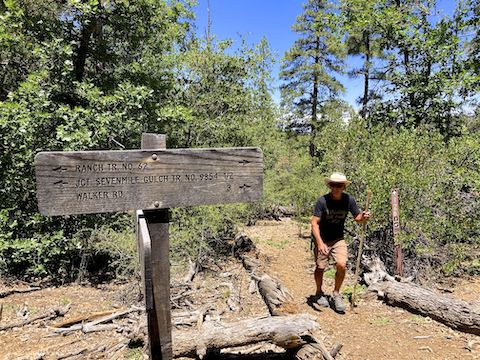
The fifth segment of the Prescott Circle Trail uses all of the unnumbered Turley Trail and Boy Scout Trail #126, part of Ranch Trail #62, and the beginning of Goldwater Lakes Trail #396. We only saw one hiker all day, and that was a guy who rolled up as we were fiddling about Turley Trailhead. No dog walkers, horse riders or trail runners.
We caught up to ther other “hiker” just after passing the AZ-69 split (above). I put that in quotes, because he didn’t seem to be on a mission, nor taking pictures of anything in particular. He wasn’t geared up either, and we never saw him again. Paul sets a pretty good pace. 😅
Exposed & brushy Turley Trail follows the contour for a mile, before dropping 100 ft. to the pine-shaded lower reaches of Government Canyon. There were scads of dense pygmy bluet clusters the next ⅔ mile. Besides the high country flowers seen in this blog, between Turley Trailhead and Goldwater Lake, I also saw silverleaf nightshade, red & yellow pea, Gooding’s verbena, hoary aster and, of course, fleabane.
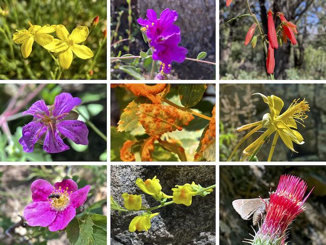
Top Row: rough menodora, Colorado four o’clock, scarlet penstemon.
Middle Row: pineywoods geranium, orange rust, yellow columbine.
Bottom Row: Wood’s rose, Dalmatian toadflax, Arizona thistle.
After two miles, the Prescott Circle Trail turns left off Government Canyon, heading up towards Section 12 Spring. From Turley Trailhead to this point, there were a number of use trails and old jeep trails crisscrossing Turley Trail. Download the attached GPS route so you don’t get misdirected. (Over the course of the day, Paul & I hiked a mile more than the fifth segment’s actual length.)
After just over 2½ miles, Turley Trail arrives at a chain-latched gate, beyond which is the Prescott National Forest. Even before the summer monsoon starts in a few weeks, there was some water in the creek bottom. Beyond the gate, Turley Trail changes designation to Boy Scout Trail #126. 🫡
Despite mosquitoes, the half mile above & below Section 12 Spring are the highlight of the fifth Prescott Circle Trail segment. The Section 12 Spring box was disconnected & dry. I did not spot Section 12 Spring itself, which must be a seep in the small grassy area 200 ft. above the box. An out & back hike from Turley Trailhead to Section 12 Spring would be 6⅓ miles, 1,100 ft. accumulated elevation gain.
The moment Paul & I arrived at Ranch Trail #62 we encountered mountain bikes. (Riding Boy Scout Trail #126 would be rough & technical.) Over the course of an hour, we saw about a half dozen MTBs on the Prescott Circle Trail, then none after. Presumably, they were trying to beat the midday heat. (It was 85℉ when we finished hiking at 2:45 p.m.) All the riders were polite.
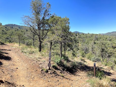
The next half mile was brushy & exposed. The Prescott Circle Trail has been MTB-optimized along most of its length. Since I last hiked Ranch Trail #62 in 2014, the quarter mile south of Ranch Trail #62 has been tripled in length with switchbacks. From the direction we were hiking, it was blocked with brush; at the far end, a carbonite sign. The current, correct, route is attached below. 🧭
From the top of the Ranch Trail #62 reroute, Prescott Circle Trail follows the windy contour along the mostly shady north slope of Hill 6616, Hill 6821 and Hill 6684. I kept Paul amused trying to remember which rock it was where I almost sat on the poopy underwear.
Depending on your location along Ranch Trail #62, there are good views from Bear Down Peak, to the east of Lynx Lake, left past Mingus Mountain to Glassford Hill; or from Sullivan Buttes, on the far side of Chino Valley, left past Granite Mountain to Quartz Mountain and Wolverton Mountain, then Mount Francis. Unfortunately, my iPhone SE does not zoom well. 🤨
It was turning into a long day when Paul & I made the turn south into more sun-exposed brush along the west side of Hill 6684. Thankfully, the Prescott Circle Trail begins descending to the Senator Highway at the 8⅔ mile mark. Having a shuttle waiting there saves a whopping ¾ mile. Instead, we soldiered on.
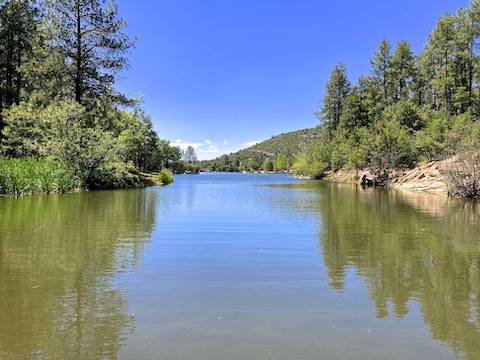
On the west side of Senator Highway, the Prescott Circle Trail becomes Goldwater Lakes Trail #396 — a fast, rolling, MTB track. I would have liked to stop for a rest at Bannon Creek, but my wife was waiting for us up at the Goldwater Lake boat ramp. Imagine my excitement when I saw they sold ice cream! Imagine my disappointment when I realized they are closed during the week …
Turley Trailhead Directions: Access is a bit awkward due to the adjacent AZ-89 and AZ-69 spaghetti intersection. Best bet is to merge onto Gurley St. At the Apache Lodge (on your right), turn left onto Hartin Ave., then left onto Stetson Rd., right onto Robinson Dr. and left onto Butterfield Rd. In 0.8 miles, turn right onto Wells Fargo Rd. In 0.2 miles, at the right bend, on the left is a dirt road. Go down that 250 yds. to the Turley Trailhead.
Goldwater Lake Directions: From Gurley St., near downtown Prescott, turn south on Mount Vernon Ave., better known as the Senator Highway. In 3.0 miles, turn right into the paved Goldwater Lake Park entrance. The entry fee is $3. Parking begins in ⅓ mile at the one-way loop, but if you go halfway around the loop, then make a right and drive another ¼ mile, you will be at the parking spots nearest Goldwater Lake Trail #396.
GPS File: PCT_Turley_Trailhead_to_Goldwater_Lake
Distance: 10.35 miles
AEG: 1,460 ft.
Time: 4h 12m
Hiking Video
Prescott Circle Trail: Turley TH to Goldwater Lake from Preston McMurry on Vimeo.