

On Monday, the Coconino National Forest and Kaibab Forest closed due to extreme wildfire threat. I was planning on hiking around Knoll Lake, on the Mogollon Rim, which is on the border of the Coconino National Forest and Apache-Sitgreaves National Forest. I began looking for something else to do.
On Tuesday, the Apache-Sitgreaves National Forest closed. On Wednesday, the Tonto National Forest closed. I checked the Prescott National Forest site, and they were still open. So, I looked over there. On Thursday, the Prescott National Forest closed. (As well as all BLM and Arizona State Trust land.) The Coronado National Forest, if it is still open, is 4+ hours away. 🚫
Kaibab, Coconino, Apache-Sitgreaves and Prescott National Forests are closed until September 1st. Tonto, which actually has a few low desert rec areas still open, is otherwise closed until October 1st.
Basically, there’s nowhere to hike in Arizona this summer that is under 100℉, unless it is a city park in Flagstaff or Prescott. 😢
I had planned on hiking the Sundog Trail and Badger Mountain Trail portions of the Prescott Circle Trail (PCT) a month ago. I double-checked the route, and it is all outside Prescott National Forest land. I messaged my hiking buddy Paul (aka prescottstyle), and it was on.
The Prescott Circle Trail is a 56-mile loop around the city of Prescott that utilizes City of Prescott, Yavapai County and Prescott National Forest trails. The PCT is a multiuse trail, which means hikers, trail runners, dog walkers, mountain bikers and even horse riders may enjoy it. But not motorized vehicles. ✋
So far, I’ve completed 27 of the Prescott Circle Trail’s 56 miles: From Copper Basin Rd. to Thumb Butte, Thumb Butte to Katahn Rd. and Williamson Valley Rd. to Willow Creek. I don’t dig no road walking, so I skipped the 1½ miles of pavement between Katahn Rd. and Williamson Valley Rd. and the three miles between Willow Creek and Watson Lake.
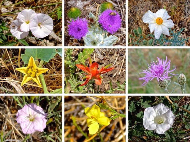
Top Row: field bindweed, Scotch cotton thistle, southwestern prickly poppy.
Middle Row: buffalo gourd, foothill paintbrush, spotted knapweed.
Bottom Row: ???, rough menodora, sacred datura.
Unlike other segments of the Prescott Circle Trail, there are no real options for shorter hikes of the Sundog Trail and Badger Mountain Trail, mainly because there is no trailhead in the middle, where they meet at AZ-69. A Badger Mountain Trail out-and-back to AZ-69 would be 8.3 miles, 860 AEG (accumulated elevation gain), while a Sundog Trail out-and-back to AZ-69 would be a hefty 12.9 miles, 1,210 AEG. It’s exercise, but the payoff at the mid-point is heavy traffic.
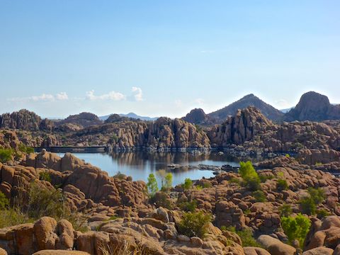
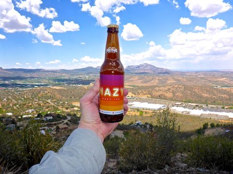
Paul and I started hiking from the Pow Wow Trailhead at 8:30 a.m. It was immediately obvious that Watson Lake was very low. So low, I seriously think I could have walked across it, and gotten less wet than I did on the chest-deep Gila Box River Trail. 🏞
The majority of the flowers on this segment of the Prescott Circle Trail were on Sundog Trail, and most of those between Watson Lake and the old city dump, where I saw beautiful deeply purple thistle. The most common flowers were field bindweed, followed by buffalo gourd, sacred datura, and southwestern prickly poppy.
After a mile, Sundog Trail crosses a pedestrian bridge over Granite Creek. Just past the bridge, turn right before you get on the Peavine Trail. At 1½ miles, Sundog Trail passes under Prescott Lakes Pkwy. At two miles, make a quick left-right to get on the old rail bed. Cross Sundog Ranch Rd. a few hundred yards later, to get on proper single track trail.
The Prescott Circle Trail is optimized for mountain bikes, so there are plenty of switchbacks as Sundog Trail makes three 200 ft. climbs in the next four grassy miles, winding past the old city dump, the juvenile jail, Prescott Lakes Pkwy., and an odd checkerboard area near the Lowe’s Home Improvement, to AZ-69. 🤔
Thankfully, clouds had rolled in, as it was toasty and the only real shade on Sundog Trail was the tunnel under AZ-69. I was disappointed the only graffiti in the tunnel was tags, no elaborate pieces, like under AZ-89 at Copper Creek.
Badger Mountain Trail starts on the south side of the AZ-69 tunnel. It immediately climbs 100 ft. before levelling out for a ½ mile. That is followed by a steady, and of course switchbacked, 400 ft. climb over the next two miles. Like Sundog Trail, it’s still a great trail surface, but the ground cover has changed from grass to shrubbery, such as scrub oak, manzanita and the occasional juniper.
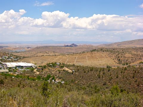
Due to the increased elevation, and lack of overhead cover, Badger Mountain Trail has some of the best views in Prescott. At its high point there is a rest bench. Just past the bench, there is a MTB rollover gate that marks no government boundary I can determine. Certainly not closed Prescott National Forest land. 😇
From the gate, the route is all downhill to Turley Trailhead. In 150 yds., Badger Mountain Trail crosses the summit access road. (It is a ½ mile and 300 AEG to the top.) Two thirds of a mile past that, split right onto the Turley / Badger Connector. (Left stays on Badger Mountain Trail.) Turley Trail is in another ⅓ of a mile: Turn right towards Turley Trailhead — which actually has better views of the white stone “P” than back up on Badger Mountain Trail.
Watson Lake TH Directions: The quickest way is actually to take the beltway around the north side of Prescott. From Phoenix, head north on I-17 to Exit 262. Head west on AZ-69 for 21 miles. Turn right on the Fain Rd. beltway. In 7.2 miles, stay left on the beltway, which becomes AZ-89A. In 6.3 miles, exit south onto AZ-89. (If you’ve spent any amount of time at all in central Arizona, you will know that AZ-89 and AZ-89A are two different highways.) In 3.1 miles, at the traffic circle, go left onto Watson Lake Park Rd. Entry fee is $3.
Turley Trailhead Directions: Access is a bit awkward due to the adjacent AZ-89 and AZ-69 spaghetti intersection. Best bet is to merge onto Gurley St. At the Apache Lodge (on your right), turn left onto Hartin Ave., then left onto Stetson Rd., right onto Robinson Dr. and left onto Butterfield Rd. In 0.8 miles, turn right onto Wells Fargo Rd. In 0.2 miles, at the right bend, on the left is a dirt road. Go down that 250 yds. to the Turley Trailhead.
GPS File: PCT_Watson_Lake_to_Turley_Trailhead
Distance: 10.99 miles
AEG: 1,279 ft.
Time: 4h 03m
Hiking Video
Prescott Circle Trail: Watson Lake to Turley TH from Preston McMurry on Vimeo.