

When I last visited Arnett Canyon and Telegraph Canyon in 2018, I first hiked along the east rim of Arnett. From that vantage point, I spotted what looked like an old jeep trail up the face of the cliff on the west side of the canyon. When I reached the bottom, I couldn’t find the old jeep trail, or any trail other than the official one along the Arnett Canyon bottom.
I’ve hiked through Arnett Canyon and Telegraph canyon at least a half dozen times, including in October, November, and the first and second weeks of December. It seems like around December 10th is usually the best time for fall color. Yes, fall color in the desert! 😯
After breakfast — Spanish omelette with green chili — at Los Hermanos in Superior, I hit the trail at 8:20 a.m. Though 58℉, it was cloudy and felt chilly, so I wore a hoodie.
Perhaps the best fall color was in a grove just past the large boulders blocking further vehicle access. Just beyond the grove, at the first of many dry Arnett Creek crossings, was a carsonite post indicating this was officially now “Arnett Canyon Trail” — not just a foot path — and that the Arizona Trail was ahead.
Ten minutes later I came to a split in the trail. A engraved wood sign announced “↑ Arnett Cyn. Tr. No. 218 … ↑ Jct. L.O.S.T. Tr. No. 221 … ↑ Picketpost TH 4” miles. I was here to explore, so before I went straight on Arnett Canyon Trail #218, I first went left to see what was over that way. In 300 yds., the spur trail ends at FR 4, which has another Arnett Canyon trail sign. The signs were all recent additions. 🐴
Back on Arnett Canyon Trail #218, I passed through the first bolted metal tube gate, then by three new gabions. What the gabions were for, I do not know. Maybe something with horses, since I passed at least a half dozen riders on my way out of Arnett Canyon four hours later. At the junction of Telegraph Canyon, there was another new engraved wood sign. It’s becoming positively civilized down in there!
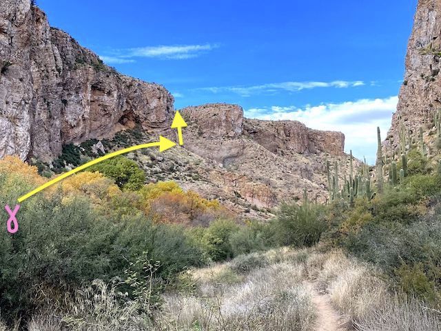
I knew where to cross Arnett Creek, but first I went past the crossing about 150 yds., looking for a distant eye on the climb. (That photo is in my hike video, below.) Though Arnett Creek had some shallow pools, I was able to cross dry, then begin the climb. It was steep — 400 ft. in ⅓ mile (23%) — but short. Other than one 30 ft. section, footing was bueno.
I lost the trail about 50 ft. below the edge of Picketpost Mesa, but by that point it did not matter. The top is rolling, covered in sparse grass, ocotillo, prickly pear, various cholla species, some century plant and barrel cacti, and very few saguaro. The ground surface is slightly rocky, but not really ankle breakers. Being there is a mountain right there, the mesa slopes up to the west. 🌾
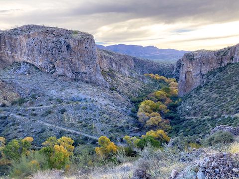
I worked my way counter-clockwise around the mesa’s northeast rim. There were great views of Apache Leap, Superior, its dirt strip airport, the open pit copper mine, Perlite Road, Apache Tears Mine and Boyce Thompson Arboretum. I could even make out the AZ-60 bridge over Queen Creek Canyon. Fall color in Arnett Canyon was moderate. My iPhone had 3-bar Verizon LTE reception.
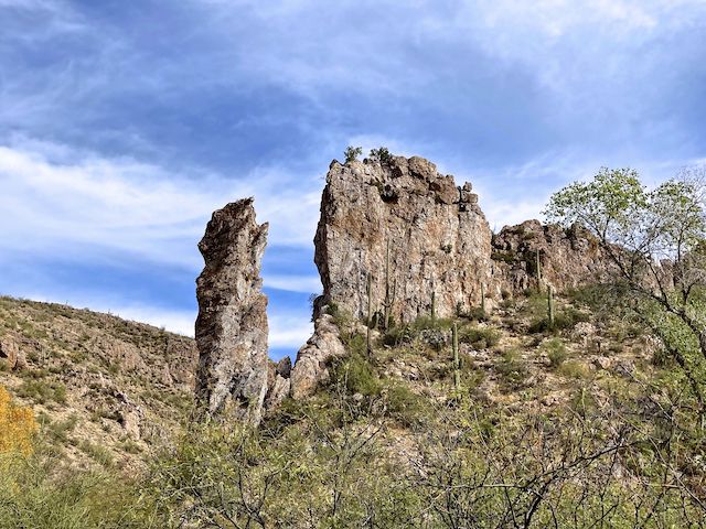
Turning back to the middle of Picketpost Mesa, I spotted a fairly large cairn. I’d heard there were multiple cairns, and more pink tape, on top of the mesa, but otherwise came up empty-handed. I hiked a ½ mile east, but for some reason turned around before reaching the point overlooking Finger Rock. (A spire which marks the junction of Arnett Canyon and Telegraph Canyon.)
To my southwest was a small side canyon of Telegraph Canyon. I could have crossed it, but it looked fairly deep, so instead I followed the elevation contour around the top of it. Turns out it was only 125 ft. deep. 😏
150 yds. later, I came upon a second side canyon. It looked more rugged so, again, to save effort I worked the elevation contour line. I was now close to the bottom of Picketpost Mountain’s summit cliffs, in a couple of acres of pink granite, at the top of a third side canyon. Unless you return the way you came, that pink granite marks the best route down.
Descending the third side canyon, from the pink granite to Telegraph Canyon, is not at all difficult. There is often a path and, when there isn’t, head for the low point. Footing is never an issue. The only problem is catclaw, but if you are paying attention, you can mostly avoid the grab & stabs. If you look out, there’s nice views of White Rock Hill 3012, rock wall-topped Hill 3464, and razor-backed Hill 3595. The only other cairn I bumped into was half way down. It’s a pretty little canyon.
The trail down Telegraph Canyon wasn’t always as obvious as the one in Arnett Canyon, but it was still far better than The Old Days when a fair amount of bushwhacking was involved. At one point, looking down as I do when walking, I glanced up … and jumped. Yikes! Thought it was a critter. Instead, it was just a badger-shaped log. 🦡
Back at Finger Rock, I took a brief break. Afterwards, I booked it back up Arnett Canyon to my car.
A final note about the attached GPS route (below): Normally, it shows the actual trail, rather than my wanderings. Because there is no trail on Picketpost Mesa, this GPS does include my wanderings.
Directions: From Phoenix, head east on US-60, past Gold Canyon and the Boyce Thompson Arboretum. Turn right at Panther Dr., just before the Superior Circle K. In a ½ mile, turn right at the fire department, onto Telegraph Canyon Rd. Just under mile, the road turns to car drivable dirt. At two miles, the road forks three ways. If you have a car, park there, and hike in. Otherwise fork right. The final ⅓ mile is rough, but SUV-able. Going further is blocked by large boulders.
GPS File: Picketpost_Mesa_Explore
Distance: 7.01 mi.
AEG: 880 ft.
Time: 3h 29m
Rumble Video
Vimeo Video
Exploring Picketpost Mountain from Preston McMurry on Vimeo.