

Counter-clockwise from Bronco Trailhead, this is the 20th segment of the Maricopa Trail.
As I work my way counter-clockwise around the Maricopa Trail’s 245 mile loop around the Phoenix metro area, I’ve generally been hiking the more rural — “rural” being used advisedly — trailish bits and biking the sidewalks and canals. (Which comprise about ⅓ of the total distance.) One exception was hiking the Consolidated Canal 7½ miles from Freestone Park to Park of the Canals.
Today’s Maricopa Trail segment was also 7½ miles, from Detroit Coney Grill to Taliesin West. Or, technically, the entrance. Frank Lloyd Wright’s old home is another ¾ mile up Taliesin Dr., the access road. But the Maricopa Trail turns away, there, heading northwest along another canal, the Hayden-Rhodes Aqueduct.
With no obvious trailhead for my always helpful wife / shuttle driver to pick me up at, instead of hiking this Maricopa Trail segment one way, I instead chose to ride it out & back. Fifteen basically flat miles is no problem, especially on high-grip cement suburban multi-use trails. (Cement requires less effort to pedal on, compared to blacktop, let alone dirt hardpack.)
From Detroit Coney Grill, head north to the first intersection, Indian Bend Rd. Cross both roads to get on the catty-corner. Picking up the multi-use trail, Maricopa Trail heads north along the west side of Hayden Rd. You will be following the multi-use trail all the way to Taliesin West. It is divided by a dashed line, just like Hayden Rd. Enjoy the six-lane symphony! 🎻
In ½ mile, Maricopa Trail turns left, onto the north side of McCormick Pkwy. In 250 yds., staying in your multi-use trail lane, turn right along the east side of the McCormick Ranch Golf Club. For the next ½ mile, a massive water hazard will be to your left; townhomes to your right.
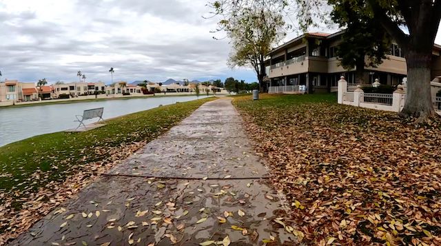
Leaving McCormick Ranch Golf Club behind, Maricopa Trail travels under Via de Ventura — the first of ten large flood control tunnels in the next three miles. On the north side of the tunnel, Maricopa Trail separates Marguerite Lake from more townhomes. Marguerite Lake is a small artificial lake that allows fishing, kayaking, etc. There’s plenty of waterfowl: I spotted geese, ducks & coots. 🦆
If you are in the middle a longer ride, at the 2-mile mark, there are several restaurants. Turning left at the Phoenix Beer Company, Maricopa Trail again follows the west side of of Hayden Rd. At the north end of Marguerite Lake, Maricopa Trail turns northeast, under Hayden Rd.
I’d had to pee since we arrived at Detroit Coney Grill, so when I saw a sign ahead for Mountain View Park, I was hopeful it would be one with a restroom. All along the multi-use trail there is a steady stream of walkers, joggers, dogs and bicycles, so no opportunities for a trailside pee that would not involve a registry. Thankfully, 200 yds. up the side path, Mountain View Park has a nice, bum-free, restroom.
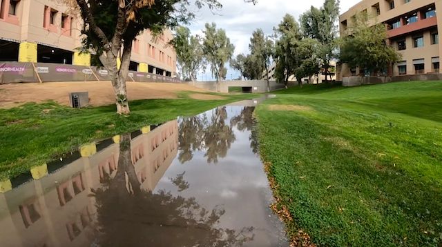
At 3¼ miles, Maricopa Trail passes under Loop 101 Pima Freeway. I spotted no graffiti in that tunnel, or any other. Just white & tan splotches where the Scottsdale had quickly dealt with the situation. The Scottsdale Greenbelt narrows as it passes below an commercial / office area, approaching the hospital at 90th St. and Shea Blvd. Water accumulates there, but there was only an inch when I rode through. 💪
The deepest tunnel, under Shea Blvd. at 4¼ miles, actually had almost no water, despite being used for flood control. Unlike Sunnyslope, also no bums. The Maricopa Trail quickly curls behind some more restaurants, then passes under 92nd. St. The multi-use trail crosses the entrance to Paradise Memorial Gardens, but no worries: No one is leaving.
At 5 miles, now out of the drainage, Maricopa Trail does a quick right-left across Cholla St. The multi-use trail parallels 94th Way for a half mile to Cactus Rd. There, the trail splits: I went left, then turned right, onto the bike lane along the south side of Cactus Rd. If you instead split right, and under the road, then curl up & right, you will be following the multi-use trail along the north side of Cactus Rd.
I thought Cactus Rd. would have less traffic, but despite several traffic circles, it was steady. Watch out for Phoenix asshole drivers: I saw one car pass in the turn lane, and a yard crew swerved into the bike lane just ahead of me. Take the multi-use trail instead. On my return trip, I rode the horse path that is also on the south side of Cactus Rd.
Despite fighting 15 mph headwinds the whole way, I arrived at Taliesin West in only 55 minutes total time. On my return trip, with the slight downhill and no headwind, I rode three gears higher, and it somehow still took me 55 minutes moving time (i.e., not counting photo stops). I dunno. 🤷🏻♂️
I’ve now completed 193.13 miles of the Maricopa Trail.
The best part of doing a winter locals hike — or in this case, ride — is that I often get home before dark and can begin doing my post-hike work: Writing the blog, editing the GPS route, weeding through & color correcting the photos, creating the video, selecting the music for the video (which often takes the most time), writing the metadata, and uploading the results to multiple websites. Whew!
Detroit Coney Grill: Southeast corner of Hayden Rd. and Indian Bend Rd.
Taliesin West: There’s a spot on the northeast corner of Taliesin Dr. and Frank Lloyd Wright Blvd. where someone could drop you off real quick, or pull over to pick you up, but it’s not for parking.
GPS File: Maricopa_Trail_Detroit_Coney_to_Taliesin_West
Distance: 15.49 mi.
AEG: 292 ft.
Time: 1h 50m
Rumble Video
Vimeo Video
Maricopa Trail: Detroit Coney Grill to Taliesin West from Preston McMurry on Vimeo.