

Rim Rd. / FR 300 — the artery of the Mogollon Rim — is closed for five or six months a year, during the winter. Seems like once a winter some bozo wanders off pavement in deep snow and is found a week later, starved and half-frozen to death. Rim country opened up a few weeks ago, even though being federal land in the Apache-Sitgreaves National Forest the campgrounds and other facilities remain closed due to the coronavirus panic. (Arizona state campgrounds are open.) 🦠
I’ve been itching to get back up to the Mogollon Rim, and resume my quest to hike every one of its named canyons. The last one was Turkey Creek, on the east flank of Gentry Ridge.
So, this week, I decided to hike Open Draw, one canyon over, on the west side of Gentry Ridge. I looked at making a loop of it with Gentry Canyon, which is west of Open Draw, and looks relatively open, but decided in the end to follow my pattern of canyon crawling out, then taking forest roads back. The distance is the same, but what appears easy on the Mogollon Rim, could turn into a Crackerbox Canyon, and I did not want to face doing that upslope.
Open Draw is a short, shallow, canyon extending 3.6 miles from the intersection of FR 91 and FR 40F to Gentry Canyon. Like Turkey Creek and Beaver Canyon, just a mile or two east, Open Draw is a mostly mellow stroll. Your Open Draw hiking options are:
- What I did: Hike to the end of Open Draw, bushwhack out, then take forest roads back to the trailhead (9.9 miles, 560 AEG).
- Hike Open Draw to FR 40, cut through Camp Bonito to FR 40F, then take forest roads back to the trailhead. This is abbreviated version of my loop, without any deadfall (7.2 miles, 360 AEG).
- Hike Open Draw to FR 40, head 50 ft. to your left, then immediately turn right onto FR 40G, which looks like a grassy shelf. Follow FR 40G counter-clockwise 2.6 miles until it reconnects to FR 40 on the opposite side of the “clock”, then take forest roads back to the trailhead. This is a deadfall free, mostly low traffic, version of my loop (10.0 miles, 530 AEG).
- Hike Open Draw to Gentry Canyon, then take Gentry Canyon back to the trailhead. Gentry Canyon looks unobstructed on satellite, but conditions on the ground can always vary (10.2 miles, 630 AEG).
- Hike Open Draw to FR 40, then head back the way you came. Scenic, short & mostly off road (6.8 miles, 400 AEG).
You can chop 2.8 miles round trip off the distances of options 1-4 by parking at the FR 91 intersection with FR 40F. We made the drive from Sunnyslope to Rim Rd. / FR 300 in only 1h 54m. The drive back would be much more eventful.
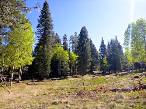
I started hiking north on FR 91 at 8:30 a.m. There was no traffic yet at that hour, and only one RV camping along the road. In 1.3 miles, at the intersection of FR 40F (left) and FR 91 (right), I split the difference, heading off trail between two pine trees. (You can see the pines in my hike video, below.) That is the head of Open Draw. I simply followed the low ground for the next 3.7 miles to Open Draw’s mouth at Gentry Canyon. 🧭
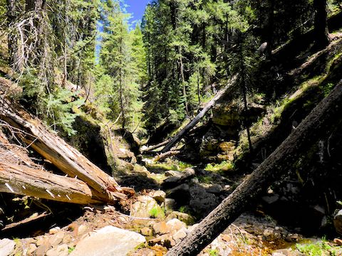
There was a bit of minor deadfall on the way down, but after that Open Draw was smooth sailing along grassy creekside shelves. (The “creek” at first dry, then with small spot puddles.) I saw a few flowers too small to photograph, but 90% of the blooms were dandelions. Some people call them “weeds”, but I think dandelions are pretty.
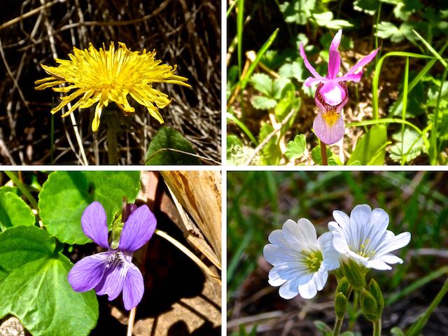
The only other flower I saw in any quantity were pine thermopsis, a member of the pea family also known as golden pea. I saw pine thermopsis here & there in Open Draw, but there were several large, dense patches along FR 40F.
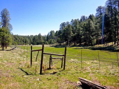
1.4 miles down Open Draw, I entered a narrow, ¾-mile long, prairie. I found a 15’x15′ area with a totally collapsed fence around it. Just beyond that is a much larger fenced area, 66 paces wide at the base, by 386 paces long. Call it the “wetlands”. ⛔️
The fence around the wetlands is still somewhat intact and was once electrified. (What looks like a sign in the middle, is actually an old junction box.) At least part of the wetlands had a shorter inner fence. There is a rusted metal trough near the narrower north end of the wetlands. The water course, spreads out in the wetlands, seeping across the soaked surface, rather than flowing like a creek. A very old jeep trail runs from the north side of the fence to FR 40. There are two 3’x3′ fenced areas beside the jeep trail: I’m not sure what they are for either.
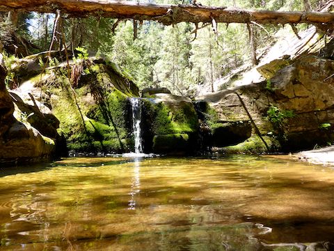
From the prairie / wetlands, I crossed FR 40 for the first time. On the north side of FR 40, there is a very small check dam, no more than a cement curb, and many white rocks, presumably to control erosion. Past the check dam, Open Draw begins tightening up, becomming deeper, steeper, with more deadfall and pools. There were several small 6-24″ pours, but no major obstacle of any sort. The thickest part of Open Draw is, as is to be expected, the final half-mile north to Gentry Canyon, but no massive logs to be low crawled. Slow going, but not bad.
Rather than eat lunch where Open Draw empties into Gentry Canyon, I instead took an animal trail 250 ft. up the bluff to the north end of FR 40E. I crossed a meadow, and FR 40G, about halfway up.
There were a number of very old, abandoned, log decks along FR 40E. It has been so long since the road has seen vehicles, that FR 40E is covered with a half inch of pine needles. Fire appears not to have touched Open Draw, or the forest roads on this hike, so there was plenty of shade.
At FR 40, I turned left for 4/10s of a mile. Just before Camp Bonito, I split right onto FR 40F. Besides the pine thermopsis, FR 40F had a really nice grove of quaking aspen.
Back at the split where I first descended into Open Draw, I rejoined FR 91, which by nearly 2 p.m. had regular traffic, including pickups, RVs and a parade of ATVs. (Thankfully driving responsibly.)
On the way from the trailhead back to AZ-260, we were passed, a minute apart, by Coconino County Sheriff’s pickup, a fire department pickup, then two ambulances — all code 2. As interesting as that was, it was WAAAAY topped by the incident on AZ-87 near Sunflower: We saw smoke from a distance, but when we got closer, it was a car fully engulfed by fire! 🚙🔥

Directions: Head north on AZ-87, the Beeline Highway, into Payson. Turn right on AZ-260. In 29 miles, after cresting the Mogollon Rim, take the first left onto FR 300 / Rim Rd. In 3.2 miles, at the Woods Canyon Lake intersection, Rim Rd. turns to car-drivable dirt. 9.4 miles from AZ-260 is a t-intersection. Turn left. (Right is FR 34 to Winslow.) In 7.1 miles, turn right onto FR 115, aka Limestone Rd. In 1.2 miles, turn right onto FR 91. In a ¼ mile, park in the clearing on the right.
GPS File: Open_Draw_Mogollon_Rim
Distance: 11.18 miles
AEG: 653 ft.
Time: 4h 13m
Hiking Video
Hiking Open & Draw, Mogollon Rim from Preston McMurry on Vimeo.