

I don’t get out to the Sierra Ancha too often, as it is a three hour drive from Sunnyslope, despite being only 67 miles away as the crow flies. Or hawk, as I would later discover.
More so than any other mountain range or wilderness in Arizona — other than deep inside the Grand Canyon — the Sierra Ancha has no paved access. (Unless you count the Young Highway / AZ-288, which is dirt much of the way, including at Juniper Flat.) For instance, to access the bottom of Cherry Creek, FR 203 requires 4WD and high clearance. As a result, many Sierra Ancha hikes involve significant elevation change, long distances, or both. 😒
So, it took me awhile to come up with a relatively mild hike, that my Acura RDX AWD could easily access: Juniper Flat, which is at the base of McFadden Peak. I used the same trailhead / campsite as I did for Elephant Rock Arch; parking at Juniper Flat Tank is another option.
Exploring Juniper Flat is a total, but mild, bushwhack. Unless you’re comfortable with terrain association, or simply winging it, you should carry a GPS or a map & compass. I’d say “It’s difficult to get lost”, but then some bozo managed to wander off one of the most heavily trafficked trails in the United States — the Appalachian Trail — and subsequently starve to death. 🙄
Suffice to say that Juniper Flat is roughly bounded by the Young Highway / AZ-288 on the west, Elephant Rock to the south, the Cherry Creek rim to the east and the pass at Turkey Spring to the north. You are never lost unless you both don’t know where you are and don’t know how to get to where you want to be. If you don’t know where you are, and don’t know how to proceed, head west until you hit a major dirt road — it’s AZ-288 — then flag someone down. (There’s no cell reception on Juniper Flat.) 🧭
The plan I loaded onto my crappy Garmin 62S, involved hiking a figure 8 of Juniper Flat, with Juniper Flat tank at its middle. I expected the hike to be about 9.5 miles with minimal accumulated elevation gain (AEG).
Instead, I ended up only hiking the southern half of my Juniper Flat figure 8, and still accumulated 8.3 miles.
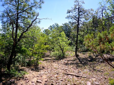
There’s a fence at the trailhead, and if you follow it east away from Young Highway / AZ-288, there is a gap in it, rather than a gate. (I used one of the fence posts as a “tripod” to film the intro to my hike video.) I started my Juniper Flat exploration by hiking through the gap. I headed northeast, making sure to stay on the Juniper Flat side of the unnamed canyon that separates it from Elephant Rock Mesa.
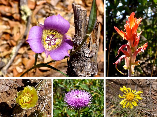
Juniper Flat has quite a bit of vegetation, mostly pine, pinyon, juniper, manzanita, etc. No catclaw that I recall. The few cacti were mostly prickly pear, which had some amazing flowers. Fleabane and some yellow flower I can never remember the name of were quite common. The manzanita were blooming their tight clusters of white & pink flowers. I also found New Mexico thistle, indian paintbrush, ocotillo, and an absolutely stunning purple number that I believe was a Gunnison’s Mariposa Lily.
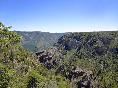
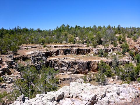
Besides simply enjoying the day, my main objective was to see if there was a way down to the mines / caves, I had previously spotted from Elephant Rock Mesa. They were on the Juniper Flat side of the canyon, maybe 200 ft. down from the rim. When I got near to where they should be, I would get closer to the edge, peer around, move over a bit, repeat, etc. There were some cracks in the rim that I could have scrambled down to about the right level, but didn’t want to waste the energy if I didn’t see the caves first. It might be a small, unnamed, canyon, but it is sheer & rugged.
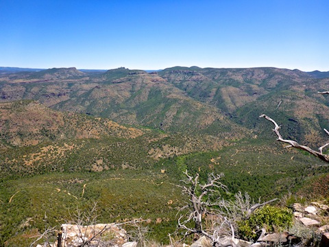
Moving along the rim of the unnamed canyon, and Cherry Creek into which it feeds, had both the most tangled vegetation on Juniper Flat, and also the most open movement. Where it was tangled, I would “dip in & out” from the rim, as I sought a less tangled path — which is why the attached GPS route looks so jagged. Where the rim was clear, it was smooth sailing across flat stone outcroppings. 🏃🏻♂️
Juniper Flat has much less wildfire damage than Elephant Rock Mesa, so there is plenty of shade. Still, I got quite sunburned from spending so much time on the exposed rim of Cherry Creek.
3.0 miles into my explore, I found two cairns about 25 yds. apart: one regular size, one with large stones. I couldn’t figure out their purpose, nor that of an obviously placed wood pole at the 3.4 mile mark. The wilderness boundary was nearby, so maybe that is why? 🤔
A ¼ mile west of the wood post is a beautiful, layered, dryfall that would be spectacular if water was running. As I had already been exploring three hours, I decided to skip the northern half of my planned Juniper Flat figure 8.
I knew there was a dirt road near the dryfall, so I hopped on that, hiking its entire 1.4 mile length to the Young Highway / AZ-288. I stopped about midway for a 20-minute lunch break.
The first 3.5 miles of my Juniper Flat exploration were in the Sierra Ancha Wilderness. I crossed the wilderness boundary two other times, and approached it a third, but never saw a fence of any sort, other than by the trailhead, and along the Young Highway / AZ-288. There is no fence along the Cherry Creek rim, nor where the dirt road crossed the wilderness boundary. (It ends in a loop a ¼ mile into the wilderness.) With no barrier, it was no surprise to see an OHV exploring the dirt road.
After walking the dirt road’s length, I again headed off trail, searching for Juniper Flat Tank — which is not where the map claims it is. I did, however, find a land survey monument and the cadastral survey marker for the northeast corner of the Cagle Cabin admin site.
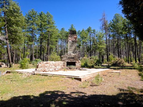
What I assume is Juniper Flat Tank, was 200 yds. away. It was a large, waterless, clearing with two large water bladders, wood benches, an upright metal tank, a small metal tank on a trailer, and an old home site with two concrete foundations, a stone grill / BBQ pit, and a mostly intact stone chimney. From Juniper Flat Tank, it was under a mile back to the trailhead.
On our way home, my wife & I stopped at Big Daddy’s Pizza in Tonto Basin, which appears to have weathered the coronavirus panic, and even extended their closing to 7pm. I was worried, as Big Daddy’s has been for sale for several years. Despite being a regular pizza, Big Daddy’s piles so many ingredients on that it is more like a deep dish. As usual, I could only eat two of their piled high slices, washed down with a pair of ice cold Miller Lites — which might not be a proper hiking beer, but it’s a good thirst quencher. Think of Miller Lite as flavored water, or adult Kool-Aid.
Directions: Depending on where you live in the Valley, there are two general ways to get to the Sierra Ancha: From the south & east Valley, take US-60 to Globe, then AZ-188 north towards Roosevelt Lake. From other parts of the Valley, exit the Loop 101 at Shea. Go east on Shea to the Beeline Highway (AZ-87). Go north on the Beeline Highway for 46 miles to AZ-188. Go east on AZ-188 for 46 miles, passing through the small communities of Jake’s Corner, Punkin Center, Tonto Basin and Roosevelt. Turn north onto the Young Highway (AZ-288). The road is narrow & twisty as it climbs into the Sierra Ancha, so mind your speed. In ~22 miles, as AZ-288 crests the climb, it turns to car drivable dirt. In ~9 more miles, just past FR 561 to the McFadden Lookout, on the right will be a pullout. Park there. You’ll need an SUV to cross the shallow ditch at the edge of the road.
GPS File: Juniper_Flat_Sierra_Ancha
Distance: 8.32 mi.
AEG: 629 ft.
Time: 4h 14m
Hiking Video
Hiking Juniper Flat in Sierra Ancha from Preston McMurry on Vimeo.