

Counter-clockwise from Bronco Trailhead, this is the 23rd segment of the Maricopa Trail.
Not doing my planned South Mountain hike last week gave me time to work on my Sunnyslope Murder Tour project, do some extra bike miles to prepare for today, and do a short recon hike along a few of today’s trails.
Today’s segment from Tom’s Thumb Trailhead to Granite Mountain Trailhead, via Fraesfield Trailhead, comprises mile 211-221 of the Maricopa Trail, a 245-mile loop around the massive Phoenix metro area. The official route loops out on Pemberton Trail, but like I explained a few weeks ago, I’ve already done that bit multiple times. Still, I’ve included it in the GPS file attached below.
Out & back, from either Tom’s Thumb Trailhead or Granite Mountain Trailhead is 19.8 miles, 1,100 ft. AEG (accumulated elevation gain). I’m not a strong mountain biker, so I did it with a shuttle, one way, south-to-north.
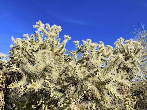
From Tom’s Thumb Tailhead, it is a fast downhill, through big cholla, on Marcus Landslide Trail and Rock Knob Trail. Watch out for pedestrians. I saw a skidmark where one MTB almost hit a cholla. 😬
I turned left on Gooseneck Trail at the Diamond Fire burn area sign. If you miss it, keep heading out to Pemberton Trail, then connect back up to Gooseneck via Jackass Junction.
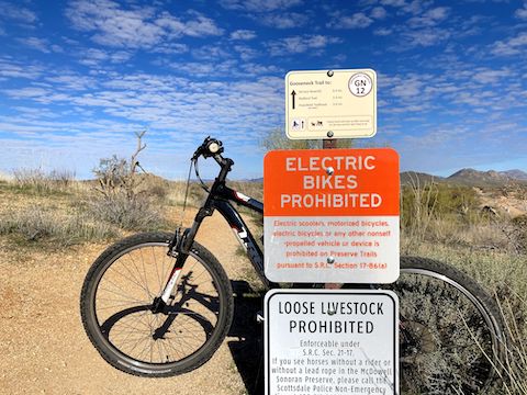
Also, if you want to ride a motorcycle, stay on the street. 👋
Gooseneck Trail was mostly smooth hard pack, with a covering of pea gravel. Occasionally, it had granite chunks or rocks. Gooseneck Trail was off camber near the housing. It was very twisty, with quick flow (especially northbound). The washes were narrow, and easily crossed, as the sand was mostly pushed aside by previous bikes. Few MTBs (mostly southbound); not many pedestrians.
After the ¼ mile “county connector” to Jackass Junction, Gooseneck Trail turns west into the Diamond Fire burn area. The trail is off camber as it climbs out of a wash, but soon levels out as it passes by an unnamed tank, near the fire’s ignition point, on the north side of the $1.7 million+ Storyrock development. By the time you cross 128th St., you are out of the burn area.
After crossing 128th St. at the 4¼ mile mark, Gooseneck Trail turns north, getting even zippier. One place you definitely need to zip is crossing very busy Rio Verde Dr. at 6½ miles: There’s neither a tunnel nor crosswalk. Gooseneck Trail ends at Fraesfield Trailhead. It’s a web of singletrack and old jeep trail. Follow the signs, picking up Black Hills Trail on the north side of the restroom building.
Black Hills Trail is an old jeep trail, with a few short singletrack sections. Lots of pedestrians, even on a week day. After the only other slight climb of the day, I turned right onto Turpentine Trail, just past the 9-mile mark.
Though not forested, singletrack Turpentine Trail was the greenest part of the 23rd Maricopa Trail segment. I finished it in 1h 28m. Unfortunately, my chest-mounted GoPro was angled too low. Mostly knees and handlebars. So, I get to go back and do it again next week! 😆
2024-02-06 Update: Back out to do it again, with better camera angles. Totally different weather: 10° warmer, supposedly, but totally overcast, plus breezy. Anyway, made fewer mistakes, stopped less often, and finished seven minutes faster. 💪
I’ve now completed 220.76 miles of Maricopa Trail. Two more segments to go!
Tom’s Thumb Trailhead: From Loop 101 / Pima Freeway, take exit 36 north onto Pima Rd. In 4.8 miles, turn right onto Happy Valley Rd. In 4.3 miles, turn right onto Ranch Gate Rd. In 1.3 miles, turn right onto 128th St. The Tom’s Thumb Trailhead is in 1.4 miles, just past the traffic circle.
Granite Mountain Trailhead: From Tom’s Thumb TH, head north on 128th St. for 3.0 miles. (It is smooth dirt part of the way.) Turn right on Rio Verde Rd. In 1.0 mile, turn left on 136th St. In 2.0 miles, turn left into the trailhead.
Park Map: McDowell Sonoran Preserve North Area Map
GPS File: Maricopa_Trail_Toms_Thumb_TH_to_Granite_Mountain_TH
Distance: 9.91 mi.
AEG: 440 ft.
Time: 1h 28m
Rumble Video
Vimeo Video
Maricopa Trail: Tom’s Thumb TH to Granite Mountain TH from Preston McMurry on Vimeo.