
 south of Desert Hills Trailhead.")
Three years ago, I hiked the other “half” of Ocotillo Trail and Sidewider Trail, from Apache Wash Trailhead, at the east end of the Phoenix Sonoran Preserve. Today, I hiked the western half of Ocotillo Trail and Sidewider Trail, with no extras. At only 5¼ miles, 580 ft. AEG (accumulated elevation gain), this loop is what I refer to as a locals hike.
Desert Hills Trailhead is located on the southwest corner of Carefree Highway and 7th Ave. There’s a ton of parking spaces, plus a horse trailer lot. There are his & hers flush bathrooms, but no potable water. It has the usual array of trail maps and nature info signs.
The most interesting feature of Desert Hills Trailhead — which I didn’t notice until I returned — were the rusty iron cholla skeleton latticework shading the cabana. (See the video thumbnail, below.) I was too busy checking out the giant fan. I’ve never seen a fan at a trailhead before.
Starting on Ocotillo Trail, I hiked counter-clockwise so I would not be “chasing” the sun: Rather than fighting glare, the sun would be mostly quartering my photos, giving them shadowy depth. Or would with a better camera than a second generation iPhone SE. (I lost my Panasonic Lumix DMC-TS5 in a canal last year.)
The western portion of Ocotillo Trail is rockier than it’s eastern half. It’s okay for hiking, but would be bumpy riding. Views are decent: Construction on the TSMC chip fab is finally back underway. A mile in, Ocotillo Trail drops 200 ft. in a half mile, which would be a grind if you pedalling the opposite direction.
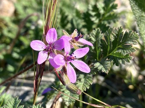
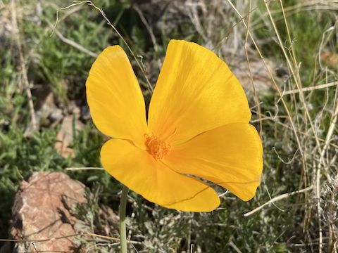
Phoenix has had a pretty good winter monsoon, but the night’s are still chilly, so I wasn’t expecting any flowers at all. While today did not rise to the level of #flowerporn, it was a pleasant surprise: Besides the pictured species, I also spotted creosote (Larrea tridentata) and brittlebush (Encelia farinosa). The Ocotillo Trail’s namesake are lagging. There was grass in the many wash crossings.
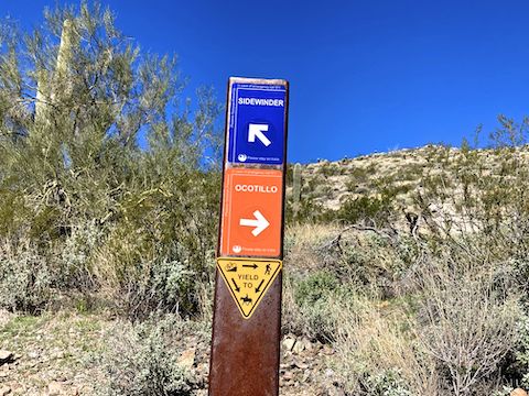
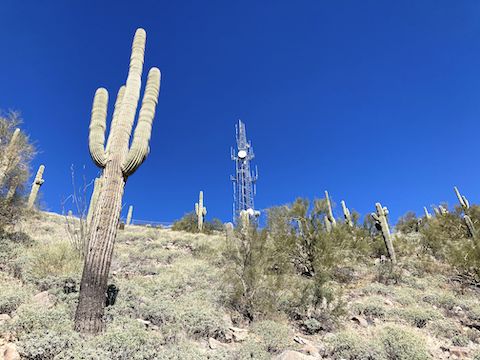
After 2¾ miles, Ocotillo Trail climbs 75 ft. in a quarter mile to it’s intersection with Sidewinder Trail. Sidewinder Trail turns back to the north & west, climbing another 200 ft. in the next 1⅓ miles to just below the summit of antenna hill / Hill 2158.
Sidewinder Trail wraps around the upper reaches of two large washes. At the top of the first, there was new home construction going on. At the top of the second, there is a 50 yd. connector to the paved antenna access road (7th Ave.) That’s where the only real shade of this loop was located.
From the shady spot, Sidewinder Trail was a quick mile downhill back to Desert Hills Trailead. It wasn’t a destination hike, so I was done by lunch time, picking up my kind of hiking food — fries, Filet-o-Fish and a Shamrock Shake — on the way home. ☘️
Directions: From northbound I-17, take exit 223A onto eastbound Carefree Highway. In 3.0 miles, just over the hills, turn right on 7th Ave., then a quick right at the traffic circle into Desert Hills Trailhead.
Park Map: Phoenix Sonoran Preserve Park Map (pdf)
GPS File: Phoenix_Sonoran_Preserve_Ocotillo_Sidewinder
Distance: 5.66 mi.
AEG: 582 ft.
Time: 1h 57m
Rumble Video
Vimeo Video
Hiking the Phoenix Sonoran Preserve from Preston McMurry on Vimeo.