

Counter-clockwise from Bronco Trailhead, this is the 8th segment of the Maricopa Trail.
I’d be surprised if any other metro area has a loop trail around it, but Phoenix does: The Maricopa Trail. The loop is 245 miles, and there are another 75 miles of access trails. I am hiking or biking one segment a month during the Valley of the Sun’s cooler months (November-April).
Picking up where I left off in March, today’s Maricopa Trail segment is from the Sun Valley Trailhead, on Sun Valley Pkwy., just west of Surprise, south to the White Tank Library / visitors’ center, on Olive Ave., just outside White Tank Mountain Regional Park. 🐢
Our garage door got bashed on Tuesday, so instead of hiking on Wednesday, my normal day, I waited for the repair guy. I could have gone out later on Wednesday, but afternoon temps are already peaking in the 90s. So, I waited until Thursday and hit the Maricopa Trail at 7:15 a.m.
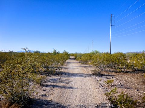
Maricopa Trail heads south, paralleling dirt Cortez Rd. and a powerline to the right and, further away on the left, a levee which protects Surprise’s sardine developments from Trilby Wash flooding. The trail is wide, straight and flat. The primary vegetation is creosote, whose flowers were fading.
After one mile, the Maricopa Trail turns east, now paralleling dirt Greenway Rd. In ¼ mile, the trail passes through a gate, crosses the road, passes through another gate, heads south for a ½ mile, then turns back to the west for a couple hundred yards, before turning south again. 🛩
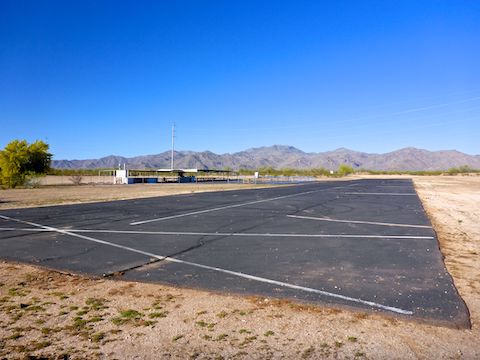
All that turning diverts the Maricopa Trail around an RC plane airport. I was disappointed no one was flying. The airport’s shade, shelter, picnic tables and outhouse would make a good stealth camping spot. (I saw a “Smile: Your image was just captured and xmitted to the Maricopa County Sheriff” sign, but no camera or related commo gear.)
Back on Maricopa Trail, it heads south for ⅓ mile, before bending southwest for nearly three miles. Basically, it is straight, but there are little curves all along it. The trail gets narrower as it heads south, gradually becoming single track.
To the west, the antenna farm atop 4083 ft. el. Barry Goldwater Peak is obvious. I’ve never been up there, though I have hiked Ford Canyon several times. The White Tank Mountains just don’t have a lot of trails. It would be nice if they put a couple of trailheads on the west side of the range. Today, at least, the mountains were also hard to photograph. It was quite windy, so maybe there was too much dust in the air. 🤔
Saguaros start appearing about 1½ miles south of the RC plane airport. (That sounds kind of awkward, but I can’t find a name for it like “Sky Harbor”.) About halfway into the hike, there is a cowbell hanging over the Maricopa Trail. The breeze was heavy enough to rattle it.

The Maricopa Trail gets a few whoops (small bumps) and wash crossings to keep things from being too boring for mountain bikers. So far, nothing my old fat ass couldn’t handle. Just short of five miles south of Sun Valley Trailhead, at a jeep trail intersection, the Maricopa Trail bends sharply right along the bank of a wash.
The Maricopa Trail begins climbing ever so slightly. (The total accumulated elevation gain for the first five miles? 55 ft.) At 5½ miles, the trail reaches a combo gate, which marks the boundary of White Tank Mountain Regional Park. Just past the gate, turn left onto Mule Deer Trail. 🦌
Mule Deer Trail crosses to the wash’s opposite bank and begins switchbacking up a small hill, gaining 100 ft. in ⅔ mile. Though I was hiking, the climb is just within my MTB wheelhouse. Despite not being very prominent, the top of the climb has a surprisingly good panoramic view of the Valley of the Sun.
On the climb up the small hill, then along the last 1½ miles of Mule Deer Trail, I finally started seeing some real desert flowers: One small cluster of small Mexican gold poppy, one each blooming strawberry hedgehog, cactus apple prickly pear, and teddy-bear cholla (with the first green flower I remember seeing).
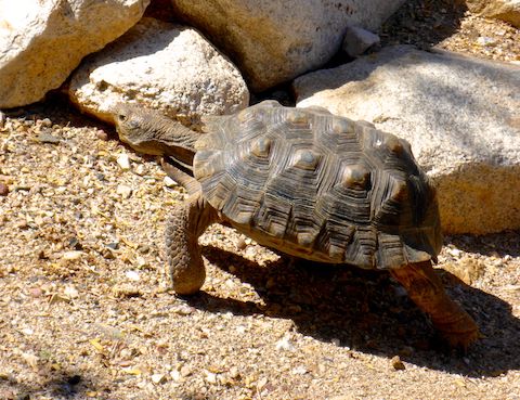
The day had so far been pleasant, but it was starting to heat up on that final stretch of Mule Deer Trail. There were a few more mountain bikers on it, and quite a few older hikers. The only other terrestrial creatures I spotted, besides lizards were a lone cow, and a captive desert tortoise at the White Tank Library / visitors’ center.
After finishing my hike, my shuttle driving wife & I meandered back to the Loop 303. Despite all the new developments in Surprise, there were ZERO gas stations or fast food drive-thrus on four miles of Olive Ave. or at the 303 / Peoria Ave. intersection. I had to wait until I was nearly home to get lunch and an ice cold soft drink! 😢
Sun Valley TH Directions: Take Loop 303 exit 116, west onto Bell Rd., which by this point is well clear of Sun City. In 2½ miles, the road rises to cross a wash, becoming Sun Valley Pkwy. The trailhead is a ½ mile further, on the left.
White Tank Library Visitors’ Center: Take Loop 303 exit 112. Take the first left, onto Cotton Ln. In one mile, turn right on Olive Ave. In 4.0 miles, just before the pay gate, turn right into the visitor’s center parking lot — which is free.
GPS File: Maricopa_Trail_Sun_Valley_Pkwy_to_White_Tanks
Distance: 8.64 mi.
AEG: 277 ft.
Time: 2h 48m
Hike Video
Maricopa Trail: Sun Valley Pkwy. to White Tank Mountains from Preston McMurry on Vimeo.