

For our annual Easter visit to Hagerstown, I had two C&O Canal hikes scheduled: First, from Four Locks to Ft. Frederick (MP 108.7-112.2), then from McMahon’s Mill to Williamsport (MP 88.1-99.4). With some time on the hotel ellipitical machine in beween. Egg hunting too. 🐣
A canal along the Potomac River was first conceived by George Washington, who’d spent much of his youth surveying the area northwest of Mount Vernon, as far as what is now Pittsburgh. After the Revolution, Washington’s Potowmac Company built skirting canals around the major falls below Harper’s Ferry.
The Erie Canal, in upstate New York, was completed in 1825, forcing traders further south to upgrade their transportation system along the Potomac River. Originally, the C&O Canal was planned to extend from the District of Columbia to Pittsburgh, but prohibitive costs ended construction in 1850, after 184.5 miles, in Cumberland, MD. (Primarily, because the railroad got to Cumberland first, in 1842.)
I started hiking today’s segment of the C&O Canal from Four Locks at 7:30 a.m. Flowers in Maryland seem to do very well in temperatures that Arizona flowers wouldn’t get within 30 degrees of. It was a beautiful morning: Perfect temperature, barely a cloud in the sky. 🤗
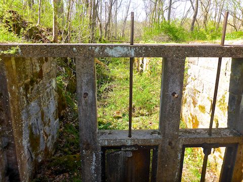
At Four Locks, I’d seen a guy unlock a gate, so a pickup could drive up on the C&O Canal towpath. I caught up to them a ½ mile later. There we doing something on the landward side of the canal, near a decrepit wood building. The ruins were unsigned. As was the inlet lock (pictured above), 150 yds. later.
The inlet lock marks the west side of Prather’s Neck — which Four Locks bisects, saving the C&O Canal 3½ miles of construction. Past the inlet lock, on the Potomac River flat, was a dense patch of Virginia bluebell that was at least ⅓ mile long.

Top Row: common blue violet, Eastern spring beauty, Virginia bluebell.
Middle Row: downy yellow violet, purple dead nettle, cutleaf toothwort.
Bottom Row: rue anemone, dandelion, wild blue phlox.
MP 109.6: North Mountain Campground has the usual portapotty, picnic table, grill, fire pit, direction & distance sign and doggie doo bag dispenser. Unlike many of my other C&O Canal hikes, the well hand pump had a handle. I pumped it a few times, but no water issued forth. Probably because I had not built up enough pressure. Camping is free.
MP 110.2: McCoy’s Ferry Campground has 12 single sites and one group site, each with room for a trailer up to 20 ft., picnic table, grill and fire pit. There are multiple portapotties, and a pit toilet by the boat landing. Cost is $20 / night for a single site; $40 / night for the group site. 🏕
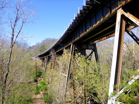
At the east end of McCoy’s Ferry Campground, on the C&O Canal, there is what appears to be a lock. Like the inlet lock earlier, it is unnumbered and unsigned. The campground is accessed by McCoy’s Ferry Rd. 100 yds. north of the C&O Canal, the road is crossed by a high railroad trestle. The trestle is the most interesting structure between Four Locks and Ft. Frederick.
The next two miles of the C&O Canal towpath are casual strolling, devoid of historical interest. The most interesting feature was the abundant vines. I don’t know from vines, but I’m certain they were not kudzu. Given their density, though, my best guess is they are winter creeper, a highly invasive non-poisonous vine related to poison ivy. 🍃
MP 102.2: Ft. Frederick Rd. crosses the C&O Canal. I knew the fort itself was uphill to my right, but I first went left. Just curious. After briefly checking out Beaver Pond — which appears not to be part of Big Pool — I headed back uphill.
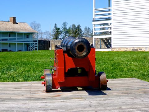
Ft. Frederick Rd. passes between two open fields, which would make great fields of fire if the fort still mounted 6-pounder cannon on its bastions. Now, the fields are a black powder musket range, used by Colonial-era reenactors.
As I approached Ft. Frederick, there were wood buildings to my left and straight ahead. Left is Capain Wort’s Sutlery (the park store), restrooms, parking, and a path to the visitors’ center. Straight ahead is the C.C.C. Museum, for the Depression-era workers who built the buildings. The sutlery and museum were both closed.
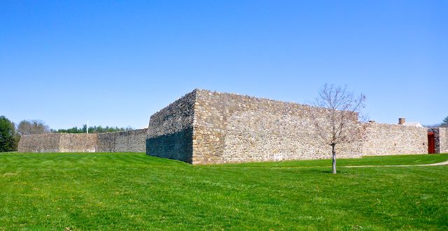
Ft. Frederick’s gate is on its south side. (No pets or bikes are allowed inside.) The gate is topped by anti-personnel spikes. The fort’s stone walls are 4 ft. thick at the bottom, 2 ft. and angled higher up. Not exceptionally thick by European standards, but enough to withstand the firepower available on the Colonial frontier, in an era when other forts were wooden. 🪵
Inside Ft. Frederick, there is a well, 6-pounder cannon, and two wooden 2-story barracks, each capable of holding 100 troops (200 in a pinch), plus “camp followers”. All that’s left of the officers’ quarters is foundation. I could see relics inside the Colonial wavy-glass windows, but those doors were locked as well. I guess things open up after Memorial Day.
After my wife picked me up, we drove out west of Clear Spring on US-40, for lunch at Clear Spring Country Diner. We both had bacon cheeseburgers, and I got a slice of coconut cream pie for desert, even though the hike was not long enough to justify the additional delicious calories. 👍👍
Four Locks Directions: From I-70, take exit 18 north onto MD-68 / Clear Spring Rd. At the light, turn left on US-40. At the next light, turn left on Martin St., which becomes Big Spring Rd. Mind the one-lane bridge in the hamlet of Big Spring. In 2.4 miles, turn left on Four Locks Rd. In 0.6 miles, take a slight right onto Starliper Rd., which curls left under Four Locks Rd. to the boat ramp. Mind the two narrow tunnels along Four Locks Rd. and Starliper Rd.
Ft. Frederick Directions: From I-70, take exit 12 south onto MD-56 / Big Pool Rd. In 1.2 miles, turn right into Ft. Frederick State Park. In 200 yds., the road splits: Right to the visitor’s center, left to the actual fort. In 0.5 miles, park next to the sutler’s cabin, across from Ft. Frederick.
GPS File: CO_Canal_MP109to112_Four_Locks_to_Ft_Frederick
Distance: 5.80 mi.
AEG: 158 ft.
Time: 2h 02m
Hiking Video
C&O Canal: Four Locks to Ft. Frederick from Preston McMurry on Vimeo.