

Counter-clockwise from Bronco Trailhead, this is the 18th segment of the Maricopa Trail.
Last month, I was in Maryland, day hiking the 184 mile Chesapeake and Ohio Canal towpath. I have only three segments to complete that project. I am even closer — just one segment! — to finishing the 93 mile Black Canyon Trail. Last Fall, I began a fourth project, the 160 mile General Crook Trail. 😅
Four? But you only listed three projects!
The other project would be the subject of this blog, the Maricopa Trail, a 245 mile loop around metro Phoenix. One guy actually did the whole thing in one shot, running all 245 miles in just under 70 hours. My fat, aging, ass is taking a bit longer.

Park of the Canals to Granite Reef Dam is nine miles. At the dam, the Maricopa Trail turns northwest across the Salt River. (Due to heavy monsoon floods, the crossing at Granite Reef Dam was inaccessible a month ago.) If you stay south of the Salt River, it is only another mile to the Granite Reef Recreational Area, which has picnic cabanas, pit toilets, etc. but costs $8 to park.
So, the Maricopa Trail from Park of the Canals to Granite Reef Dam is hikeable one way and bikeable out & back. Especially considering the route follows the nearly flat South Canal for nine miles. As there are no parks between Park of the Canals and Granite Reef Dam, any intermediate “trailhead” would have to be whatever bit of empty desert is available. 🅿️
Previously, the east / south side of the canal was preferable due to being paved. From Park of the Canals to Granite Reef Dam, the west / north side of the canal is preferable, due to the opposite side often dead ending at private property or various canal structures. (Except for crossing Horne Rd. and McKellips Rd., in the first mile, where the bike path signal is on the opposite side.)
From Park of the Canals, head south on Horne Rd. for 100 yds., then turn left, crossing the road. In ½ mile, cross McKellips Rd. The bike path signals are on the opposite side of South Canal. Horne Rd. and McKellips Rd. are the only two high traffic road crossings on this Maricopa Trail segment.
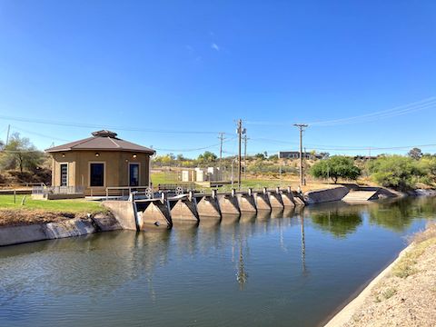
1½ miles into this Maricopa trail segment, there is a Salt River Project (SRP) electrical substation, portapotty (with hand wash) and what, for want of a better word is a one foot tall “dam”. I dunno. Water was audibly spilling over it, despite its lack of size. The first two miles of this Maricopa Trail segment, to the Gilbert Rd. underpass, were unpleasantly rocky, like biking Biscuit Flat. 😖
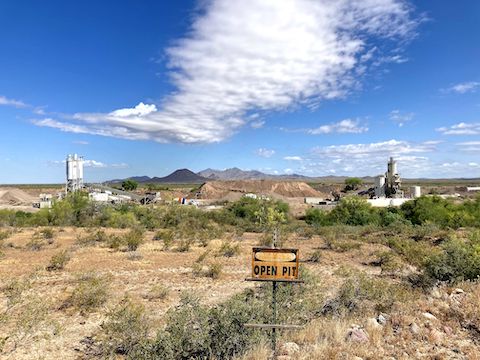
Just west of the McDowell Rd. underpass, at 2½ miles, the South Canal has a 30 ft. falls. Just above the falls, out of sight from the Maricopa Trail, is the Eastern Canal diversion dam. At 3¾ miles, Mesa’s Val Vista Water Treatment Plant is on the right. On the left is the Vulcan Materials quarry, across which is a nice view of stand alone Sawik Mountain and, beyond that, the McDowell Mountains.
I never did see any horse riders — or signs thereof — despite northeast Mesa having some large lots, and the Maricopa Trail passing right next to an equine boarding ranch at the Red Mountain Freeway. There were a couple of dog walkers, joggers and bike riders, but not nearly the same level of pedestrian traffic as the previous Maricopa Trail segment from Freestone Park to Park of the Canals.
The third & final underpass is for Red Mountain Freeway / Loop 202, at 4¾ miles. Northeast of the freeway, there is Salt River flood plain to the left, and “defense system” facilities to the right. By the time I passed the Higley Asphalt quarry at 6⅓ miles I was wishing I’d brought my Camelbak. (I had two nalgene bottles, of which I usually drink little more than one on my 17-mile Mega Church Loop.) 🚴🏻♂️
At 7⅓ miles, I passed what looked like it might be a rough trailer park, or another quarry. However, it has no access road other than the canal service “road” which forms this Maricopa Trail segment. Neither is there a bridge to the black helicopters on the other side of the South Canal.
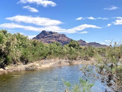
At just under eight miles, next to the South Canal, is some sort of solar-powered contraption. Maybe a stream gauge? To the left are some small mounds. I hid my bike behind the mounds, following a foot trail 100 yds. to the Salt River side channel pictured above. Being short on water, I didn’t bother with the main channel.
The Maricopa Trail turns left across the Salt River at nine miles, on the downstream side of Granite Reef Dam. The crossing is still closed. After taking pictures of the dam, and Red Mountain, I instead turned right, crossing South Canal, then riding along the lower slope of Schlechts Butte.
I knew where I was. I knew where Granite Reef Recreation Area was. But lacking my GPS, I did not know how to make my way through the dense brush from one to the other. It took me 20 minutes before I found a way through. My recommendation is to instead park at the Bush Highway Trailhead: It’s the same distance, and right up the dirt access road you are riding on anyway.
I’ve now completed 170.96 miles of the Maricopa Trail.
Park of the Canals: From Phoenix, take the Red Mountain Freeway (Loop 202) east. Take exit 12 east onto McKellips Rd. In just under two miles, turn right on Horne Rd. In ½ mile, just before crossing the canal, turn right into Park of the Canals.
Bush Highway Trailhead: From Phoenix, take the Red Mountain Freeway (Loop 202) east. Take exit 23A east to Power Rd. Turn left. In 2⅓ miles, as the road curves right, turn left into the Bush Highway Trailhead. There is no fee. Or continue ¼ mile, then turn left into the Granite Reef Recreation Area, which has toilets, picnic tables, etc. and requires an $8 Tonto Day Pass.
GPS File: Maricopa_Trail_Park_of_the_Canals_to_Granite_Reef_Dam
Distance: ~12.00 mi.
AEG: ~225 ft.
Time: ~1h 50m
Biking Video
Maricopa Trail: Park of the Canals to Granite Reef Dam from Preston McMurry on Vimeo.