

Counter-clockwise from Bronco Trailhead, this is the 17th segment of the Maricopa Trail.
One of my current projects is to hike or bike all 245 miles of the Maricopa Trail — or at least those portions which did not wash away in this year’s massive flash floods. (The crossing at Granite Reef Dam was inaccessible last week.) After today’s hike through Gilbert and Mesa, from Freestone Park to Park of the Canals, I’ve hiked or biked 67% of the loop around the Phoenix metro area.
A Freestone Park – Park of the Canals out & back is 15 flat canal miles, so an easy bike ride, and even doable as a walk. Instead, I chose to hike it one way, south-to-north, which is counter-clockwise on the Maricopa Trail. (Thanx to my ever helpful shuttle driver, who also goes by the name of “wife”.) 😁
Since the various Maricopa Trail segments tend to be similar, such as along canals and sidewalks, I try to mix up the format of my videos. Some segment highlights; some thing the whole segment. Some sped up; some real time. Some with music; some natural sound.
Some my GoPro is chest-mounted; some it is on my bike’s handlebar. On the handlebar, some I keep the camera straight ahead, and others — like two weeks ago between Pima Canyon and Freestone Park — I rotate the GoPro through various angles. This week, instead, my video is a slideshow. 📸
Technically, the Maricopa Trail does not intersect Freestone Park, but follows the west side of the Consolidated Canal ⅓ mile north to an unsignalled and unprotected crossing of busy Lindsay Rd. Instead, it is safer to cross at the signal on Freestone Park’s southwest corner, then head up the sidewalk on the east side of Lindsay Rd.
Once Consolidated Canal crosses Lindsay Rd., the Maricopa Trail is a concrete path, on the east side of the canal, the next 7¼ miles to Tempe Canal. After Lindsay Rd., it is only another ¼ mile to the next major road crossing — Guadalupe Rd. — which is also busy, unsignalled and unprotected.
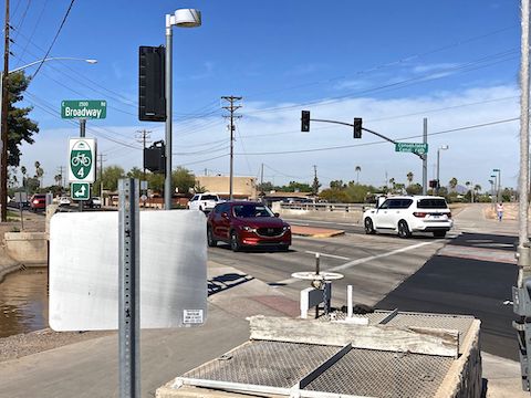
Past Guadalupe Rd., every major street crossing — Baseline Rd., Southern Ave., Lindsay Rd. (again), Broadway Rd., Main St., University Dr., Stapley Dr. and Brown Rd. — is signalled and protected. I used the signal to cross Baseline Rd., but after that waited for breaks in traffic, then jogged across, rather than make the vehicles wait another 20 seconds afterwards. 😇
The 2-lane streets — 8th St. and Horne Rd. — having less traffic, are unsignalled, but protected. What do I mean by “protected”? That there is a curbed island in the middle of the road, which provides a buffer between you and passing vehicles. Theoretically. There’s a lot of disracted drivers these days. Stay alert! Stay alive!
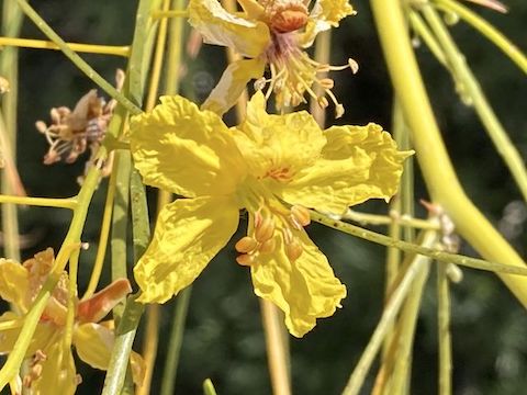
Like I said earlier, the concrete path is on the east side of Consolidated Canal; on the west side is an older asphalt path. A wide dirt path is also often on the west side of the canal and, occasionally on the east side as well. In the early Gilbert miles, the west side had small horse properties. Yet, every time I switched sides, so would the corrals. Doh!
I never did share this segment with horses. Bicycles were another story: There were tons of them, often in groups of a dozen or more riders. Some even being pedalled. I have no love for “eBikes”, but an even worse phenomenon is small, gas-powered, bikes that zip along at 30 mph. After one blasted past me, he turned left on Brown Rd. It was so loud, I could hear him for a minute after he disappeared! 🖕😠🖕
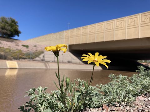
The 17th Maricopa Trail segment passes several pocket parks — Neighborhood Park, Harmony Park, Meadowgreen Park, City of Mesa Basin and Blue Moon Park — which also serve as storm drainage sumps. Meadowgreen Park (3 mi.) and Blue Moon Park (7 mi.) had trailside cabanas and water fountains. There are no rest rooms, unless you count the Whataburger on Broadway Rd. (3⅔ mi.)
On reaching Horne Rd. (the first time), the Maricopa Trail continues west. As Park of the Canals is on Horne St., you could turn right up the sidewalk for ⅓ mile to the park, or stay on trail for the remaining ¾ official miles.
On the far side of Blue Moon Park, Consolidated Canal terminates at a large division gate. Tempe Canal continues west, while the cement Maricopa Trail path turns north along the east side of the South Canal. Because I was not continuing ten miles to Granite Reef Dam, I crossed to the west side of South Canal for the final short stretch to Park of the Canals. (SRP History of Arizona Canals)
I’ve now completed 161.94 miles of the Maricopa Trail.
Freestone District Park Directions: From Phoenix, take US-60 east. Take exit 182 south onto Gilbert Rd. In ½ mile, turn left on Baseline Rd. In 1 mile, turn right on Lindsay Rd. In just over a mile, after crossing over the canal, turn left on Juniper Ave. Park in the first parking lot on the right.
Park of the Canals: From Phoenix, take the Red Mountain Freeway (Loop 202) east. Take exit 12 east onto McKellips Rd. In just under two miles, turn right on Horne Rd. In ½ mile, just before crossing the canal, turn right into Park of the Canals.
GPS File: Maricopa_Trail_Freestone_Park_to_Park_of_the_Canals
Distance: 8.36 mi.
AEG: 34 ft.
Time: 2h 36m
Biking Video
Maricopa Trail: Freestone Park to Park of the Canals from Preston McMurry on Vimeo.