

Counter-clockwise from Bronco Trailhead, this is the 11th segment of the Maricopa Trail.
One of my current projects is to hike or bike all 245 miles of the Maricopa Trail, which loops around the massive Phoenix metro area. (How massive? 70 miles across and 50 miles north-to-south.) After today’s hike from Estrella Mountain Regional Park to Phoenix International Raceway (PIR), I’ve completed ~112 miles. Not even halfway. Since hiking in 115℉ summer temps isn’t a practical option, I will be increasing my pace to two segments a month in order to hopefully finish before the end of the 2023. 🙏🏻
My other current hiking projects are the C&O Canal Towpath (Maryland), plus the Black Canyon Trail and General Crook Trail (both in Arizona). I hope to also complete the C&O Canal Towpath and Black Canyon Trail in 2023, and the General Crook Trail in 2024.
The segment of the Maricopa Trail from Estrella Mountain Regional Park to Phoenix International Raceway, starts behind the Visitors’ Center. Walk along the packed gravel path, past the mosaics. The final mosaic is a compass set in the ground. Right is to the desert tortoise enclosure. Go left to the Quail Trail, which starts past the portapotty & picnic table, across the access road.
Quail Trail is 1.1 mile, 192 ft. accumulated elevation gain (AEG) trail that heads south to the Rainbow Valley Trail. That’s not much AEG for a mile, but the initial climb past the Tres Rios Golf Course is a steep enough to get your heart pumping. ❤️
The highlight of Quail Trail is just off trail to the right: Behind a corrugated metal tank, are the ruins of what I believe is a camp site, not a ranch. I say camp site because there is a grill, barbecue and short retaining wall (with no foundation). There are two small cement bolt supports, but no indication what they once held. Amongst it all is some rock art, though nothing as extensive as Sundad.
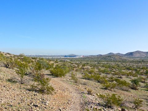
Rainbow Valley Trail follows the contour line, before descending towards the rodeo arena, after ¾ mile. Or what used to be the rodeo arena. There are no more fences, bleachers or horses for rent. Nothing except the restroom building. (Which is the cleanest trailhead facility I’ve ever been in.) There’s nice views southeast from above the rodeo arena.
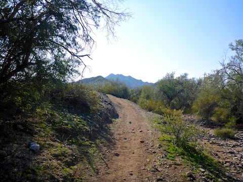
Toothaker Trail parallels the west edge of the rodeo arena parking lot. Toothaker Trail is almost four miles, but the Maricopa Trail turns off it after only 200 yds. From here to Phoenix International Raceway, each trail is basically the same MTB-optimized, mostly smooth-surfaced, rolling track, with multiple minor to moderate wash crossings. 🚴🏻♂️
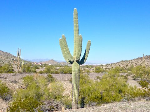
Butterfield Trail heads south for a mile. As on my previous visits to Estrella Mountain Regional Park, the main attraction was looking for interesting saguaro.
Gadsden Trail is longer than the 2¼ miles it is followed by the Maricopa Trail. Gadsden Trail has seen numerous small mountain bike-optimized reroutes since I first hiked it over a decade ago. Where new track intersects old, there is always some sort of sign indicating which way to go. Just before the small hill with the stone X, turn left onto Desert Rose Trail.
When I started hiking the temps were in the 30s, but I was generating enough body heat I was never uncomfortable. (Which sure beats the -19℉ at Mormon Lake.) 🥶
Small planes were flying overhead all morning — they apparently use the stone X as a navigation aid — but what really get my attention was the loud roar of F-35s at Luke Air Force Base, 12 miles away. I’ve heard the F-35s as far away as North Mountain!
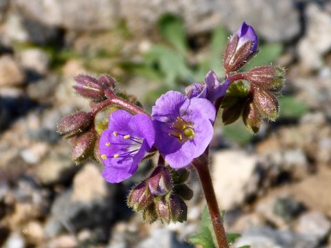
Desert Rose Trail is a little over three miles, ending in a gravel lot just outside fenced & locked Phoenix International Raceway. Besides PIR’s blue walls, the only other color was the scorpionweed I chanced across while diverting off trail to photograph a saguaro. 🌵
Not sure why Maricopa County trail planners didn’t take advantage of the straight shot to PIR. Instead, Desert Rose Trail is switchbacked up a 240 ft. hill. The saddle at the top of the climb had nice views back the way I came. Despite its proximity to the competitive mountain bike track, hikers, horses and other pedestrians are welcome on Desert Rose Trail.
I’ve been trying to do more hikes wearing a Camelbak, rather than carrying hiking poles and carrying a full pack, and it paid off today: I was able to hike from Estrella Mountain Regional Park to Phoenix International Raceway in a quite speedy 3.26 mph.
Estrella Mountain Regional Park Directions: From I-10, take exit 126, south onto Estrella Parkway. In 5 miles, just over the Gila River, turn left onto Vineyard Ave. In a half mile, turn right into the park, onto Casey Abbot Dr. The entrance fee is $7. (It helps keep our parks nice.) Take the second quick right after the gate into the Nature Center parking lot. (To continue to PIR, continue east on Vineyard Ave. as it bends right to become 143rd Ave., then left to become Indian Springs Rd.)
PIR Directions: From I-10, take exit 131, south onto Avondale Blvd. In 5 miles, curve right over the Gila River. Phoenix International Raceway will be on your left. In 1½ miles, make the first left after Gate G, at the brown Estrella Mountain Regional Park sign, onto Avenida Estrella. In ⅓ mile, turn left into the park. Park in the first dirt lot on the right.
Park Map: Estrella_Mountain_Regional_Park_Trail_Map
GPS File: Maricopa_Trail_Estrella_to_PIR
Distance: 9.19 mi.
AEG: 882 ft.
Time: 2h 49m
Hiking Video
Maricopa Trail: Estrellas to Phoenix International Raceway from Preston McMurry on Vimeo.