

16,283 acre South Mountain Park is the largest city park in the United States. It is popular with the usual array of Phoenix outdoor activities: Hikers, dog walkers, mountain bikers, and road bikers (the pedal kind). The multiple lookouts dotted along Summit Rd. are popular picnicking & sunset viewing spots. There’s even a quarter midget track! 🏎
South Mountain Park has quite a few trailheads, large & small, dotted around it’s perimeter, but surprisingly few official trails considering it covers 25 square miles. (See the trail map attached below.)
There are trails at South Mountain Park to fit every hiker’s ability, from the ½ mile, wheelchair-accessible, Judith Tunell Trail to 15 mile, 2,500 AEG (accumulated elevation gain), National Trail. Desert Classic Trail is rated one of the top mountain bike trails in the country.
Desert Foothills Trailhead has about 80 parking spaces, but none for horse trailers. The trailhead has three 1-person coed flush toilets with sinks, water fountains, a shady rest area with concrete “benches”, and the usual array of information signs. Most of the spaces were available at 7:30 a.m. on a Thursday.
Today was another locals’ hike, my plan being to hike from Desert Foothills Trailhead north along Telegraph Pass Trail to the pass at Summit Rd., then east around the Mount Suppoa summit along National Trail to Buena Vista Trailhead, south past Chinese Wall along Corona de Loma Trail, and finally back to the trailhead along Desert Classic Trail. It may sound like a death march, but it’s not: Just a solid workout at 9.4 miles and 1,600 AEG. (My mileage is longer due to wandering about taking photos.) 📸
I had planned on waiting until 8:30 a.m. to start my hike, but I got to Desert Foothills Trailhead early, so after shooting my video intro I headed out. My timing could not have been better! I turned to look east just as the sun burst over the edge of some hills.
The first 0.4 miles of Telegraph Pass Trail, along the edge of the Camelot Ridge neighborhood, is wide, rough concrete. Not sure why they did that, instead of smooth concrete or plain ol’ dirt. At the end of the concrete, the loop begins. (And eventually ends.)
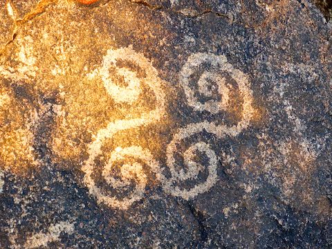
I turned left, clockwise, as Telegraph Pass Trail turned to normal dirt & rock single track. The Hohokam petroglyphs are in a ¼ mile, mostly behind a fence. From the petroglyphs, the trail pitches up, climbing 350 ft. in the next 0.4 miles to Summit Rd. at Telegraph Pass. The climb is steep, but short. The hardest part is the number of stoney step ups. There is a bench, several good sitting rocks, and a pullout with room for several cars. If you look to your left, you will see the National Trail Lookout, which is an extra ½ mile and 200 AEG if you want to head up there. 🔭
At Telegraph Pass, I instead took a sharp right, east onto National Trail, which parallels Summit Rd. for a mile. Being on the north slope of Mount Suppoa, the trail was deep in shadow even at 9:00 a.m. It climbs 450 ft. in 1.5 miles to a saddle just east of the antenna farm. Surprisingly, there is a summit log there. I had to sign it, pimping this blog’s URL in the process.
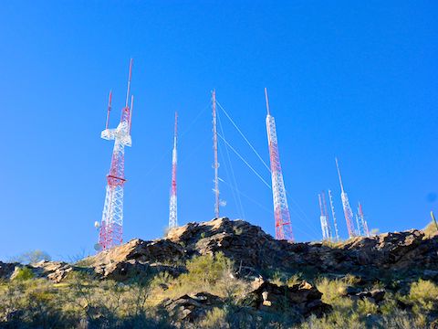
A ½ mile after the summit log, National Trail crosses TV Road, which splits off Summit Rd. to access the antenna farm and Gila Valley Lookout. In another 0.6 miles, National Trail intersects Corona de Loma Trail 100 yds. from Buena Vista Lookout. My crappy Garmin 62S threw a fit, so I had to backtrack a bit before heading down.
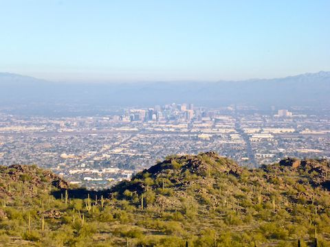
Chinese Wall is a small, 300 yd. long cliff, southwest of Buena Vista Lookout. There is a view of it from National Trail, but the best view is from Corona de Loma Trail, 200 yds. below Buena Vista Rd. Corona de Loma descends 150 ft. in a ¼ mile, follows a wash bottom for another ¼ mile, then switchbacks up 150 ft. in yet another ¼ mile to a saddle where I took my only break. There are great views south from that saddle … Or there would be if there was not a dense, thick layer of smog all along the I-10 southbound corridor. It was 1970s Los Angeles-level pollution. (I know: I lived in L.A. back then.) 🤢
From the saddle, Corona de Loma Trail descends 700 twisty, rocky, feet in ¾ of a mile to the Lower Corona Trail. I’m glad I went down, instead of up it.
Lower Corona Trail is an extension, or alternate routing, of Corona de Loma Trail. Lower Corona is also where I encountered my first two mountain bikes of the day. It descends 150 ft. in a ½ mile to Desert Classic Trail.
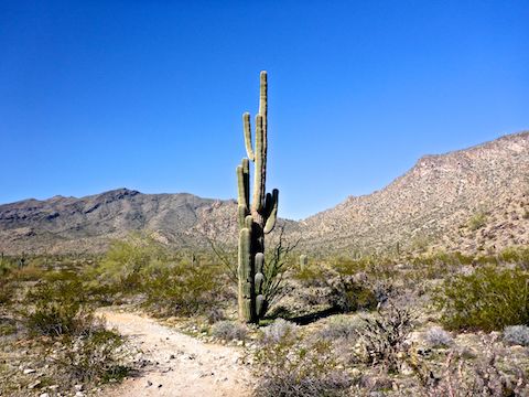
Desert Classic Trail might be one of the top rated mountain bike trails in the country — and a lot of them passed me — but for hiking it was underwhelming. Basically flat, crossing a few random washes, Desert Classic accumulates a massive 300 AEG in 3.1 miles. The best part of Desert Classic is some interesting saguaro. It sure isn’t the ¾ of a mile right along some mansions’ back fences. 😒
After completing the loop at Telegraph Pass Trail, it was a quick jaunt along the rough concrete path back to the Desert Foothills Trailhead. I took a few minutes of a hiking beer free break, then headed south on Desert Foothills Parkway to the Loop 202 South Mountain Freeway. I killed two birds with one stone today: First, getting some good exercise; second, concluding my survey hike project by actually driving the new freeway over Main Ridge North and Main Ridge South, past Vee Quiva Casino and Dusty Lane, then through Laveen to westbound I-10.
Directions: There pretty much used be just one way to get here, but now that the Loop 202 South Mountain Freeway opened in December, take Loop 202 to the currently unnumbered Desert Foothills Pkwy. exit. North is the only way you can go, so head that way for 2.4 miles. Beware the 15 mph school zone, with unattended speed radar van! At the top of the hill, on the right is the trailhead. (I almost drove by it, so keep an eye out.) There is no entry fee.
Park Map: South_Mountain_Park_Trail_Map (pdf)
GPS File: Telegraph_National_Corona de Loma_Desert Classic
Distance: 10.19 mi.
AEG: 1,652 ft.
Time: 3h 47m
Hike Video
Hiking South_Mountain Park, Phoenix from Preston McMurry on Vimeo.