

Heading east from Dewey, this is the 11th segment of General Crook Trail.
I was going to meet up with a friend at Larson Ridge for a cookout, so I planned a hike I thought I could finish by early-afternoon. He had to bail, but I went ahead with hiking the General Crook Trail anyway.
Planning for the hike, I used three topo maps — none of which completely agreed on the route taken by the General Crook Trail. In some parts they agree, and in others may be off by as much as a half mile. In 1976, Boy Scouts marked another route with cairns, reflective chevrons and mileage posts. (P markers for miles from Camp Verde west to Prescott; V for miles from Camp Verde east to Fort Apache.) 🤔
As I’ve divided the General Crook Trail into day hike sized chunks of 8-12 miles, today’s is the 11th segment, from Forest Lakes to FR 487. Ten years ago, Tortoise Hiker and The Eagle hiked this segment (and more), adding an additional route. I tried my best to find the middle road. So to speak.
When my wife and I arrived in Forest Lakes, I drove her on a scouting trip down Rim Road to FR 487 (aka Old Verde Road). I wanted to show her where the campgrounds / pit toilets were, and where to pick me up. Note that on the topo maps, Old Verde Road is labelled “FR 87”, but current signage indicates it is now FR 487. (Terrain may change slowly, but topos can often be decades out of date.)
Driving on Rim Road was very slow, as my SUV’s shocks are shot. (It’s going into the shop on Monday.) Rim Road is rocky in spots, but is otherwise in better condition than it’s more popular stretch between Milk Ranch Point and Willow Springs Lake. In good weather, Rim Road should be car drivable, at least as far as FR 487. The highlight of the drive was a small herd of wild horses. 🐴
I finally got started hiking the General Crook Trail at 10:00 a.m. It was cool, with winds up to 15 mph. There were still a few small patches of snow. I wore my hoodie. Other than taking the hood off, or adjusting the zipper, I did not remove it all day. Even though the temps gradually increased to about 60℉, and the wind died down, I never got sweaty. The sky was sunny, a brilliant blue, all day.
The General Crook Trail’s 11th segment starts east on FR 9316. In 50 yds., the V80 marker is obvious on the right. After ½ mile, on the right is rusty corrugated metal tube and an unmarked carbonite post. That is where the General Crook Trail supposedly splits off FR 9316. There was no use depression, but I gave it a shot. Pine forests are normally open, but the brush was dense. 🌲
After 250 yds., I got back on FR 9316. My recommendation is to simply stay on FR 9316 for 1⅔ miles to Rim Road at grassy Nelson Lake. (A “lake” in name only, as it was shallower than Brad Tank, Double A Tank and Scott Tank.) At Nelson Lake, the General Crook Trail topo route turns south, following an old jeep trail to FR 19. Searching for reflective chevrons, I split the difference between it and Rim Road.
The third chevron I spotted, between Double A Tank and Scott Tank, was where the V82 marker was supposedly located. I searched for 10 minutes and could not find anything with “V82” on it, or which looked like it might have once had “V82” on it. Only two miles into the official General Crook Trail route after 80 minutes, I hiked the rest of the way on Rim Road.
The GPS route attached below indicates one topo map’s version of the General Crook Trail. Note that after 2⅔ miles General Crook Trail goes right up the middle of Rim Road. Because crossing canyons slowed travel, could break wagon axles, and made excellent Apache ambush sites, the General Crook Trail / Rim Road follows a ridge’s high line from Forest Lakes, 15 miles southeast to FR 51.
At FR 51, Rim Road continues along the highline for 40-something miles to Pinetop-Lakeside, while the topo maps claim the General Crook Trail turns northeast towards Clay Springs. Fort Apache is on the White Mountain Apache reservation, 25 miles south of Pinetop-Lakeside, along what is now AZ-73, so I suspect the historical trail more likely followed that route. (See “Vanished Arizona” for period detail.) 🏜
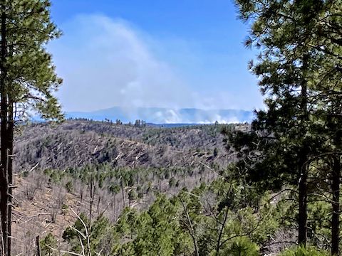
The General Crook Trail ridgeline is relatively flat as such things go, but there are still views down Hangman’s Draw, Gentry Canyon, Big Canyon, Bull Flat Canyon and northeast in the general direction of Overgaard. The top of the ridgeline is mostly heavily wooded, and there are downslope clusters of trees, but the 2002 Rodeo-Chediski Fire so thoroughly burned them recovery has not yet begun.
Black Canyon Rim Campground and Gentry Lookout / Campground survived the fire. My wife surprised me at the apparently unstaffed Gentry Lookout. I scarfed the other half of her ham sandwich, she told me the pit toilet was locked, and I headed back out.
I found both the V85 and V89 markers. Neither had any paint. I could barely see the etching on V85, nothing on V89. If you didn’t know there were there, and what they were for, you’d think they were old fence post. Lacking “General Crook Trail” signs like the segments west of Camp Verde, you wouldn’t know Rim Road was a historical trail at all.
Rim Road has its own set of much more obvious mile markers. On this General Crook Trail segment, the mile markers count up from 44 to 52. Despite the bad shocks, my wife was able to meet me at FR 487, just ¼ mile past mile mark 52. While drinking my recovery V-8, I found the reason my toes were sore: Not from blisters, but being cut up by untrimmed toenails. It ain’t hikin’ if you ain’t bleedin’! 😆
Forest Lakes TH Directions: From Phoenix, head north on AZ-87, the Beeline Highway, into Payson. Turn right on AZ-260. In 37 miles, with the Rim Resort Gas station just ahead on the left, turn right onto the dirt road. Park there, right next to AZ-260.
FR 487 TH Directions: Continue east, past the Rim Resort Gas station. In little over a mile, just past AZ-260 mile marker 291, turn right onto dirt Rim Road / FR 300. Notice the Rim Road mile markers every mile. In little over 8 miles, just past Rim Road mile marker 52, FR 487 is on the left. Park wherever.
GPS File: General_Crook_Trail_V80_V89
Distance: 11.43 mi.
AEG: 548 ft.
Time: 3h 54m
Hike Video
Hiking General Crook Trail: V80-V89 from Preston McMurry on Vimeo.