

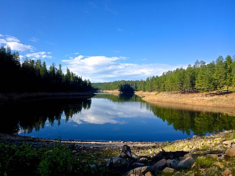
East Leonard Canyon is a 6-mile long canyon, located on the Mogollon Rim. Knoll Ridge forms its west flank; an unnamed ridge topped by Limestone Road (FR 115) its east flank. East Leonard Canyon is dammed at it’s midpoint, forming Knoll Lake. Depending on water levels, Knoll Lake is 75 acres, with an island, Danau Knoll.
At its northern end, East Leonard Canyon merges with West Leonard Canyon to form, simply, Leonard Canyon — which merges with East Clear Creek at Leonard Point to form Clear Creek. In turn, Clear Creek continues north, eventually emptying into the Little Colorado River just east of Winslow. 🏞
Expecting Knoll Lake and East Leonard Canyon to be like Bear Canyon Lake, my plan was to hike a counter-clockwise loop from the boat ramp, south along Knoll Lake’s west shore for a mile, head up the west branch of East Leonard Canyon for two miles, follow the General Crook Trail east to the canyon’s east branch, then head down that, and along the lake’s east shore back to the boat ramp.
Besides leaving home early, I did not stop between Sunnyslope and Knoll Lake, 2½ hours later. I needed to pee something fierce. And as long as I was making use of the boat ramp pit toilet, I figured in for a penny, in for a pound. I’m happy to report it is cleaner, and better smelling, than more popular Woods Canyon Lake.
At first, it looked like there was a trail out of the boat ramp trailhead, past the pit toilet. But the trail seemed to come & go, and in any case is not numbered like Bear Canyon Lake Trail #112. It was obvious Knoll Lake was well down, exposing 50 horizontal feet of large, uneven, rocks. I tried side-sloping inside the tree line. Though not as rocky, it was steep, and I was not hiking as fast as I wanted. ⏱
Also slowing me down were frequent stops to photograph the #flowerporn. Besides the flowers in the collage below, I also spotted lupine, yellow coneflower, pygmy bluet, Parish’s yampah and, I believe, wandbloom penstemon. (I did not look close.) Fly agaric was the only mushroom I could identify, but there many more fungi than two weeks ago around Quaking Aspen Canyon.
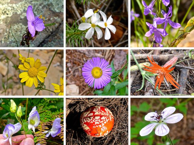
Top Row: pineywoods spiderwort, Nuttall’s linanthus, Apache lobelia.
Middle Row: ragleaf bahia, fleabane, Mexican silene.
Bottom Row: Columbia monkshood, fly agaric, Richardson’s geranium.
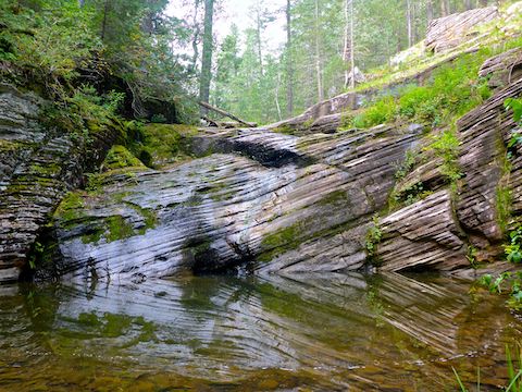
Knoll Lake’s water ran out ¾ mile south of the boat ramp. I aimed up East Leonard Canyon. Normally, I canyon crawl down canyon, climb out, then take forest roads back to my trailhead. Today’s hike showed why.
Though there were sections of animal trail or bracken fern, or even a 200 yd. long meadow, there were several obstacles, and plenty of wait-a-minute vines (as we used to refer to them in the Army). East Leonard Canyon was slow going. It took me 1h 50m — including photos and puzzle solving — to cover 1¾ miles. With the high pre-storm humidity, I was soaked in sweat. 😅
There were also two major obstacles, near the beginning of East Leonard Canyon: The first, a tangle of brush and deadfall that stretched across the narrow canyon bottom. It was steep, so I didn’t relish climbing up and side-sloping. After a few minutes of puzzling out routes, I managed to work my way between the brush pile and the right hand wall. Not 100 yds. past that was the second obstacle.
I figured East Leonard Canyon would start to flatten out, and be less brush-choked, but after 2⅔ total miles, I decided to bail up to FR 9715Q. It was still steep, but using roots and solid looking rocks for steps / foot brakes helped.
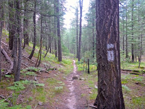
A ⅓ mile later, I turned left onto General Crook Trail, which is marked by reflective white chevrons nailed 8-10 ft. up trees, and spaced every 100 yds. or so. Usually, the next chevron is visible from the one you are standing next to. General Crook Trail looks like an old, pine needle-covered, decommissioned forest road. The easy travel was a relief. 🏹
The General Crook Trail ran from Ft. Whipple, in Prescott, over 200 winding miles east to Ft. Apache, on the White Mountain Apache Reservation. For 43 miles of the middle section, the General Crook Trail is co-located with, or closely parallels, Rim Rd. / FR 300. I was only on General Crook Trail for a little over mile, past dry Lake No. 4, before turning north onto FR 9715J.
I’d been hearing thunder for awhile. While on FR 9715J it began drizzling. No big. After ⅓ mile, I turned right onto an obvious foot trail marked by white blazes shaped like the letter “i”. The blazes marked the unnumbered trail down to, and along, the east branch of Knoll Lake. A little over a mile, the “i” marked trail was the most pleasant part of my day.
I’m not sure what Knoll Lake’s % of fullness is, but it’s low compared to sat view. When I arrived at the southeast finger of the lake, it was crossable dry 200 yds. north of where the satellite shows water 50 ft. wide. When I stopped for a short break, it commenced raining in earnest. ⛈
Where Bear Canyon Lake has an informal trail on its west shore, I had no such luck on Knoll Lake’s east shore. It was slow going, negotiating more rocky slopes, both exposed shoreline, and up in the trees. Moving as fast as my old, fat, ass could, it took me 50 minutes to hike the remaining 1¼ miles back to the boat ramp trailhead. Then it really started pouring.
On my way out, I stopped 200 yds. east of FR 9715J to search for the G.D. Bantz grave. (I would have hiked to it, but was trying to beat the rain.) Afterwards, returning to my car, it was in a ditch, 50 ft. away from where I left it. In drive. Egads. Thank God I did not have my brain fart on the cliff edge of the Mogollon Rim! 😆
Directions: From Phoenix, head north on AZ-87, the Beeline Highway, into Payson. Turn right on AZ-260. In 29 miles, after cresting the Mogollon Rim, take the first left onto FR 300 / Rim Rd. In 3.2 miles, at the Woods Canyon Lake intersection, Rim Rd. changes to car-drivable dirt. 9.4 miles from AZ-260 is a t-intersection. Turn left. (Right is FR 34 to Winslow.) After 11 more miles, turn right onto FR 295. In 3.1 miles, turn right onto FR 295E. Drive past the Knoll Lake Campground, parking near the boat ramp in 1.3 miles.
GPS File: Knoll_Lake_East_Leonard_Canyon_Mogollon_Rim
Distance: 8.15 miles
AEG: 789 ft.
Time: 3h 55m
Hiking Video
Hiking Knoll Lake & East Leonard Canyon from Preston McMurry on Vimeo.