

As you may have sussed, I don’t live in Maryland. (Unless there is a desert I am unaware of in Washington County.) Thus, section hiking the C&O Canal Towpath on weekends isn’t a viable option. Neither is through hiking it, even though it is “only” 184.5 miles from Georgetown to Cumberland. I am, after all, a middle-aged fat man.
So, in 2019, I decided to day hike the C&O Canal Towpath during our biannual trips to visit family in Hagerstown. My plan was to do two 8-12 mile segments on each visit, finishing in Spring, 2025. Then, Chinese Lung AIDs happened. My Easter, 2020, hikes got delayed to Halloween. Trying to make up for lost time, I stretched my next hike from Edward’s Ferry to Noland’s Ferry, got a massive blood blister, and had to cancel my second hike. 🤨
That second Halloween, 2020, from Noland’s Ferry to the Weverton Cliffs, was supposed to be this Easter’s first hike. But it was so cold in Hagerstown before Easter, that I did today’s shorter / closer to town hike first, so I could start later in the morning, when — theoretically — it had warmed up.

When I arrived at Snyder’s Landing, on the outskirts of Sharpsburg, at 9:50, it was 27℉, by three degrees the coldest I’ve hiked. (The Appalachian Trail, on South Mountain, from Crampton Gap to Turner’s Gap.) At least this time I was smart enough to layer up.
MP 77.0: Snyder’s Landing has a small paved parking lot and pit toilet. The boat ramp is 100 yds. further along the road. I did not stop at Barron’s C&O Canal Museum, just around the corner on Mose Circle, as it is only open on weekends. Besides, as cold as it was, eating an ice cream cone would have been perverse. 🚫🍦
I had only been hiking on the C&O Canal Towpath for a few minutes when it became obvious that there were two species of flowers which were loving the freezing temperature: common grape hyacinth and Virginia bluebell. Both were common, the latter moreso, and often found in large patches from Snyder’s Landing until the canal disappears at Big Slackwater.
MP 79.7: Horseshoe Bend Campground is right next to the Potomac River, with an unobstructed view. Camping is free. It has a well hand pump, picnic table, firepit, direction & distance sign, doggie doo bag dispenser and — for humans — a portapotty. The nearest parking is at Taylor’s Landing. For some reason, there is a fancy pants iron rail between the C&O Canal Towpath and the campground.
⅔ of a mile past the campground, on the river side of the trail, a rusty fifth wheel trailer frame is wrapped around a tree. Wrecks are a fairly common find in the wilds of Arizona — heck there are three in the small canyon behind my house! — but that is the first I’ve seen along the C&O Canal. 👨🏻🔧
MP 80.5: Dovenberger’s Mill isn’t listed on any web site I can find, but there was a sign marking a small waterfall, at the corner of Bowie Rd., as such. Bowie Rd. parallels the C&O Canal Towpath for a mile.
MP 80.9: Taylor’s Landing has a pit toilet, doggie doo bag dispenser and room for several boat trailers.
MP 82.5: The well hand pump for Big Woods Campground is located 200 yds. east of the campground (“before” as I hike outbound). Every campground I have seen so far on the C&O Canal, is immediately adjacent to the towpath, but Big Woods Campground, is 100 yds. off the path, behind some trees, adjacent to the Potomac River. It has the usual picnic table, firepit, direction & distance sign, outhouse and doggie doo bag dispenser. Big Woods has the privacy of stealth camping, but none of the illegality.
About a mile past Big Woods Campground, on the canal side of the towpath, I spotted a cave with a steady trickle of water running out of it. The inside of the cave was wet & slippery, so I only went in about 50 yards. 🔦
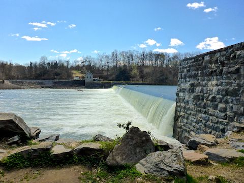
MP 84.6: Dam 4 is heard before it is seen. The original Dam 4 was rebuilt in 1856, after being destroyed by floods. The current hydro-electric gravity dam was built in 1913 and modified in 1994. Dam 4 is 800 ft. across the Potomac River and 20 ft. tall or — more accurately — deep, as none of it shows above the river’s surface. The wooden building over the C&O Canal is the winch house for the stop gate, which prevented river floods from entering the canal channel. The calm waters above Dam 4 are Big Slackwater.
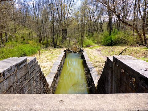
MP 85.5: Big Slackwater Boat Ramp has tons of parking, two pit toilets, multiple picnic tables, grills and doggie doo bag dispensers and … a boat ramp. Of course. 200 yds. past the picnic tables, is Guard Lock 4, its control gate and inlet weir. Together, they allowed boats and water back into the C&O Canal.
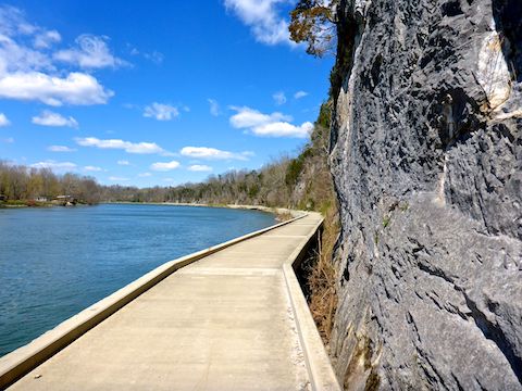
MP 86.6: Big Slackwater was necessary for canal boats to navigate in the Potomac River, as cliffs made digging a canal bed cost prohibitive. However, the boats still needed to be towed, and starting at this point the towpath hugs the cliffs. In 1996, severe flooding wiped out the dirt towpath. From 2010-2012, a new concrete path was built. The wind was strong enough, I could hear waves lapping the underside of the path, like a boat dock. The temp had warmed up to 34℉, but the windchill sucked. 🥶
I don’t like hiking on roads, but the Big Slackwater concrete path was the highlight of my day!
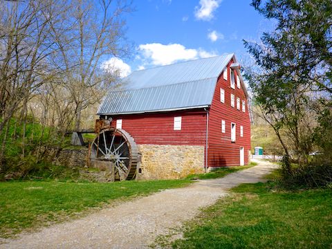
MP 88.1: Just before McMahon’s Mill, there was a stone cabin which — a rarity along the C&O Canal — did not have a history sign. I also spotted the only flower species I saw other than common grape hyacinth and Virginia bluebell. McMahon’s Mill was a large red barn with a water wheel. In back of the mill, across from the small parking lot, Downey Branch was gushing water.
Snyder’s Landing Directions: From Hagerstown, or points east, take exit 29 off I-70 at Sharpsburg Pike MD-65. Head 10.5 miles south to Sharpsburg. Turn right on Main St. In 0.5 miles, turn right onto Snyder’s Landing Rd., which is twisty and narrows to one lane. The trailhead is in 1.5 miles.
McMahon’s Mill Directions: From Hagerstown, or points east, take exit 28 off I-70 at Downsville Pike MD-632. Head 5.5 miles south, through the hamlet of Downsville. Turn right on Dellinger Rd. In 0.5 miles, take the first left onto Avis Mill Rd. The trailhead is in 0.7 miles.
GPS File: CO_Canal_MP77to88_Snyders_Landing_to_McMahons_Mill
Distance: 12.83 mi.
AEG: 289 ft.
Time: 3h 58m
Hiking Video
C&O Canal: Snyder’s Landing to McMahon’s Mill from Preston McMurry on Vimeo.