

The Petrified Forest is a 221,391 acre national park in Navajo County and Apache County, in northeast Arizona. It is known for its fossils, the stunning scenery of the Painted Desert, and its petrified wood. It is a Köppen climate classification system cold semi-arid climate (BSk). About 225 million years ago, the Petrified Forest was a Köppen humid sub-tropical zone (Cfa) on the Equator. In English, it was similar to the area from East Texas to Florida, then north to South Carolina. 🌴
Eventually, the massive trees died and fell into the muck. As the trees’ organic matter decayed, it was replaced by minerals. When the organic matter was gone, what was left were tree-shaped rocks. The tectonic plate drifted north until it eventually settled in northeastern Arizona. In 1906, the Petrified Forest was declared a national monument; in 1962, it became a national park.
Petrified Forest National Park has a program it calls “Off the Beaten Path”, which allows visitors to hike off-trail along certain general routes. (It’s okay to wander, but don’t stray too far.) The last time I hiked Off the Beaten Path, was Onyx Bridge in 2016. Today, I hiked the Clam Beds-Red Basin Loop — except as a figure 8.
The Clam Beds-Red Basin Loop has 11 waypoints along its eight mile length. The trailhead (waypoint 1) is the pullout on left of Blue Mesa Scenic Rd., at the one-way road split. From there, walk ⅓ mile back down the road to the wooden barriers (waypoint 2) on the other side of the road. There’s a fair amount of traffic on Blue Mesa Scenic Rd., so take care on the narrow shoulder.
The wooden barriers are the official start of the Clam Beds-Red Basin Loop. It is 1½ miles on the old jeep trail to the split (waypoint 3), but after a ¼ mile, I turned left up a wide, sandy, wash. (All the many washes on this hike are sandy, varying from smooshy & slow to firm & fast.) Even off-trail as mellow as the Petrified Forest is tiring, so I wanted to do the interesting parts first, easy road walking last. 😉
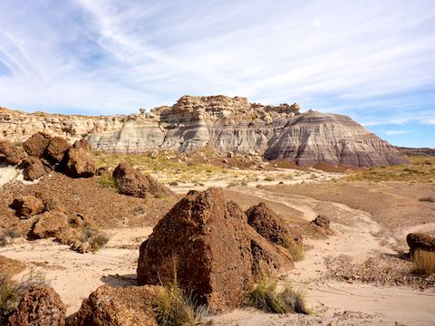
I skirted an off limits area for a mile, before reaching the base of Blue Mesa, which I followed for a ½ mile to the Sandstone Congregate Amphitheater. I’m not a geologist, so I am unsure what the various rock types are, but the congregate seemed to be boulder-size clumps of the smooth sea-bottom pebbles which otherwise cover the whole Blue Mesa – Red Basin – Billings Gap area.
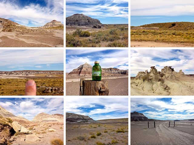
Middle Row: waypoint 7, pointing at old fenceline; hiking beer; Sand Castles at waypoint 8.
Bottom Row: waypoint 9, approaching the massive log; waypoint 10; waypoint 11, at the Billings Gap gate.
From the Sandstone Congregate Amphitheater, I headed east for ⅓ mile to the jeep trail, which I followed south for ¼ mile, crossing the middle of my figure 8 route for the first time. Before reaching Dry Creek Tank, I turned northeast up a wash, towards the Clam Beds (waypoint 4), which were 200 yds. ahead, between the mesa and the left most of two conical buttes. The right butte is waypoint 5. The lone juniper (waypoint 6) was also visible.
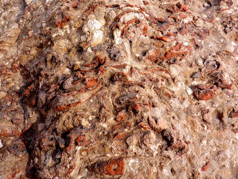
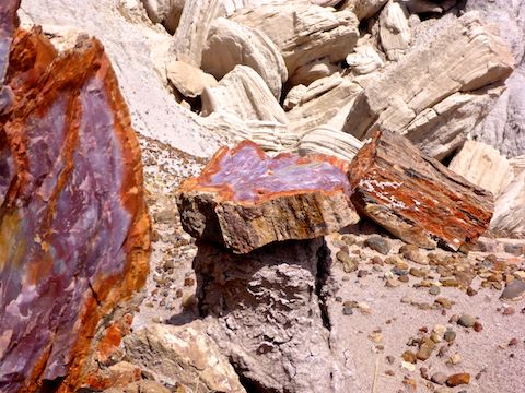
Like the sandsone congregate, the clam shells were densely packed in boulders. Brown and red shells predominated, I guess because the decayed shells were also replaced by mineralization? 🤔
After many Clam Beds photos — I shot over 200 total photos today — I stayed on the official Petrified Forest route, heading left up a 20 ft. saddle between the mesa and the near cone, then turning right towards the second cone. It would have been quicker to head straight towards waypoint 5. (The photos don’t always seem to match the route in the Petrified Forest’s brochure.)
I don’t remember anything special about the second butte (wayp, but as anywhere in the Petrified Forest, even a cursory search will find interesting samples of petrified wood. I aimed left of the lone juniper (waypoint 6), per the brochure’s photo, even though the map seems to indicate going right, around the low ridge. I was in the right area, so not too far Off the Beaten Path. 🧭
On the opposite side of the low ridge is a saddle (waypoint 7), the Clam Beds-Red Basin Loop’s high point. Geographically, anyway. The visual high point, Red Basin, is just ahead. In front of Red Basin, ⅓ mile away, I could see what a fenceline, with what appeared to be tires hanging from it. I aimed for the middle “tire”.
As with every other fenceline on the Clam Beds-Red Basin Loop, no fence remained — just posts. Also, the “tires” turned out to be coils of barbed wire. I followed the posts towards the Sand Castles (waypoint 8), on the edge of Red Basin.
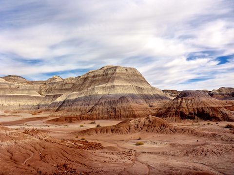
The Sand Castles were interesting, but there are plenty of other sandy, white, hoodoos in the Petrified Forest, particularly a few miles back, with cloudy blue sky high angle backdrop along the upper edge of Blue Mesa. Red Basin, though, is stunning. 😳
Rather than try to cross Red Basin’s purple spurs, it’s easier to follow one of the numerous very twisty washes north from the Sand Castles. Dropping in to the nearest wash was maybe 20 ft. After several very tight turns, where the wash begins opening up, look to your right for a butte beautifully layered with red, orange, lavender, purple, white & tan. Waypoint 9 is ⅓ mile north of the Sand Castles.
The massive petrified log is 150 yds. past waypoint 9, on the right, at yet another abandoned fenceline. I spent 15 minutes marvelling at it, and taking pictures. The petrified log is so massive, it shows on satellite view!
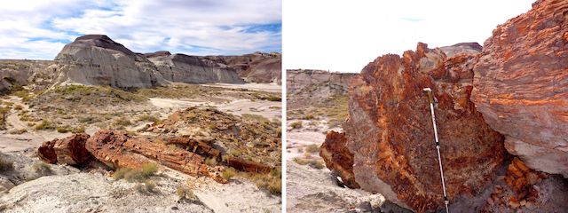
From the massive petrified log, follow the wide wash north-northwest to waypoint 10, which is otherwise unremarkable. Aim for the saddle between the mesa to your left, and the hills to your right. (Actually, ancient sand dunes.) At the top of the saddle, Billings Gap is spread out below. Blue Mesa is on the opposite side of Billings Gap.
From the saddle head down across the rosy brown shoal complex, towards the white sandy wash, following it left around another butte to the Billings Gap gate (waypoint 11), 5½ miles into my Clam Beds-Red Basin hike. Crossing the middle of my figure 8 for the second time, I followed the jeep trail 2½ miles back to the wooden barriers at Blue Mesa Scenic Rd. 🚧
There was actually some muddy spots in the jeep trail. Along it, I spotted the only desert globemallow of my day. The only other flowers I saw were some bushy yellow thing, which were fairly plentiful and may have been goldenrod, and a purple thing that was some variety of tansyaster.
It was a long, but enjoyable day in the Petrified Forest. I really need to get up there more often!
Directions: From Phoenix, drive AZ-87 to Payson; AZ-260 to Heber-Overgaard; AZ-277, AZ-377 and AZ-77 to Holbrook; US-180 17.5 miles to the Petrified Forest; 12.7 miles north on Petrified Forest Rd.; then right on Blue Mesa Scenic Rd. for 1.7 miles to the one-way road split. Park in the pullout, on the left. Leave early: It’s a four hour drive each way.
GPS File: Petrified_Forest_Clam_Beds_Red_Basin
Distance: 9.91 miles
AEG: 389 ft.
Time: 3h 33m
Hiking Video
NEW! Hiking Clam Beds & Red Basin, Petrified Forest from Preston McMurry on Vimeo.