

Normally, my wife & I travel to Hagerstown on Thursday, then return to Phoenix on Tuesday. But because Halloween fell on a Monday this year, we shifted our schedule to fly into BWI on Saturday, then return on Thursday. I intended to hike the C&O Canal on Sunday and Wednesday.
As is quite common, our plans changed. First, I delayed Sunday’s hike to Halloween Monday, due to jet lag. It was raining Monday morning, but back-to-back 10-milers are not in my wheelhouse. I need at least one day in between, preferably two. As it was, trick-or-treating was also rained out. 🚫🧙🏻♀️
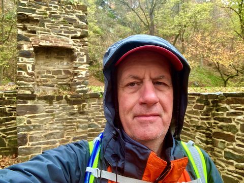
Today, I hiked the 15th of 20 C&O Canal segments, from Cohill Station (MP 130.7) to Fifteen Mile Creek Campground (MP 140.9) in Little Orleans, checking out the Indigo Tunnel bat cave, and other cool stuff along the way. It was wet and chilly — but not raining — when I started hiking at 8:20 a.m.
It quickly became obvious there would be little fall color along the C&O Canal. My feet were actually shuffling through piles of leaves in the towpath. Along most of this segment, the Potomac River is closer than it is downstream. Though it could be because it is late in the year, the brush between the towpath and river is also less dense. I took advantage of the easy access for some Potomac River photos.
MP 133.6: Capacon Junction Campground has the usual C&O Canal “hiker biker campsite” amenities: a portapotty, picnic table, grill, fire pit, direction & distance sign and doggie doo bag dispenser. (Plus a wood bench and plastic chair.) The well hand pump actually had a working handle, which I pumped a half dozen times with no result. You may have better luck with more patience. Traffic on the Gokey Bridge, over the Capacon River in West Virginia, was visible across the Potomac River. 🪕
MP 134.0: Lock 54 is filled in and grassed over. Lock 54 is the first time I recall seeing two channels in a C&O Canal lock — I assume so canal boats can pass going back upstream? A stone foundation is all that remains of Lockhouse 54. For more info, see Locks on the Chesapeake and Ohio Canal.
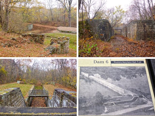
MP 134.1: Lock 55 is only 200 yds. past Lock 54. Lock 55 has easy access to the Western Maryland Rail Trail. Guard Lock 6 is an impressive structure right across the C&O Canal towpath from Lock 55. Guard locks feed water into a canal from water accumulated behind a dam: Unfortunately, the only part of Dam 6 that I photographed was its info sign.
A mile into my hike, it started drizzling. After three miles of sprinkles, the rain grew heavier, but thankfully not a downpour like I experienced back at Great Falls. By the time I reached Sideling Lock 56, the rain had ended. 🌧
MP 136.3: From either end of this segment, Sideling Lock 56 is the halfway point. There’s a WMRT trailhead about ¼ mile before Sideling Lock 56, but I don’t recall seeing any easy access. (It’s through 75 yds. of brush on the landward side of the C&O Canal.) Otherwise, Sideling Lock 56 can be used for an informal pickup. There’s a canoe rental across Pearre Rd. Lockhouse 56 is extant, but … ah … locked up.
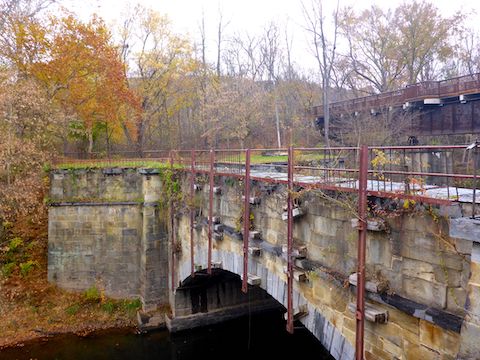
MP 136.6: Sideling Hill Creek Aqueduct is one of the shortest on the C&O Canal at 110 ft. long, with a single asymmetrical 60-foot arch. Completed in 1850, the aqueduct was built with Tonoloway Limestone, Pocono Sandstone fill from Sideling Hill, and cement from Round Top Mill and Leopards Mill. If I had realized there are brick kiln ruins just downstream, I would have checked them out.
MP 137.9: Below a rocky 400 ft. bluff, the Western Maryland Rail Trail merges into the C&O Canal towpath at Turkey Foot Bend. The rail bed continues to the east portal of Indigo Tunnel. (Pictured in the video thumbnail, below.) 🚂
As the C&O Canal rounds Indigo Neck, it becomes wide & shallow. Not watery, and with firm footing, I crossed the canal to check out the fallow field on the other side. Someone once farmed it, but there is nothing there now.
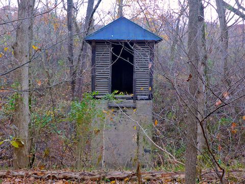
MP 139.4: Lock 57 and Indigo Neck Campground. There is a portapotty, picnic table, grill, fire pit, direction & distance sign and doggie doo bag dispenser. Like a few miles earlier, the well hand pump had a working handle. I didn’t need the water, as I was carrying my Camelbak. Lockhouse 57’s stone foundation, and most of its chimney, is still standing. I’d be tempted to camp in it.
MP 140.3: I expected an obscure, brushy, foot trail to Indigo Tunnel. But I needn’t have worried as it is not only obvious, but landscaped. There’s actual planted trees! Just follow the steel & cement bridge where the WMRT departs from the C&O Canal towpath. The west portal is 100 muddy feet from the WMRT. As I approached, I heard — but did not see — several bats, despite Indigo Tunnel being Maryland’s largest known bat refuge. 🦇
MP 140.9: I intended to end my hike with a hiking beer at Bill’s Place in Little Orleans, but they are only open Thursday-Sunday, and today was Monday. Instead, I met my wife at Fifteen Mile Creek Campground. There’s a free hiker / biker site on the west side of the aqueduct, but the east side costs for car campers. There is a boat ramp, two pit toilets, four picnic tables and nine sites (each with a grill, firepit and another picnic table).

Cohill Station Directions: From I-68, take exit 77. Turn left onto MD-144 / Western Pike. In 1.1 miles, turn right onto Willow Rd. In 2.8 miles, turn left onto Seavolt Rd. In 1.1 miles, take care of the 1-lane underpass. In 200 yds., when the road curves right, park in the left side pullout.
Little Orleans Directions: From I-68, take exit 68 onto Orleans Rd. south. Mind the free range turkey 1.3 miles south of I-68. 5.8 miles south of I-68, make a sharp left onto High Germany Rd. Pass by Bill’s Place, through the 1-lane underpass. Turn right into Fifteen Mile Creek Campground. There is no fee for simply parking.
GPS File: CO_Canal_MP130to140_Cohill_Station_to_Little_Orleans
Distance: 12.42 mi.
AEG: 311 ft.
Time: 4h 00m
Hiking Video
C&O Canal: Hiking Cohill Station to Little Orleans from Preston McMurry on Vimeo.