
 had eight bluff-side kilns, which I would have used for shelter if it started pouring.")
Sunday, was my 60th birthday dinner at Schmankerl Stube Bavarian Restaurant, which I’ve been wanting to try for years, as it was founded by an actual Bavarian, with an executive chef who is also Bavarian. Why Bavarian in Hagerstown, Maryland? Because Hagerstown’s German history dates back to it’s founding in 1762 by German immigrant Jonathan Hager.
Monday, it was time to work off the wurst by hiking the 14th of 20 C&O Canal segments, from Hancock to Cohill Station. Hancock is a “trail town”, complete with a canal-side bicycle shop (C&O Bicycle). Cohill Station, is a just a name on a map for what was once a Western Maryland Railway siding. (Probably similar to the Harqua siding, west of Phoenix.) In between, I hoped to find more cool canal stuff. 📸
I started hiking the C&O Canal from the Hancock Boat Ramp at 8:10 a.m., almost an hour earlier than planned, due to rain being expected late morning all across Washington County. Even though I was not bike riding, I still wore my Camelbak, and good thing too as it was 94% humidity!

Before I even reached the US-522 bridge to West Virginia (MP 124.6), it was obvious the C&O Canal would have more flowers between Hancock and Cohill Station than it did between Fort Frederick and Hancock. Unfortunately, besides threatening to rain later in the morning, it had rained the night before, so every time I stopped I got swarmed by mosquitoes. At least the towpath drains well.
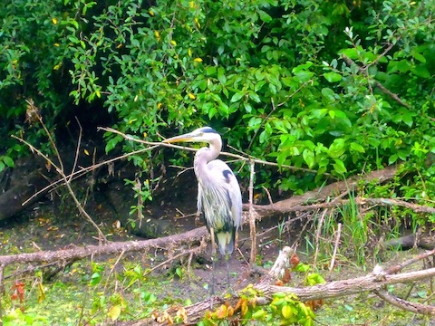
There were quite a few lilypads in the C&O Canal before US-522. Just past the bridge, I spotted a great blue heron. Five minutes after that, where the canal bed began choking up with brush and trees, I saw two whitetail deer, one a young buck: No spikes, just fuzzy pegs a few inches long. 🦌
Maryland is home to 27 species of snakes. Of the two dangerously poisonous species, the timber rattler population is declining, but found in western Maryland, where I was hiking. Eastern copperhead — the other poisonous snake — is found in exactly the sort of terrain along the C&O Canal (forests, old fields, swamps). Aways a concern in Arizona, I never think about snakes in Maryland.
Berm Rd. closely parallels the north side of the C&O Canal for 1½ miles. There is no potential bail point until almost five miles later at Cohill Station.
MP 126.5: White Rock Campground has the usual handleless well hand pump, portapotty, picnic table, grill, fire pit, direction & distance sign and doggie doo bag dispenser. Camping is free, and I saw a bike tourist taking advantage of the site. I was surprised he was still in his tent at 9 a.m.
Somewhere along the way, I stepped off the C&O Canal towpath into the what appeared to be a firm, or at least not watery, canal bed. I immediately sank into 4″ of mud. 🙄
Round Top Hill (1,358 ft. el.) is a stand-alone ridge that stretches two miles south-southwest from MP 127.2 to near Leopards Mill Campground. It is exceptionally steep at its northern end, above Devil’s Eyebrow, climbing 950 ft. in only ¼ mile (a 38% grade). As I approached Round Top Hill, the upper ⅔ was shrouded in low-lying clouds.
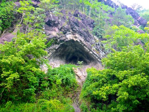
MP 127.4: The first feature of Round Top Cement Mill I noticed was the stone-faced kilns 30 ft. up on the bluff-side of the canal. Trying to beat the rain, I skipped exploring the kilns like I did back down the C&O Canal near Dargan Bend.
Round Top Cement Mill, in operation from 1838 to 1903, provided cement for the construction of the Washington Monument — the one in DC, not the original along the Appalachian Trail — and the U.S. Capitol building being most prominent. My hike video (below), shows Round Top Cement Mill as it was back in the day; this blog’s banner (above) shows it as it is now. 🏭
MP 128.0: Precisely at the white-on-brown painted wood marker is a ground-hugging cement structure with heavy iron bolts. No clue what it was, maybe a culvert?
Midway between Round Top Cement Mill and Leopards Mill Campground, there’s at least a mile-long stretch of the C&O Canal filled with green water, which always makes for interesting contrast photos with half-submerged logs.

Top Row: Phlox paniculata, white bergamot, dame’s rocket.
Middle Row: European black nightshade, Japanese wineberry, Carolina vetch (???).
Bottom Row: crown vetch, mold and a bonus nightshade.
The Maryland Biodiversity Project is a great resource!
MP 130.0: Camping at Leopards Mill Campground is free. The campground has a portapotty, picnic table, grill, fire pit, direction & distance sign, doggie doo bag dispenser and … DRUM ROLL! … the first functional water pump in over 20 miles. No joke. I’m serious. Cross my heart and hope to die, stick a needle in my eye. 🤞
Irishman’s Lock 53 is just past Leopards Mill Campground and is the first C&O Canal lock I remember that is impassable due to dense brush. The canal sure, but not any lock I recall. Irishman’s Lock 53 also had some foundation and cement steps that appeared to be lockhouse remains. For more info, see Locks on the Chesapeake and Ohio Canal.
MP 130.7: I arrived at Cohill Station just as a light sprinkle began. There’s a boat ramp to the left, but a narrow footbridge to the right, so the only “boat” getting across that is a kayak. Parking is in a pull out just across the bridge.
Hancock Directions: From I-70, take left-lane exit 3 west onto Main St. / MD-144. In 1.6 miles, in the middle of downtown Hancock, turn left onto Pennsylvania Ave. At C&O Bicycle, turn right onto Berm Rd. Take the next left, across the C&O Canal. Park in the Little Tonoloway Day Use Recreation Area.
Cohill Station Directions: From Hancock, continue west on Main St., under the US-522 bridge. In 1.5 miles, turn left on Round Top Rd. In 3.3 miles, make a slight left onto Willow Rd. In 1.6 miles, take care of the 1-lane Maryland Rail Trail underpass. In 200 yds., when the road curves right, park in the left side pullout.
From I-70, take exit 77 south. Head east on Western Pike / MD-144. In 1.1 miles, turn right onto Willow Rd. In 4.4 miles, take care of the 1-lane Maryland Rail Trail underpass. In 200 yds., when the road curves right, park in the left side pullout.
GPS File: CO_Canal_MP124to130_Hancock_to_Cohill_Station
Distance: 6.98 mi.
AEG: 125 ft.
Time: 2h 14m
Hiking Video
C&O Canal: Hiking Hancock to Cohill Station from Preston McMurry on Vimeo.