

Gradually transitioning from bike riding, I didn’t become a regular hiker until 2011. That was also the year I did my first Mogollon Rim hike, from Geronimo Trailhead to Washington Park. I need to re-hike that soon, as that was before my first hiking video.
The Mogollon Rim is a 200-mile long escarpment, extending from Yavapai County to New Mexico. Up to 2,000 ft. above terrain, the Rim separates the low desert of central Arizona from the higher elevation Colorado Plateau in the northern third of the state. At 7,800 ft. elevation between AZ-87 and Willow Springs Canyon, it’s a great getaway from the heat in Phoenix. 🌇
I did a couple of Mogollon Rim hikes every year, but in 2018 I got serious about hiking every named canyon between AZ-87 and Willow Springs Canyon. I plan to do eight Mogollon Rim hikes this year. First up in 2021, Bear Canyon Lake.
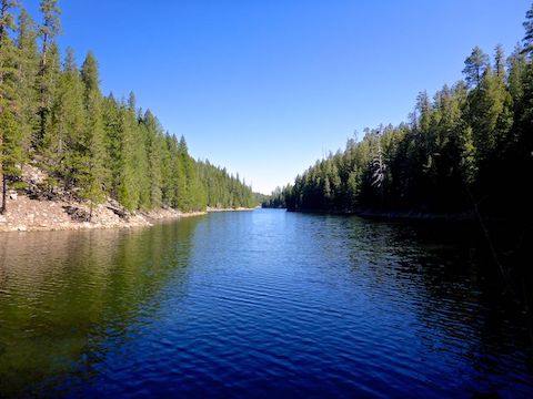
Bear Canyon Lake is a mile long. It is 250 yds. at its widest point, 200 ft. at its narrowest. At 60 acres, Bear Canyon Lake is slightly larger than Woods Canyon Lake.
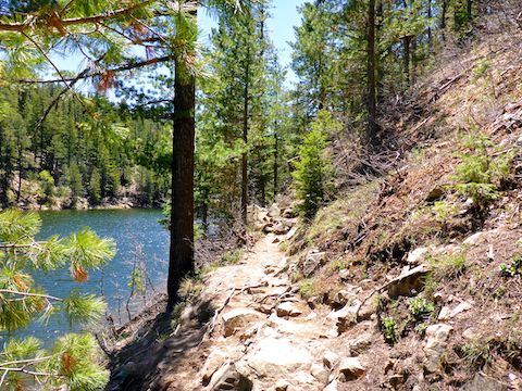
Officially, Bear Canyon Lake Trail #112 is about 1¾ miles long, from the dam at the lake’s north end south to the trailhead on FR 208, where I started. At least that is the part blazed with blue plastic diamonds. (If you see a white diamond, it’s still Trail #112, just faded from blue.) Informally, the trail continues around the east side of Bear Lake. 🧭
Besides FR 208, Bear Canyon Lake has two other trailheads — Mallard TH and Merganser TH — that are accessed via FR 89 and Bear Canyon Lake Rd. / FR 89A. FR 89 may be car drivable, but is much rockier than FR 208. On the other hand, there are three pit toilets on FR 89A. (Though they were still locked for Covid-19.) Each trailhead is a short, but steep, descent to Bear Canyon Lake.
Since a loop around Bear Canyon Lake is only 3.5 miles and 300 ft. accumulated elevation gain (AEG), I planned to also explore the two drainages which feed the lake: Up Bear Canyon to its southwest, then down the unnamed wash to its southeast. Starting at 8:45, I told my wife I’d be back about 11:30.
The trail descends a steep & fairly rocky 180 ft. in a ¼ mile to a open area on the south shore of Bear Canyon Lake. I hiked counter-clockwise, to take photographic advantage of the morning sun. There was water in the southeast drainage, but I crossed it dry. Turning north, I edged past a couple guys fishing for rainbow trout. 🎣
The unnumbered trail on the east side of Bear Canyon Lake does get indistinct at times, but generally speaking is within 30 ft. horizontal and 10 ft. vertical of the lake surface. Sometimes the trail is right next to the lake, literally within inches. It’s not a scramble, but I took care negotiating rocky outcroppings to avoid a wet tumble.
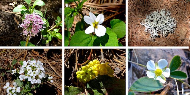
Top Row: Arizona valerian, Canadian white violet, lichen.
Bottom Row: alpine pennycress, unknown, woodland strawberry.
The Mogollon Rim got snow just a week ago, so I was not expecting a good flower hunt. I was happy I found what I did. Spotted along the middle third of both banks of Bear Canyon Lake, Arizona valerian was the only flower I noticed in more than one place. I found about nine species, all told. Lichen were common though.
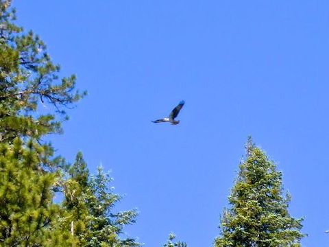
While I was hiking up the east side of Bear Canyon Lake, I saw an Arizona DPS rescue helicopter, no more than 500 ft. up. He did a lap and a half around the lake, then disappeared. My wife said later she worried he was looking for me! 🚁
I got to the dam at the north end of Bear Canyon Lake at 10:30. Hiking the east side took longer than I expected. I knew I wouldn’t have time to explore the drainages and be back to FR 208 by 11:30. (My wife had an early flight on Friday, and I wanted to be considerate, as she makes so many of my hikes possible.)
Halfway south on Bear Canyon Lake Trail #112, there was some kind of rope & stick contraption tied to a tree. It looked like a booby trap, but I’m sure it was a rope swing. Despite being more distinct, there were still a few places where you could lose Trail #112. If you stay within 50 ft. horizontal and 30 ft. vertical of Black Canyon Lake, and look for the next blue diamond, you’ll be okay.
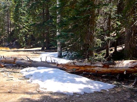
When I arrived back at the south end of the lake, it was already after noon. It was unseasonably warm for the Mogollon Rim — 81° on Rim Road an hour later — so imagine my surprise at finding snow along the bank of the creek. Schweet! 🤗
My wife & I stopped at Fatso’s Pizza on way home, to pickup dinner and knock off the sweat with an ice cold Pabst. Fatso’s is a casual neighborhood place, not a dive bar. While waiting, the weirdo next to me was talking to himself. Not just one muttered curse at a strikeout on the TV, but a whole conversation. I swear, if Milton had mumbled about his red Swingline stapler I would have lost it!
Directions: From Phoenix, head north on AZ-87, the Beeline Highway, into Payson. Turn right on AZ-260. In 29 miles, after cresting the Mogollon Rim, take the first left onto FR 300 / Rim Rd. In 3.2 miles, at the Woods Canyon Lake intersection, Rim Rd. changes to car-drivable dirt. 9.4 miles from AZ-260 is a t-intersection. Turn left. (Right is FR 34 to Winslow.) In 2.3 miles, just past the Promontory Fire Lookout Tower, turn right onto FR 208. (FR 89 is another mile.) In 1.8 miles, park at the FR 208 Trailhead.
GPS File: Bear_Canyon_Lake_Loop
Distance: 5.79 mi.
AEG: 556 ft.
Time: 2h 41m
Hiking Video
Hiking Bear Canyon Lake, Mogollon Rim from Preston McMurry on Vimeo.