

Friday is my normal hiking day. That gives me all weekend to work on the resulting photos, video & blog, and have the whole thing ready for you to enjoy with your coffee as soon as you show up at work on Monday morning. 😉
Because my favorite comedian, Dave Landau, was going to be appearing at Laff’s Comedy Caffe in Tucson on Friday evening, I booked a hotel for two nights, drove down on Thursday afternoon, and went for a hike on Friday, before the show.
I’ve never hiked in Tucson before, or anywhere near it. The closest would be Aravaipa Canyon, an hour northeast, which might as well be on a different planet. 🌎
In fact, I’ve never hiked anywhere in Arizona south of the Gila River, near Safford, which is a four hour drive from Phoenix. And that is why I’ve avoided southern Arizona: It’s just too far. I can’t get there and back, and get a decent hike in, in one day. I have to get a hotel and push my production schedule out into Tuesday.
The coolness of the Mogollon Rim is more accessible than the Pinaleno Mountains or Galiuro Mountains, let alone ranges further afield like the Huachuca Mountains or Chiricahua Mountains. (Though I did do a 10k ruck run at Fort Huachuca when I was in ROTC in the late 80s.)
Even the Santa Catalina Mountains, which tower over Tucson, are at least a two hour drive from my home in the shadow of Phoenix’s North Mountain. Longer, if I get stuck behind some tool doing 20 under in the passing lane on I-10.
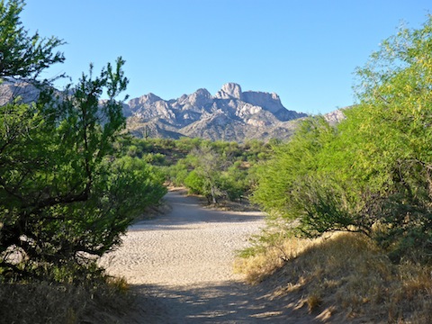
The hike to Romero Pools starts from the Romero Canyon Trailhead, at the far end of the park road. The trailhead has a really nice, shady picnic area that even when it as 92° at noon was still comfortable.
From the trailhead, cross the road towards a ton of trail signs. (Many trails start from Romero Canyon Trailhead.) Cross Sutherland Wash then, at the Birding Trail, turn left. There’s a short, steep, climb that reminded me alot of the access road at Shaw Butte.
The middle of Romero Trail #8 alternates between sandy and firm. In the sandy spots, the edges are usually firm, so no need to struggle with a slippery surface. It is wide, like a recovered old jeep trail more than a hiking trail. Rather than single track, it’s more like quadruple track.
A half mile into the hike, Canyon Trail splits left. Go right.
At 0.9 miles, Montrose Pools Trail splits right. Go left.
The first mile of Romero Trail #8 is a mellow stroll through a healthy mesquite forest. I don’t recall ever seeing so many mesquite before. Nearly all the ocotillo were blooming, though not the saguaro.
After the Montrose Pools trail, you enter the Pusch Ridge Wilderness, which is protected Big Horn Sheep habitat. No dogs or horses are allowed. 🚫🐶
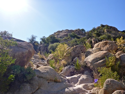
Romero Trail #8 becomes single track, steadily climbing, 800 ft. in a little over a mile, to the hike’s high point overlooking both Romero Canyon and Montrose Canyon. The first climb is staired, with railroad ties. The other climbs are rocky stepups. The climb would have been much easier without all the knee lifts. It reminded me a lot of the Ballantine Trail. The short flat sections scattered along the climb were a relief.
In the early morning, on my way out, much of the climb was in shadow. Just before noon, on my way back, when it was hot, there was no shade at all. I had to use my sweat rag as a keffiyeh to keep the sun off my neck.
There was a steady stream of folks heading up to Romero Pools, most of whom passed me as I went nuts shooting #flowerporn.
Finally!
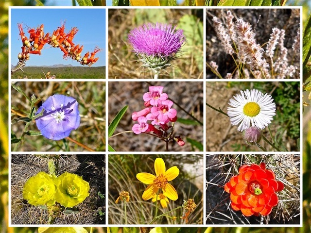
Middle Row: No clue.
Bottom Row: Prickly Pear, ??? and Claret Cup Cactus.
Prior to today, I had seen a grand total of five flowers on three Arizona spring hikes. 😕
I’m no botanist, but besides the ocotillo, I spotted Mexican Gold Poppy, Claret Cup Cactus, New Mexico Thistle and at least a dozen other species. The prickly pear cactus were going nuts! Bright yellow flowers so big, some were the size of grapefruit!
One of the prickly pear blooms was host to a small, spindly, pale green, almost translucent, spider. I got a photo, but the video was blurry. At Upper Romero Pools, a bigger spider was hopping across the rocks. That gave me a start, until I realized he didn’t want to eat me. I think. 🍽
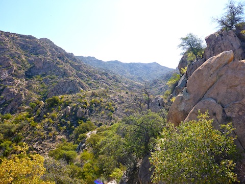
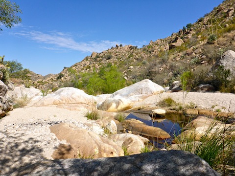
From the saddle, Romero Trail #8 drops about 200 ft. to Lower Romero Pools. I skipped them, as there were other folks already there.
Instead, I hiked across a small meadow to the Upper Romero Pools. I took a break at a shady campsite, before commencing an orgy of photography and videography. I spent so long at it, I ran out of time for a relaxing foot soak. (I don’t know about Lower Romero Pools, but the upper were not deep enough for any more than that, certainly not diving!)
The only flowers I saw at the Upper Romero Pools were clinging to the rock face of a small pour. There were a number of small riparian areas, at one of which I saw what I can only describe as large, hairy, orange dragonflies. They certainly were not caterpillars, as they were actually flying. Let me know what you think those bugs might have been. 🤔
On the way out, I passed several groups hiking in, some of which only had a bottle of water each, and during the hottest part of the day. Stupid.
Just above the Lower Romero Pools, I lost my glasses while bending over for yet another flower photo. I didn’t realize they were missing until I was on the downside of the saddle. Not wanting to hike back down, then up again, and spend time searching with dwindling water, I settled for asking more alert looking hikers if they could keep an eye out for my glasses — pun not intended — and if they found them, to drop them off at the ranger station. (I checked the next morning: No one had turned my glasses in.)
Forgetting there was a case each of water and G2 in our SUV’s survival box, my wife had asked for a water before I left. Likewise being forgetful, I didn’t hesitate to give her one from my pack. I wasn’t risking heat stroke, but I sure could have used that water on the way back. It was a lot warmer at 3,000 ft. than I expected. Making matters worse, I had left my salt & potassium rich post-hike V-8 back at our hotel. (Resulting in cramps after the Dave Landau show.)
Back at the Romero Canyon Trailhead, while I drank the last of my pack liquids, other than the warm Guinness, I chatted with a couple from Chicago that were preparing to hike up to Romero Pools. Unlike earlier hikers, they came prepared.
Directions: From the Loop 202 South Mountain Freeway in Phoenix, there are two options: Take I-10 through Casa Grande or AZ-79 through Florence. The distance is essentially the same. I opt for AZ-79, as even though it is mostly two lane highway, there is less traffic and therefore less stress. To continue on I-10, head south for 79 miles to Exit 240. Head east on Tangerine Rd. for 13.5 mi. Turn right on AZ-77 / Oracle Rd. In 0.7 miles, turn left into Catalina State Park. There is a $7 entrance fee. In another 1.5 miles, park at the Romero Canyon Trailhead.
GPS File: Romero_Pools
Distance: 7.23 miles
AEG: 1,582 ft.
Time: 3h 18m
Hiking Video
Hiking to Romero Pools, Santa Catalina Mountains from Preston McMurry on Vimeo.
I wish I could have gone to the pools.