

I’m gradually working my way through the many small canyons that drain off the Mogollon Rim, one or two per year:
East Bear Canyon (2014) was loaded with ferns on both legs. It was mostly mellow walking, with a short, steep hike out of the canyon, followed strolling back to the trailhead along a jeep trail (and more fern patches).
West Bear Canyon (2014) is known for having great fall color, usually the last day or two of September. I’d be going back there in a few weeks, except my wife & I had to move up our annual Flagstaff fall trip because the bed & breakfast we usually stay at, The Inn at 410, was full the first weekend in October. I’ll try again for West Bear in 2018. 🍁
Pivot Rock Canyon (2015) had a defined trail from Pivot Rock Spring, past the Pivot Rock and the old cabin to Hicks and Duncan Canyon. The unnamed side canyon I took back up was not smooth sailing, but neither was it choked with boulders and deadfall.
East Miller Canyon (2016) started out mellow, but got very tangled and physical. The video I did for East Miller does not adequately convey how rugged it got. My Crackerbox Canyon video will correct that mistake.
I had not been on AZ-260 since the late 80s, when I was coaching youth football in Flagstaff, and I drove from a game I scouted in Payson to one my team was playing in Cottonwood. So, rather than my usual route up the Beeline Highway, I weaved through traffic up I-17, then headed east on AZ-260. There’s a lot less traffic on AZ-260 east of the Verde Valley, than there is north of Payson on AZ-87. We made it to Rim Rd. in 90 minutes, or about 30 less than we otherwise would have. No gas stations or rest stops along AZ-260 though, unless you count bushes.
Driving the west end of Rim Rd. is a pain in the ass — literally, with all the bumps — and it took us 45 minutes to drive the final 12 miles to Crackerbox Canyon.
My pre-hike satellite recon found a good place to park on FR 391, just off FR 141H. I could ‘combat park’ — nose out for quick getaway — my SUV, in shade, out of sight of passing traffic on the ‘main’ road. That meant more safety for my vehicle and, more importantly, my wife who accompanies me on my trips, but not the actual hikes.
Crackerbox Canyon most closely resembles it’s next door neighbor, East Miller Canyon. (Crackerbox actually drains into East Miller and, eventually, East Clear Creek.) I’ve always found it odd that the Mogollon Rim mostly drains north, gradually downslope, rather than tumbling south, over the cliff, in spectacular waterfalls. The Mogollon Rim is the continental divide of Arizona.
The hike starts out by heading back down FR 391 for a hundred yards to FR 141H, then east down FR 141H for not quite a half mile. The low point in the road is Crackerbox Canyon.
Many of the canyons the various roads cross are signed, as is East Miller Canyon, but Crackerbox is only signed on Rim Rd., not FR 141H. Turn north off FR 141H across the small meadow.
Once you are in Crackerbox Canyon, you simply follow it north for 4.7 miles to the intersection with East Miller Canyon.
The first three miles, to the barbwire fence, are very mellow travel. For me, the creek bed was totally dry. There are often shelves on either bank. There is minor dead fall here & there, but it is easily avoided by switching to the other bank, or walking for awhile in the creek bed. The first couple of miles would make a great introduction to canyon hiking for kids.
If you do hike with kids, or don’t relish low crawling, in the dirt, under large logs, there’s a good bail out point about 2.5 miles down Crackerbox Canyon, where there is a good size meadow of ferns and false hellebore on both the east and west bank of the wash. (False hellebore resemble corn stalks.) Head west, across the meadow, and uphill 100 ft. to FR 501, following that back to the trailhead.
Crackerbox Canyon starts out so mellow, because it is shallow and it’s cross section flat. The barbwire fence is easily crossed. North of the fence, Crackerbox gets deeper (about 200 ft.), narrower, with steeper slope.
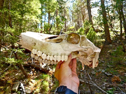
Like East Miller Canyon, Crackerbox has tons of elk sign, both scat & bones. I saw a vertebra and leg bone south of the barbwire fence. Just north of the fence, I found a nearly intact skull. Some of the skull’s structures had needle sharp points. I wrapped the skull in a mylar balloon I had picked up, then stuffed it in my pack. Sweet find. No way I was leaving it behind!
The large rocks and, later, boulders in Crackerbox Canyon tend to have smoother edges than the small rocks lining the wash bottom, which tend to have sharper edges. That would seem to be indicative of infrequent flooding to provide the necessary tumbling & polishing.
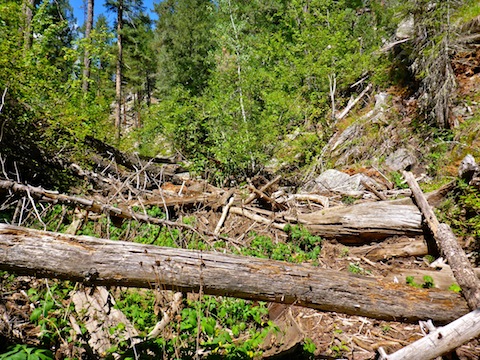
North of the barbwire fence, Crackerbox Canyon is frequently choked with deadfall and boulders. On rare breaks from crawling over, or under, an obstacle, there is running water or good size pools. You will not only get dirty, but wet as well. I wouldn’t want to be caught in there if there was a flash flood.
As a result of negotiating Crackerbox’s obstacle course over the final 1.5 miles, I acquired my usual array of scrapes, bumps & bruises.
It was a relief to reach the junction with East Miller Canyon after three moving hours. (Plus an hour of photos, GPS consultation, etc.) I took a sit down break on some rocks, enjoying a sandwich, vinegar chips — my fave! — and G-2 sports drink.
After lunch, I looked up at the bluff. It was rocky, and steep, but not sheer like much of the previous 1.5 miles. It looked like there were a couple of routes up. I picked one, that turned out to be a bit of a water channel. It ended up taking me only 15 minutes to get to the top.
Crackerbox has plenty of shade, so I was sweating more from the labor than the temps. Thankfully, the trek back south on FR 501 also had plenty of shade. It was also breezier on top. I thought I smelled smoke, or maybe cooking food.
At first, FR 501 was barely detectable. It was mostly grass. It was only after reaching the gateless barbwire fence — a continuation of the same fence down in Crackerbox Canyon — that I realized why FR 501 was so indistinct: It is being returned to nature. South of the fence, FR 501 was normal jeep trail.
I heard, but did not see, wild turkey at Jiffer Tank. Just north of Tracy Lynn Tank, I saw a camper, which would explain what I had smelled three miles earlier.
From the top of the bluff, it is 4.3 flat, shady, miles south on FR 501 to FR 141H, then only another .40 miles east to FR 391 and the trailhead.
Directions: From Phoenix, head north on AZ-87, the Beeline Highway, through Payson, Pine and Strawberry. (Alternately, take I-17 north, then AZ-260 east.) 2.6 miles north of AZ-260, turn right onto Rim Rd. / FR 300. Rim Rd. is dirt and, at its western end, twisty and very bumpy. I would not do it in a car. In 11 miles, turn left onto FR 123. Take the very next left onto FR 141H. You will cross Crackerbox Canyon. You can park there, or continue to the next right onto FR 391. (Out of site of the ‘main’ road, means more security for your vehicle.)
GPS File: Crackerbox_Canyon_Loop
Distance: 11.60 mi.
AEG: 749 ft.
Time: 4h 55m
Hiking Video
Hiking Crackerbox Canyon, Mogollon Rim from Preston McMurry on Vimeo.