

This is my seventh Loop 202 South Mountain Freeway survey hike. I’ve done them every six months or so since April, 2015, when the freeway’s path was finalized. (Some options had it going way west of Maricopa and the Gila River Indian Community, or roughly where I-11 will probably end up going.)
These survey hikes document the changes at the west end of South Mountain Park, between Pecos Rd. and the Dusty Lane community, adjacent to the Vee Quiva Casino. The freeway will be much longer than the four miles or so I have been recording, 22 in all, first replacing Pecos Rd., then angling along the east side of the power lines next to the Gila River Indian Community, then heading north along the former path of 59th Ave. to I-10.
As of January, 2018, ADOT’s Loop 202 South Mountain Freeway site indicates that the Center Segment, the part I survey, is currently scheduled to begin construction by the Spring of 2018. Which is now. See the orange bit below:
When I did my last survey hike, almost six months ago, there had been no changes anywhere along the Loop 202 South Mountain Freeway’s Center Segment. (Unless you count someone whitewashing the Graffiti Ranch, which is actually on private land.)
However, looking about a mile northwest from 51st Ave. and Dusty Lane, I could see work being done at 59th Ave. and Estrella Dr. Earth had been piled up and work begun on an interchange at that location. The original Loop 202 South Mountain Freeway plan was to have that interchange at 51st Ave. and Dusty Lane. But no plan survives first contact with the enemy. Or something like that. In any case, the plan changed, I’m guessing because of 59th Ave. and Estrella Dr. is a much less complicated area to work in. It was all farm fields. Whereas, 51st Ave. and Dusty Lane is just north of the Vee Quiva Casino, it’s right where the power lines cross the road (probably the biggest factor), and the people in Dusty Lane that did not get eminent domained still need access to their homes.
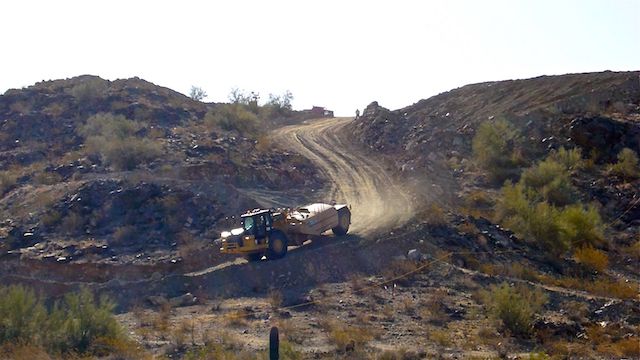
Now, that work has moved southeast from 59th Ave. and Estrella Dr. to 51st Ave. and Dusty Lane. Approaches to what will now be an overpass have had earth ramped up, and the first concrete support pillars are in place. There’s all kinds of orange cones & caution signs on either side of the future overpass.
I did not see any changes in Dusty Lane itself: The condemed homes were torn down and the land scraped clean sometime early in 2017. There’s plenty of easy access for construction vehicles, so no earth had been moved in the community.
South of Dusty Lane was a different story.
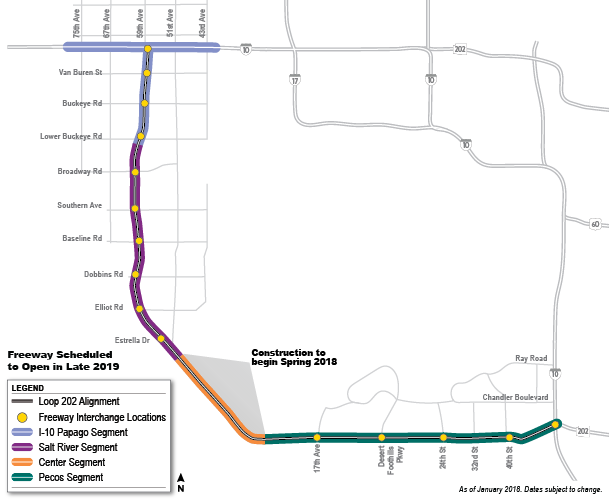
A construction vehicle access road had been plowed from the south end of Dusty Lane up the north slope of Main Ridge North, and a water tanker refilling station & reservoir put in near multi-use crossing #3 (or waypoint #17 on the GPS file attached below). I later found similar reservoirs at waypoint #9 (the west end of the new luxury development) and waypoint #1 (the pump station on Pecos Rd.).
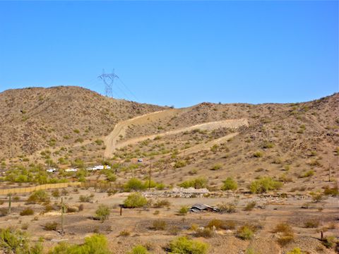
For what it is worth, the new luxury development, being built by Taylor Morrison, is formally known as The Promontory at Foothills West Summit Collection Community. Quite a mouthful. More words obviously means more luxury. 🤑
“Waypoints” are the locations of the photographs I took every 1/10th of a mile along the Loop 202 South Mountain Freeway right-of-way, to document the changes as they gradually occur. But once it became difficult, or possibly illegal, to do so, I would instead parallel the right-of-way.
Paralleling became necessary on this trip. Rather than head up Main Ridge North, to the power tower that was waypoint #16, I instead headed for the National Trail, at a small pass at the east end of Main Ridge North, then down to the Graffiti Ranch.
There is a small, unnamed, ridge that partially separates the Graffiti Ranch and Stone Wall Ranch from Main Ridge South. The R.A. Steele Ranch is at the western tip of that unnamed ridge. From a vantage point about a quarter mile east of R.A. Steele Ranch, I could see the three ranches, the luxury development, the south slope of Main Ridge North, the valley, and the north slope of Main Ridge South.
I counted twelve homes under construction in The Promontory at Foothills West Summit Collection Community luxury development. Apparently, some are already complete and ready for sale for the low, low, price of only $600,000. Or more. Notice how Taylor Morrison’s promo video avoids mentioning the freeway which will be serenading the occupants. 🤫
The ruins of the R.A. Steele Ranch, which will be under the Loop 202 South Mountain Freeway’s northbound lanes had not yet been erased. There is a construction vehicle lot near the ruins of the Stone Wall Ranch, which looks to be just outside the right of way.
The construction vehicle access road switchbacks down Main Ridge North, crosses the valley yards east of the R.A. Steele Ranch, passes within 100 yds. of the luxury development, then switchbacks up Main Ridge South. In the valley, and at either end of the Center Segment, the entire right-of-way is delineated by yellow rope. There were no “Do Not Enter” signs, except on the fences surrounding the water stations. There were also many yellow ropes running at odd angles to the right-of-way. Maybe those were marking future culverts or multi-use crossings? 🤔
I saw many black on white “NOTICE: Waters of the U.S.” signs. There’s no water anywhere at the west end of South Mountain Park. (There’s a jillion washes though.) I wonder what the signs mean?
I also spotted a wood pole marked “Sensitive Area”. That was odd, because prior to construction beginning on The Promontory at Foothills West Summit Collection Community luxury development the valley was nothing but waste land. No petroglyphs, like near waypoint #4.
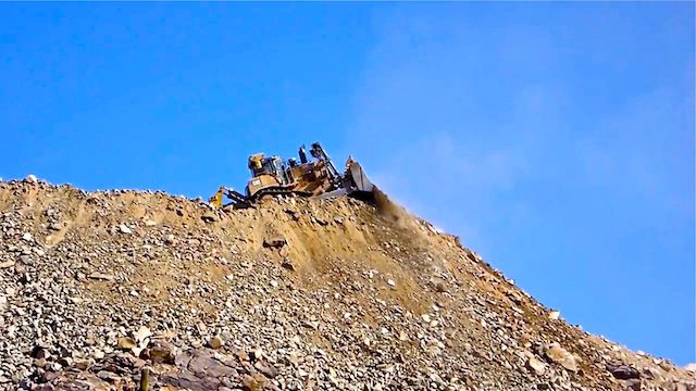
The access road up the north slope of Main Ridge South has replaced the rugged jeep trail that used to be there, so I had to bushwhack up to waypoint #7. It didn’t take long. There was a seismograph at the foot of the power tower. The seismograph was marked “Do Not Disturb”. My guess is the seismographs are for measuring possible structural stress on the power towers.
But I saw no signs of blasting. At least not yet. Lots of earth moving, though, being done by graders, dozers and a large hydraulic jackhammer. It looked like the grader was setting up piles for the dozer to push over the ridge’s crest, sending boulders bounding down hill. 🚜
Because I could not follow the old jeep trail across Main Ridge South, from waypoint #7 (on the ridge’s north spur) to waypoint #6 (on it’s south spur), I had to bushwhack down & up the steep wash separating the two. Like I did on my first survey hike, before I discovered the jeep trail. It took some care to pick my way over the jagged granite without gigging myself on the barbwire fence marking the Gila River Indian Community. At least I did not have to dodge any bees like I did in 2015. Better yet, there were no rattlesnakes. 🐍
I took a break sitting on one of the cement pilings for the power tower near waypoint #5. The power tower had another seismograph near it’s base. I had a bit of shade from the tower’s leg, which also made a handy backrest. I rehydrated — San Tan Brewing HopShock IPA — while watching the grader & dozer do their thing. (I’m not a big fan of IPAs — they’re too bitter for me — but the HopShock was pretty decent.)
From there, I simply backtracked to my SUV on Dusty Lane, and was home by noon.
So, progress is being made on the Loop 202 South Mountain Freeway’s Center Segment. Hopefully, when I do my next hike in early November, there will be some concrete sections in place. The freeway is due to open in late 2019.
Postscript: The Google satellite looks like it passed over about 18 months ago, as Google Maps satelllite view (erroneously) shows most of the buildings still standing in the Dusty Lane right-of-way, even though in Fall, 2016, they were already abandoned & condemned. (The homes were there, on the ground, when I did my fourth survey hike, on 10/28/2016, but missing when I did my fifth survey hike, a year ago.) But Google Maps has already indexed Hiddenview Dr. and Shaughnessey Rd. in The Promontory at Foothills West Summit Collection Community.
GPS File: Loop_202_South_Mountain_Freeway
Distance: 6.08 mi.
AEG: 1,061 ft.
Time: 2h 40m
Hike Video
Loop 202 Survey Hike #7 (4/20/18) from Preston McMurry on Vimeo.
ADOT not building sound wall in Dusty Lane.
I hiked new new road to Main Ridge North to the base of power tower at waypoint #16 which looks quite different today.
Main Ridge South also looks quite different as they have been busy taking it down too.
My guess is both ridges will be cut to nearly ground level–what have you heard/read?
There’s a fly-by animation video that was put out about four years ago that shows what they planned to do regards the two ridges, the approaches to them, and the valley in between. I know some plans have changed, like the Sandy Lane interchange, but I *think* the general plan is still in place. I was one of *many* people to upload a copy of the video to YouTube: https://www.youtube.com/watch?v=8vFJctzDAac . The center segment is discussed beginning at 2:38. It appears to be a combination of cutting & lifting, to allow for pedestrian access under the freeway. Thanx for visiting!
Progress is being made nearly daily with the 202 extension in/around Foothills West. 1st homeowner moved into the new development and is scheduled to have a pool dug even though blasting is occurring nearby. They have blasted parts of both ridges around the development and today I hiked the ridge overlooking the San Juan Rd/Trailhead on my way over to hike Alta.
I’ve heard some of the 125 new homes will be $725k and some of the distant lots have $100,000 lot premiums.
Email me if you’d like me to share any of my pics.
Interesting developments. I’ll drop you a line.
Drone flight conducted the day after my hike. The white spots on the ridge tops are, apparently, blasting holes. That would explain the seismographs I found.
Interesting to watch the progress. It would be insane to buy a $600,000 house so far out with the houses crammed right next to each other and no yard. Nuts!
Yeah, I sure would not spend that much to be so close to a freeway.
Sadly, all of your perceptions and comments regarding Promontory Foothills West are wrong. My yard is larger than most homes in the area. AS for the 202, the highway is being designed below the elevation of the Foothills area. So basically no sight or noise of a highway. Beautiful area surrounded by mountain views. Its a shame you can’t afford to purchase a beautiful $600,000-$700,000 home. All of your inaccurate comments make you sound like fools. Don’t hate just keep working hard…lol. Maybe one day you can step up your game and buy a nice home as well. Take care!
A water engineer told me: “Any perennial stream like a wash is considered a water of the US by the USGS since it flows during a big enough of a rain event. Discharging effluent from a WWTP would require an NPDES permit from EPA.”