

On Wednesday, the Coconino National Forest area closures & Stage III restrictions that went in to effect after I hiked Arizona Trail Segment #29 to Mormon Lake were rescinded. I immediately made plans to hike a canyon on the previously closed Mogollon Rim.
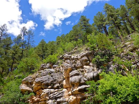
McCarty Draw is located between Miller Canyon and East Clear Creek. A ‘draw’ is a canyon which is shorter and less deep. That does not necessarily mean it is less rugged, tangled with undergrowth, deadfall and/or boulders.
I chose McCarty Draw because it is along Coconino National Forest FR 141. (FR being an abbreviation of ‘forest road’.) I’ve been wanting to drive FR 141, and turn it into a driving video for quite some time. 📽
McCarty Draw would be at least the 8th canyon I’ve bushwhacked in my quest to hike all the canyons along the Mogollon Rim. General Springs Canyon and Fred Haught Canyon were the last two, back in May.
After almost being run off the road by a psycho on I-17, just north of Cordes Lakes, we drove east on AZ-260 to the Mogollon Rim. Psychos excepted, it’s a quicker drive to the Rim than AZ-87 through Payson.
Rim Rd. / FR 300 was it’s usual washboarded & potholed self as we drove east along the Mogollon Rim. FR 141 was a great surface from Rim. Rd. almost all the way to Jones Crossing at East Clear Creek. (Between East Clear Creek and AZ-87, FR 141 was as bumpy & potholed as Rim Rd.) Before we reached Jones Crossing, we turned east onto FR 141E, which was also a very nice surface. We parked at the first clearing we found.
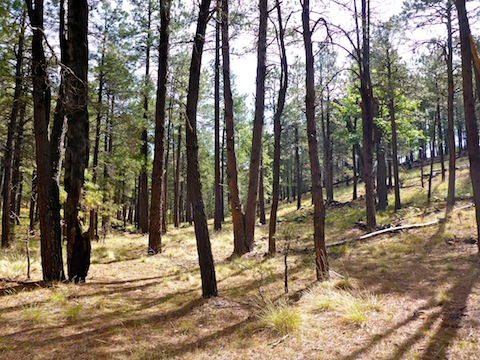
From the trailhead, I simply followed the low line north. The low line was mellow hiking, with no deadfall, rocks, tripper vines or even water. Occasionally, I would walk on the shelf.
I quickly found an elk spine, with many of the ribs still attached. I figured it had to be elk due to all the elk crap I found in McCarty Draw. Literally more elk crap than I’ve seen anywhere else. 🦌💩
Other than elk crap, McCarty Draw was mostly covered with pine needles. There are very few ferns.
In .80 miles, there is an ungated barbwire fence. It is easy to cross as it is collapsed where it crosses the bottom line of McCarty Draw.
There were a number of small side draws heading up McCarty Ridge, on McCarty Draw’s north slope. I figured “more of the same”, so didn’t explore them.
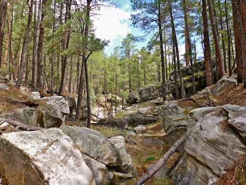
It wasn’t until halfway down McCarty Draw, 1.5 miles in, that it began tightening up a bit with rock outcroppings and deadfall (which was still easily avoided).
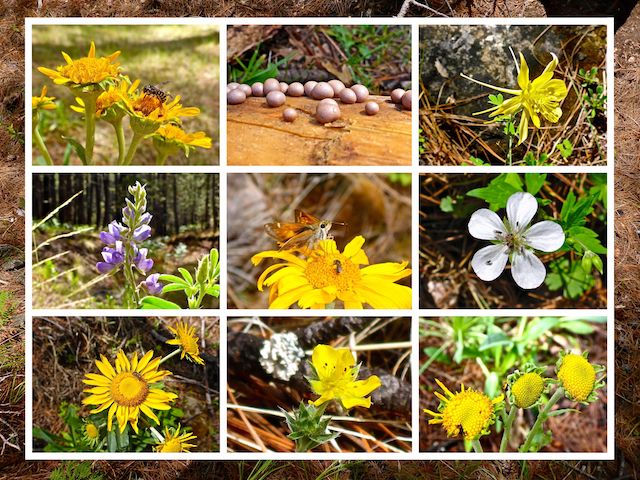
So the main attraction of the hike was flowers. The quantity was very low, but there the variety was good, maybe a dozen species. Lots of insects feasting at the flower drive-in, including several species of butterfly. Suprisingly, none of the butterflies flew off when I approached: All of them were very patient, some waiting over a minute while I took multiple photos. 🦋
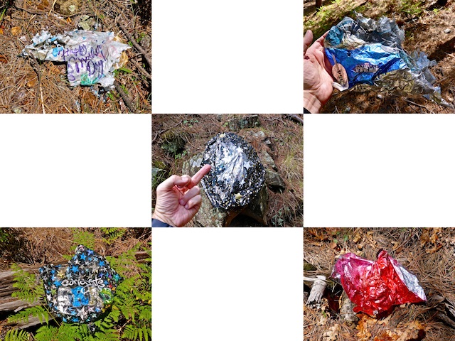
I found my first, but by far not only, mylar balloon where McCarty Draw beguns tightening up. It was a big one that barely fit in my hiking pant’s cargo pocket. (It was too wet from all the recent rain to put in my pack, where it would have doubtless grown new life forms.)
Two miles down McCarty Draw, I began finding some puddles, but no flow and nothing that rose to the exalted level of a small pool.
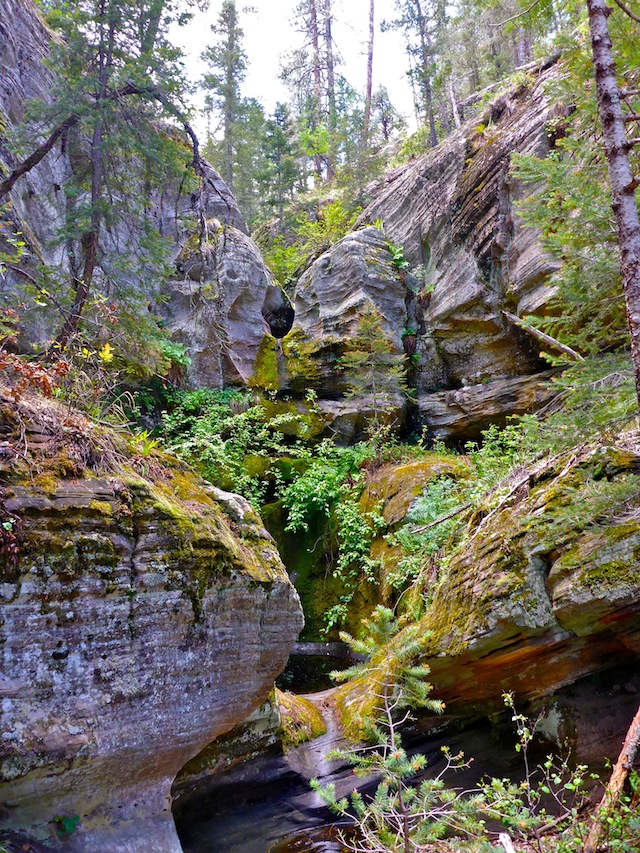
About a quarter mile south of Miller Canyon, 2.75 miles down McCarty Draw, my way was blocked by a small dryfall. I easily skirted it. It would have been pretty if water was flowing, but there was much better to come.
I took a break at the intersection of McCarty Draw and Miller Canyon. That’s where I made the acquaintance of the butterfly in this blog’s title image. 😁
If for some reason you need to bail, head south straight up the ridge to FR 141E which, as you may recall, is the forest road you parked on a few miles back.
Even though it is only a mile or two south of East Clear Creek and C.C. Cragin Reservoir, Miller Canyon was bone dry. It is a wide, moderately firm, gravel bed in both directions.
Instead, I hiked ‘up’ Miller Canyon, which rises a heart-pounding 30 ft. in one mile. There I found two small side canyons, right next to each other, on Miller’s south slope. Take the second one.
Just a few yards up that side canyon is the large dryfall. It would be amazing if water was flowing. Even dry, except for some small pools on its face, it was still very pretty. It would be a challenge for a young, fit, person to climb. 💪
I followed an elk trail 80 ft. up the bluff, then side-sloped until the side canyon rose to meet me. From there, I simply beat my way up canyon through endless ferns, and the deadfall and tripper vines they hid, to FR 141E. It would have been easier to simply turn left or right, and head 100 ft. upslope to a forest road, but I was determined to stay in the bottom line.
I found one, possibly two, more elk skeletons in the unnamed side canyon, plus four more mylar balloons. Seriously, screw your grandma’s birthday.
Directions: From Phoenix, head north on AZ-87, the Beeline Highway, through Payson, Pine and Strawberry. (Alternately, take I-17 north, then AZ-260 east.) 2.6 miles north of AZ-260, turn right onto Rim Rd. / FR 300. Rim Rd. is dirt and, at its western end, twisty and very bumpy. I would not do it in a car. In 7.4 miles, make a sharp left onto FR 141. After 5.8 miles on FR 141, turn right onto FR 141E. In a .25 miles, park on the left. When leaving, you can either head back the way you came, or continue north, then west, on FR 141 for 6.4 miles to AZ-87 in Long Valley.
GPS File: McCarty_Draw
Distance: 7.64 mi.
AEG: 496 ft.
Time: 2h 58m
Driving Video
Hiking Video
Hiking McCarty Draw, Mogollon Rim from Preston McMurry on Vimeo.