

Counter-clockwise from Bronco Trailhead, this is the 15th segment of the Maricopa Trail.
At the beginning of 2021, I set out to day hike the Maricopa Trail. (For the most part, it’s not remote enough for thru-hike camping.) I’ve also biked some of the long stretches of canal and suburban sidewalk, which go by much quicker on two wheels. I am doing the loop counter-clockwise. 🔄
Though not official, I’ve divided the Maricopa Trail’s 245 miles into 25 segments, such that each is anchored on some sort of trailhead, which is important if you want to avoid being ticketed, or you want your shuttle driver to be able to pick you up at the end of your excursion.
For Maricopa Trail completists without a shuttle driver, Telegraph Pass to Pima Canyon out-and-back would be a very long day at 15½ miles, 2,400 ft. AEG (accumulated elevation gain). In that situation, I would instead divide this segment up, turning around at Buena Vista Trailhead: Roundtrip from Telegraph Pass is 5¾ miles, 1,000 AEG; roundtrip from Pima Canyon Trailhead is 9¾ miles, 1,400 AEG.
I’ve hiked all of the 15th Maricopa Trail segment, but never in one go: My second ever HikeArizona triplog (2010) was for the middle segment, from Buena Vista Lookout to Fat Man’s Pass. In 2019, I hiked the third segment from Fat Man’s Pass to Pima Canyon Trailhead, after looping out along Guadalupe Ridge. And in 2020, I hiked the first segment from Telegraph Pass to Buena Vista Lookout, while looping Corona de Loma Trail. 🗺
Unlike Thanksgiving 2010, it was cold on Wednesday, with winds 12-15 mph, gusting up to 20 mph. Instead, I waited until Thursday, when it was slightly “warmer”, with winds much less. After what I went through in January, I didn’t need to get sick again.
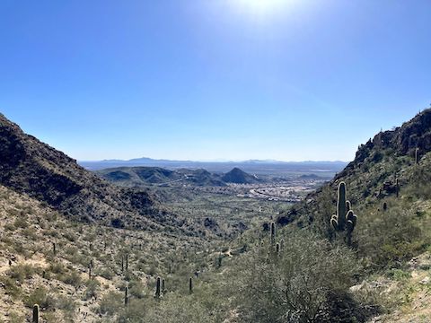
From Telegraph Pass, hike northeast on the Maricopa Trail, which parallels Telegraph Pass Rd. for ¾ mile, before turning east, away from the road, along the north slope of Mount Suppoa. The trail climbs 450 ft. in 1½ miles to a saddle just east of the Mount Suppoa antenna farm. A “summit log” is contained in the mailbox which marks the National Trail’s high point.
I mention the National Trail as it is colocated with the Maricopa Trail for 14 of its 15 miles. Compared to previous segments, there were relatively few Maricopa Trail signs. The singletrack is obvious, but when in doubt, look for metal posts with a white “N” on purple sticker. The sticker has latitude / longitude, elevation profile, directional arrow and QR code. (Distance is often missing.) 🤔
A ½ mile after the summit log, Maricopa Trail crosses TV Road, which splits off Buena Vista Rd. to access the Mount Suppoa antenna farm and Gila Valley Lookout. In another ⅔ mile, Maricopa Trail intersects Corona de Loma Trail 100 yds. from Buena Vista Lookout. To the right, and 50 ft. above Buena Vista Rd., is an old helipad with a good view of Chinese Wall.
Two loud rice burners drove up—the first dangerously over the yellow line—as I approached Buena Vista Lookout. Thankfully, they did a U-turn and left. Maricopa Trail continues just the other side of the parking lot. As the trail dips towards a saddle, it is spotted with dog crap and graffiti. I have no problem with tagging ugly, out of the way, places like underpasses, but besmirching nature is a dick move. 😡
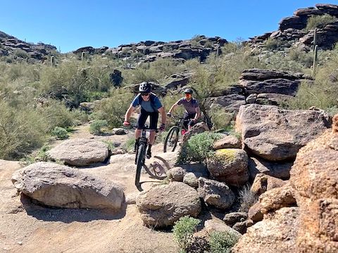
From that saddle, Maricopa Trail makes a short, steep, climb to another saddle, and is essentially downhill the final 4½ miles to Pima Canyon Trailhead. I only saw three mountain bikes west of Buena Vista Lookout, but east of it MTBs were quite frequent, most of them making the rugged climb west towards Buena Vista Lookout. (I saw one guy walking his MTB up the “crazy hard” Waterfall).
I probably should have stayed at the Waterfall, but instead I took a sit down break at a bend just before Fat Man’s Pass. Of course, no mountain bikes rode by for twenty-eight minutes. Damn, that granite made my ass sore!
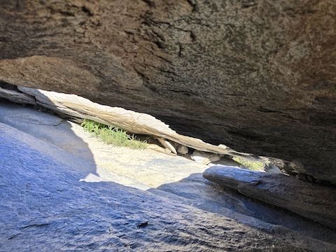
Fat Man’s Pass is visible just off the Maricopa Trail, 4½ miles into this hike, and 1⅔ miles east of Buena Vista Lookout. I squeezed through in 2010, but not 2019, so I approached Fat Man’s Pass with some concern. I had to take off my Camelbak, and empty my shirt pockets, but I made it through. Twice. (The second time on video.) Rather than continue on trail, I continued down wash towards Hidden Valley.
The Hidden Valley diversion is essentially the same distance as the Maricopa Trail, with less foot traffic, and no MTBs. Unlike 2020, there was no crowd at the slick rock crevice, so I was able to slide through. (Webber Mine was a tighter fit.) Hidden Valley is a 3 ft. wide, 5 ft. high, chock stone “tunnel” located just before the wash reconnects to the Maricopa Trail. Don’t skip Hidden Valley! 📸
Once reconnected to the Maricopa Trail, it is 2½ miles to Pima Canyon Trailhead. There’s a nice view west, before Maricopa Trail switchbacks down 300 ft. in ½ mile to the canyon bottom. Just before the trail turns to dirt road at the stone cabin, three French gals stopped on their MTBs. Despite not parlez-vous, I understood their question, pointing them up National Trail.
Telegraph Pass Directions: From Phoenix, head south on Central Ave. until it enters South Mountain Park. Mind your speed, as there is a lot of bicycle traffic on the narrow road, and hikers crossing it. In 2½ miles, curl up to the left on Telegraph Pass Rd. It is 1¾ more twisty miles to Telegraph Pass. There is a paved pullout with room for about four vehicles on the left / downhill / opposite side of the road.
Pima Canyon Directions: From Phoenix, head south on I-10. Take exit 157 west onto Elliot Rd. Stay right. Turn right onto 48th St. In 1 mile, turn left to stay on 48th St. Take the very next left onto Pima Canyon Rd. The Pima Canyon Trailhead is at the end of the road in ½ mile. Parking is free.
Park Map: South_Mountain_Park_Trail_Map (pdf)
GPS File: Maricopa_Trail_Telegraph_Pass_to_Pima_Canyon_Trailhead
Distance: 8.30 mi.
AEG: 829 ft.
Time: 2h 58m
Hiking Video
Maricopa Trail: Telegraph Pass to Pima Canyon from Preston McMurry on Vimeo.