

The second of my two Easter weekend hikes on the C&O Canal. It was supposed to be the first one, but I called an audible and hiked from Snyder’s Landing to McMahon’s Mill (MP 88.1) on Friday instead. The C&O Canal Towpath is 184.5 miles long, from Georgetown, DC, to Cumberland, MD. After today, I will be almost halfway done.
Thankfully, this morning was 15° warmer, so I was able to hike to the Weverton Cliffs without any extra layers. Don’t get me wrong: I thought about wearing my hoodie, but it was expected to warm up quicker, and to a higher temperature, than on Friday. In the meantime, I could overcome mid-morning coolness by generating body heat.
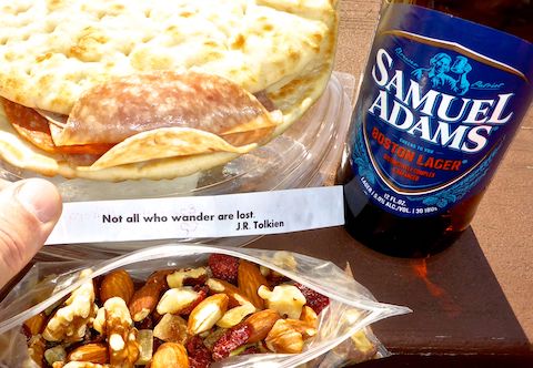
MP 44.6: Nolands Ferry has a tiny paved parking lot, boat ramp, picnic area, doggie doo bag dispenser and pit toilet. Per my usual on “away hikes”, I carried no hiking gear, just a 20 oz. bottle of water and a snack — which in this case was gorp made by my mom, and included a note, just like she used to pack lunch when I was in grade school. 🤗

A few hundred yards from Noland’s Ferry is a old stone building that I first thought was a church. It had no history signs. Looking at sat view, I think it is a water intake for the Frederick County water treatment plant a half mile north.
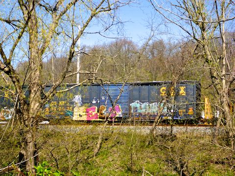
There were some rather large trees along the Noland’s Ferry to Weverton Cliffs segment of the towpath: One had a “cave” in it that two hikers and their gear could have sheltered from the rain in! Coincidentally, that tree is also about where the train tracks and C&O Canal basically merge. (The towpath on the Potomac River side of the canal; the tracks on the other side of the canal.) Between CSX, the MARC commuter line, and Amtrak, 35-40 trains pass by each day, but I only saw maybe four in five hours. The tracks continue to follow the C&O Canal until they split off into Harpers Ferry. 🚂
MP 47.6: Calico Rocks Campground a portapotty, picnic table, grill, direction & distance sign and doggie doo bag dispenser. Good thing I did not need water, as the well hand pump had no handle. I wonder if the handle broke, was stolen, or if it was removed because maybe the well freezes in winter? I suppose, if necessary, you could filter from nearby Kanawha Spring.

Top Row: arrow-leaved violet, spring beauty, lesser celandine.
Middle Row: common grape hyacinth, wild daffodil, Virginia bluebell.
Bottom Row: cutleaf toothwort, speedwell (not sure which subspecies), Dutchman’s breeches.
MP 48.2: Point of Rocks Boat Ramp has a large parking lot, two pit toilets, a picnic table, doggie doo bag dispenser and … a boat ramp. Of course. When I first planned this hike several years ago, today’s segment was shorter, and included a short diversion up to the Point of Rocks Overlook, which has good views of the US-15 bridge, and passing trains. With many more miles ahead, I forged on. 🛶
MP 49.0: Lockhouse 28 (c. 1837) is part of the C&O Canal “Canal Quarters” program, where you can rent a historical lockhouse for a couple of nights. The lock is referred to as Fulton’s Lock 28, or Dent’s Lock 28. There is no water, plumbing or electricity, but Lockhouse 28 has a picnic table, stools, firepit, crib of firewood and a spacious handicapped-size portapotty. Parking is at Point of Rocks. The nearest water is at Bald Eagle Island Campground …
MP 50.3: … except the well hand pump at Bald Eagle Island Campground was also missing its handle. Gotta be some seasonal park service shenanigans. What the campground does have is a picnic table, grill, firepit, direction & distance sign, doggie doo bag dispenser that was empty and a portapotty that was full. (Though not to the level of Easterville, in northern Manitoba: There was no pit below the seat, so when crap piled up to ass level, they picked up the outhouse and moved it over a few feet. No lie.)
MP 50.8: Not quite halfway between Noland’s Ferry and Weverton Cliffs, Lander Lock 29 is where I met my wife for lunch, a fresh bottle of water, and a change of socks. (It is sometimes referred to as Catoctin Lock 29.) Lander Lock 29 has a bike rack — of all things! — picnic table, pit toilet and boat ramp.
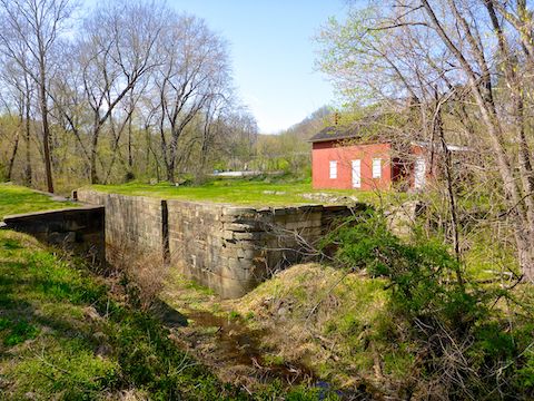
MP 51.5: When hiking the C&O Canal Towpath, I normally don’t spend much time reading the many history signs. Though not as spectacular as the Monocacy Aqueduct (MP 42.2), I made an exception for the Catoctin Aqueduct, reading about the restoration effort. Just yards away, the railroad passes over an equally interesting stone bridge, but unfortunately I could not get a decent photo of them both together. 😕
MP 52.4: The C&O Canal Towpath detours around the next stone bridge, which is itself collapsed. This is about where the Brunswick Railyard begins. The “seven mile long” railyard was apparently the largest owned by a single company (the B&O Railroad).
MP 54.0: The Brunswick Family Campground is located just east of the sewage treatment plant. There’s cabins, showers, a jungle gym, room for dozens of RVs and dozens of tents, and jillions of outhouses and picnic tables. It’s really something. I thought about stopping for ice cream, or a cold soda, but wasn’t sure where the store is. For that ¾ of a mile, the trail is down the middle of “Canal Towpath Road”.
MP 55.0: The Brunswick Boat Ramp and Lock 30 are just west of where “Canal Towpath Road” turns into town, allowing the trail to once again be actual trail. Besides the boat ramp, there are multiple picnic tables and grills, a decent size parking lot and a pit toilet. (There’s a massive commuter parking lot on the other side of the train tracks.) I took a final break, finishing my sandwich. 🥪
MP 57.1: I only noticed there is an old hobo camp here because there was a tiny icon on whatever GPS map set it is I have loaded on my crappy Garmin 62S. I tried balance beaming across the watery canal bed, but ended up getting muddy. All that’s left of the hobo camp is random bits of rusty equipment.
MP 58.0: There were a lot of people walking and biking between Brunswick and Weverton Lock 31, which is halfway from Brunswick to Harpers Ferry. Considering how far I walked, I felt pretty good. After drinking my traditional post hike V-8 (for sodium and potassium replacement), I changed into loafers, and my wife & I were off to our hotel in Hagerstown, to get a good night’s sleep before flying home to Phoenix the next day. ✈️
Noland’s Ferry Directions: From I-270, take exit 31 south onto MD-85 towards Buckeystown. Where MD-85 begins bending left, at the intersection with MD-28, turn right. In a mile, turn left on New Design Rd., which ends at Nolands Ferry in ¾ of a mile.
Weverton Lock 31 Directions: From I-270, take exit 29 south onto MD-66 / Mapleville Rd. In 5.3 miles, turn left onto Old National Pike. In 1.2 miles, at the traffic circle, take the first exit onto MD-67 / Rohrersville Rd. In 12.6 miles, curl east onto US-340. In 0.3 miles, take the first right onto Keep Tryst Rd. Park alongside the road in 0.2 miles.
GPS File: CO_Canal_MP44to58_Nolands_Ferry_to_Weverton_Cliffs
Distance: 15.49 mi.
AEG: 351 ft.
Time: 4h 43m
Hiking Video
C&O Canal: Noland’s Ferry to Lock 31 from Preston McMurry on Vimeo.