

I had originally planned to hike the Chesapeake & Ohio Canal Towpath eleven miles from Edward’s Ferry to Monocacy Aqueduct for my first Easter hike, and then nine miles from Monocacy Aqueduct to Lander Lock 29 for my second Easter hike, but the coronavirus panic scotched those plans.
I really want to be able to complete the C&O Canal’s 184 miles with two day hikes, twice a year, so to get back on schedule I planned two 14-mile hikes for our Halloween visit: First Edward’s Ferry (MP 30.9) to Noland’s Ferry (MP 44.6) on Friday, then Noland’s Ferry to Lock 31 (MP 58.0) at Weverton Cliffs on Monday. 💪
Since the C&O Canal is basically flat as a board, and the towpath is smooth & obstacle free, that effort was within the gift of a 58-year old fat man’s abilities.
This year, rather than flying, I drove from Phoenix to Maryland. Having passed through the hills of southern Ohio, West Virginia and western Maryland, the fall color was well past peak. Basically browns, with only scattering of rotten banana yellow leaves. So, I was not expecting much from hiking the C&O Canal, other than the usual array of interesting engineering and Civil War markers. (Primarily from the Antietam Campaign.)
MP 31.0: Edward’s Ferry has a medium-sized paved parking lot, boat ramp, picnic area and pit toilet. There is a portapotty next to Lockhouse 25, as it has no plumbing, water or electricity. We saw some folks walking in the door, so we followed them, figuring it was a tour. Nope! They were staying overnight as part of the Canal Quarters program. That was embarassing … 😊
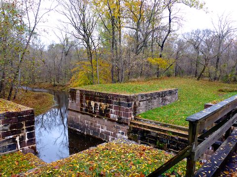
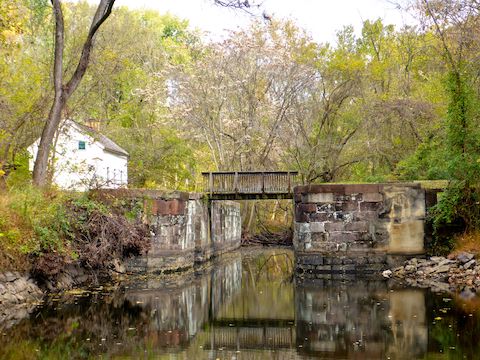
MP 31.9: There is some controversy over whether the C&O Canal structure at Broad Run was a culvert or aqueduct. There are tons of culverts along the towpath, but none I have so far seen have the heavy stone structure that is at Broad Run. On the other hand, if Broad Run was an aqueduct, it’s awful small compared to Seneca Creek Aqueduct or Monocacy Aqueduct.
MP 34.5: Turtle Run Campground, across the Potomac River from Harrison Island, has free camping. There is a well hand pump, picnic table, firepit, direction & distance sign, doggie doo bag dispenser and — for humans — a portapotty. The nearest parking is at Whites Ferry.
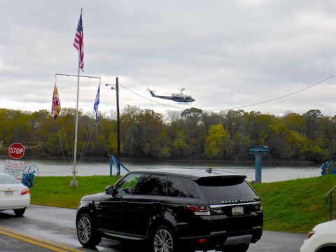
MP 35.7: Whites Ferry — founded in 1782 while the American colonies were still technically revolting against King George III — is the only Potomac River chain ferry still in operation. (At it’s peak, the Potomac River had 100 ferries.) The ferry makes a round trip every 20 minutes. Cost per car is $5 one way to Leesburg, VA; $8 round trip. While I was watching the ferry, it was buzzed by two government helicopters flying fast & low. (Like 100 ft. … at most.) I wonder what that was all about? 🚁
It was cold enough, I bought a hot coffee in the bait shop. (There is a restaurant open in warmer months.) A privately run facility, White’s Ferry has canoes, picnic tables, grills and even a outdoor pavilion for rent. It has a large gravel parking lot. The bathroom building was locked, but there is also a portapotty.

MP 38.2: Marble Quarry Campground … The nearest parking is at Dickerson Trailhead. Camping is free. There is a well hand pump, picnic table, grill, firepit, direction & distance sign, doggie doo bag dispenser and portapotty.
MP 39.4: Wood’s Lock 26 had a lockhouse, but all that’s left is the foundation. I assume all locks had a lockhouse at some point, but many I’ve spotted on my C&O Canal hikes have not. The cool part, though, was that perched on the edge of the lock, right in front of a spooky old tree, somone had left three jack-o’-lanterns. 🎃
MP 39.7: Rather than refilling my water bottle from an iodine-treated campground well pump, I met my wife at the Dickerson Conservation Park trailhead for a fresh bottle. There was a good size gravel parking lot and several garbage cans. (The campgrounds are all pack it in, pack it out.) My left foot was getting tingly, but with only a ⅓ of my hike remaining to Nolands Ferry, I pressed on.
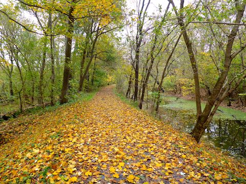
Where the trees were mostly empty of leaves early on, the fall color got steadily better — though never great — the further I hiked.
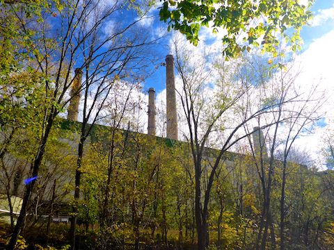
MP 40.6: The massive 853MW Dickerson Generating Station is powered by coal, gas & oil. The plant borrows up to 400 million gallons of water out of the Potomac River every day, to cool steam pipes. The warmed water is returned to the river via a 900 ft. long concrete discharge channel lined with boulders. The discharge channel doubles as an Olympic-level kayak course. I was not expecting to see any kayakers training, but was hoping to at least take a look at the course. No such luck: It was gated & locked. 😕
MP 41.5: Nothing really special about Spinks Lock 27, but the locked lockhouse — haha! — has been restored. The nearest parking is at Monocacy Aqueduct. I was starting to suspect my left foot tingle was more than just a hot spot: It was getting painful to walk on.
MP 42.2: The Monocacy Aqueduct — whose seven arches span 516 ft. — is one of the highlights of the C&O Canal. Each aqueduct was made of whatever stone could be locally quarried, white & pink quartz sandstone in Monocacy’s case. (Seneca Creek Aqueduct at milepost 22.8 is made of red sandstone.) There is a mdium-sized gravel parking lot, rest benches, picnic tables, pit toilet, boat ramp and the usual array of historical signs. Of particular note, Monocacy Aqueduct is so massive, Confederate general D.H. Hill was unable to blow it up during the Civil War. 🧨
Indian Flats Campground, just past the north end of Monocacy Aqueduct, has a well hand pump, picnic table, firepit, direction & distance sign, doggie doo bag dispenser and portapotty. Camping is free.
MP 44.6: Nolands Ferry has a tiny paved parking lot, boat ramp, picnic area, doggie doo bag dispenser and pit toilet. My ever faithful shuttle driver, aka wife, was at Nolands Ferry waiting for me. I had left loafers and regular socks in my SUV. When I took my left hiking shoe off, I discovered a massive blood blister under my big toe callus. Yikes! Even after two days of resting, I did not think it was wise to push the matter and do my second planned 14-miler to Lock 31 on Monday. Relucantly, I cancelled. Not sure what I’ll do now about completing my C&O Canal “thru” hike …
Edward’s Ferry Directions: From I-270, take exit 109 onto MD-109 / Old Hundred Rd. In 5.3 miles, in Barnsville, take a quick right-left to stay on MD-109. In another 6.0 miles on MD-109, in Poolesville, make a quick right-left onto Willard Rd. In 0.6 miles, slant right onto Westerly Rd. In 1.5 miles, turn left onto Edward’s Ferry Rd. To avoid I-270, which carries a lot of D.C. traffic, take MD-85 and MD-28 to Beallsville, before turning south on MD-109.
Noland’s Ferry Directions: From I-270, take exit 31 south onto MD-85 towards Buckeystown. Where MD-85 begins bending left, at the intersection with MD-28, turn right. In a mile, turn left on New Design Rd., which ends at Nolands Ferry in ¾ of a mile.
GPS File: CO_Canal_MP31to44_Edwards_Ferry_to_Nolands_Ferry
Distance: 15.23 mi.
AEG: 208 ft.
Time: 4h 40m
Hiking Video
Hiking C&O Canal: Edwards Ferry to Nolands Ferry from Preston McMurry on Vimeo.