

My wife and I were in Houston the end of February, so I didn’t get a hike in the week we left, as we were gone my “work” days. (Friday, Saturday and Sunday, when I edit photos, edit the GPS route, write my blog and produce the hiking video.)
I was worried I had missed out on the best #flowerporn, but luckily that turned out not to be the case!
I had seen several reports, from different locations in the Phoenix Sonoran Preserve, that the park had particularly good coverage, especially along trails in the unit north of Sonoran Desert Drive, such as Sidewinder Trail, Apache Vista Trail, Apache Wash Trail, Ocotillo Trail, Ridgeback Trail and Ridgeback Overlook Trail. Also mentioned was the Dixie Mountain Loop in the south unit.
I decided to hike the Phoenix Sonoran Preserve’s south unit, but (mostly) avoid Dixie Mountain Loop, as I did not want to “steal the thunder” of a twitter follower who had posted some very nice flower photos from that trail. 😇
Though I hadn’t made a full hike video of the Dixie Mountain Loop, I had already hiked it three times. Starting from Desert Vista Trailhead, I would head up Hawk’s Nest Trail, then counterclockwise on Dixie Mountain Loop for a ½ mile, southeast on Valle Verde Trail for a mile, continue southeast on Cactus Wren Trail for 1½ miles, turn west on Great Horned Owl Trail for a ½ mile, divert a ½ mile up to the summit of Union Peak (then back down), continue another ½ mile west on Great Horned Owl Trail, back northwest on Valle Verde Trail for a ½ mile, west on Desert Tortoise Trail for a hair over a mile to Hawk’s Nest Trail, and finally back to Desert Vista Trailhead. 🤔
Sounds complicated, I’m sure, but drawn out it looks like a retarded figure-8. If you want to follow my route, there is a GPS file attached below. Or you could just wing it: With all the signage in Phoenix’s city parks, you have to try to get lost. (That said, the day before a rescue chopper was airlifting some doofus off North Mountain, across from my office window.)

Hawk’s Nest Trail is rated moderate. I’d say that is a fair assessment as the trail climbs 230 ft. in 0.4 miles. (Or the equivalent of 600 ft. in a mile.) It’s not long, but it is enough to warm up your leg muscles. Hawk’s Nest Trail is wide and in great shape. (As were all the other trails I hiked in the Phoenix Sonoran Preserve.) Brittlebush predominated — as they have for the past month throughout Phoenix — but there were also some lupine along the trail.
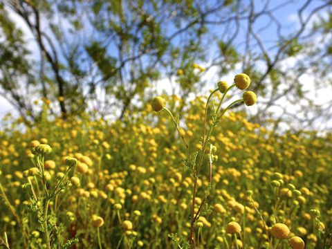
Dixie Mountain Loop is rated moderate, but that is for the whole trail (not including Dixie Mountain or Western Vista summit.) The ½ mile between Hawk’s Nest Trail and Valle Verde Trail is easy, the slight climb barely noticeable. The flowers along this short section of Dixie Mountain Loop included desert chicory, blue dick, lupine and brittlebush. 🌼
While Hawk’s Nest Trail and Dixie Mountain Loop existed when I first hiked the Phoenix Sonoran Preserve, the next five trails were either under construction or in the planning stages.
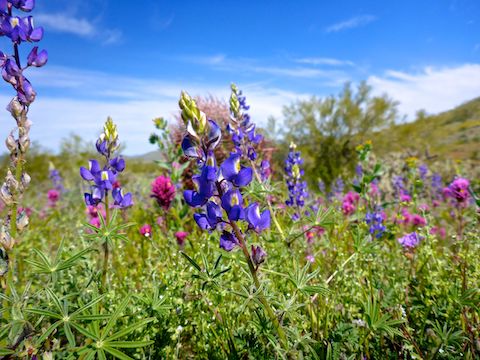
Valle Verde Trail is rated moderate. Heading southeast, the trail drops 170 ft. in the first ½ mile and is basically flat thereafter. So, I assume the rating is for hikers headed the opposite direction, northwest. At the junction with Dixie Mountain Loop, Valle Verde Trail has some nice views of the Cave Buttes Recreation Area, the greenery along Apache Wash, and further into mountains around Cave Creek. (Elephant Mountain and Sugarloaf Mountain stood out.) The flowers along Valle Verde Trail included lupine, globe chamomile, blue dick, fiddleneck, owl clover, scorpionweed and lots of Mexican gold poppy.
Cactus Wren Trail is also rated moderate, but other than a few wash crossings was also flat. It should be rated easy. I continued to find Mexican gold poppy and scorpionweed, while the owl clover and lupine density increased. I took some really nice photos with multiple flower species mixed tightly together. 📸
Cactus Wren Trail is where I had my first rattlesnake encounter of the spring: A small, maybe 30″, western diamondback with indistinct diamonds. A retired couple, completely unaware, were resting in the shade a few yards away. That’s the thing about rattlesnakes: They are all around you, all the time, you just never realize it because they don’t feel threatened enough to make you aware of their presence.
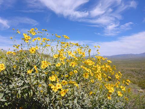
Great Horned Owl Trail is rated moderate because it climbs 200 ft. in a ½ mile to a saddle on the north slope of Union Peak. That is true whether you are hiking east or west. Unlike the earlier trails, Great Horned Owl Trail was single track, but still a good surface. As elsewhere throughout the Sonoran Desert Preserve, there is very little shade. I tried to make myself small under a palo verde while I swapped out water bottles. Flowers along Great Horned Owl Trail included creosote, globe chamomile, brittlebush, desert chicory and, of course, lupine and Mexican gold poppy. (The Mexican gold poppy were at their most glorious west of the saddle.)
Union Peak Trail is rated moderately difficult, a step up from moderate. It climbs 260 ft. in a ⅓ of a mile. (The equivalent of a steep 800 ft. in a mile.) Though the surface did not get bad, it did require more care with foot placement. I was tired enough I wasn’t sure I wanted to even try Union Peak Trail, but I made it. 👍
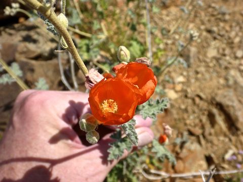
The trail continues 200 yds. past the actual summit of Union Peak to a observation point. South past Deer Valley Airport, I could clearly see Camelback Mountain, Piestewa Peak, North Mountain and Shaw Butte. The only summit flowers were the sole desert globemallow of the day.
After an extended break on Union Peak, including a hiking beer — Hofbräu Dunkel — I headed back down to the saddle, then west on Great Horned Owl Trail, where I found those large, dense patches of Mexican gold poppy.
Desert Tortoise Trail is rated moderate, but should be rated easy. It bypasses the short climb back up Valle Verde Trail, but saves no real distance back to the Desert Vista Trailhead. Despite being not at all difficult, I still took several 10-second breathers. (Besides the climb up Union Peak, I was under-watered for higher than expected temperatures.) I certainly was in no mood to take pictures or even much notice what kinds of flowers it had, other than the ubiquitous brittlebush.
It’s a bit difficult finding the Desert Vista Trailhead (directions below), and I had an even harder time finding my way back to streets I was familiar with, like Deer Valley Dr. It’s much easier navigating in the boondocks! 😁

Directions: Head north out of Phoenix on I-17 / Black Canyon Freeway. Take exit 219 east onto Jomax Rd. In a mile, turn left onto 19th Ave. / North Valley Pkwy. In a mile, turn right onto Copperhead Trail. Take the second left onto Melvern Trail. Just past the community center, turn right onto Desert Vista Trail, which ends at the Desert Vista Trailhead in ⅓ mile.
Park Map: Phoenix Sonoran Preserve Park Map (pdf)
GPS File: Phoenix_Sonoran_Preserve_Union_Peak
Distance: 7.59 mi.
AEG: 995 ft.
Time: 2h 59m
Hiking Video
Hiking Phoenix Sononoran Preserve from Preston McMurry on Vimeo.