

Counter-clockwise from Bronco Trailhead, this is the 21st segment of the Maricopa Trail.
My goal is to hike or bike all 245 miles of the Maricopa Trail, which encircles the Phoenix metro area, aka The Valley of the Sun. I am doing one segment roughly every month, from late fall to early spring, when temperatures are less than the surface of the Sun. I spend summer on the Mogollon Rim.
The previous 52 miles of the Maricopa Trail, from Pima Canyon to Taliesin West, were canals and sidewalks. So, today was the first time in many months I was able to put my feet on Maricopa Trail singletrack. But not straightaway.
The Taliesin West to Gateway Trailhead segment does not actually start at the Taliesin West parking lot, but at it’s entrance on Frank Lloyd Wright Blvd. Where there is no place to park. Personally, my wife dropped me off around the corner on residential Laurel Ln. Another spot would be the canal maintenance pullouts 150 yds. up Taliesin Dr. Either way, this is a shuttle hike.
Unless … you extend the 20th Maricopa Trail segment from Detroit Coney Grill three miles past Taliesin West to Quartz Trailhead, for a total of 10½ miles. If you do that, then you could do Quartz Trailhead to Gateway Trailhead as a 7½ mile out & back hike. But when I started this project, I didn’t know Gateway Trailhead existed, so here we are. 🤷🏻♂️
From the Taliesin West sculpture, the Maricopa Trail heads north as singletrack, closely paralleling Frank Lloyd Wright Blvd. To the right is a chainlink fence, berm and powerlines. At ⅓ mile, turn right across the Hayden-Rhodes Aqueduct, then immediately turn left, along the powerline road. And there are a lot of powerlines.
In 300 yds., the Maricopa Trail does another quick right right-left, climbing 20 ft. up the canal berm, then goes straight down the middle of the powerlines. Several holes of McDowell Mountain Golf Club are down in the wash. At 1¼ miles, the 2nd green, and Quartz Trail are on the right.
Just past the paved cart path four-way intersection, the Maricopa Trail does a quick left-right, down into the wash. If you look up, that small building by the 3rd tee is a restroom. It’s private property, but if you gotta go, you gotta go. The his & hers are single occupancy, clean, flush, running water, with hand cleanser. 🚻
At 1⅔ miles, to the right of the Maricopa Trail, is a cement spillway, studded with “dragon’s teeth” like it’s Omaha Beach. I wonder what the “dragon’s teeth” are for? Maybe to prevent boulders washing downstream?
At 2 miles, Maricopa Trail turns right, passing between McDowell Mountain Golf Club’s 12th and 15th greens. (This is the other end of Quartz Trail, per signs.) Another restroom building is there. Don’t stray onto any of the several cart paths: Stay on dirt. Again singletrack, the trail hugs a wall for 150 yds., then turns northeast, along the bank of a shallow wash.
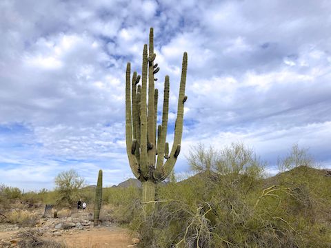
The Maricopa Trail remains in that small wash, lined by high-end homes, for the next two miles. I’d only seen one hiker earlier — ironically, the same one at both ends of Quartz Trail — but I saw occasional foot traffic between the McDowell Mountain Golf Club and Paradise Ln. No horses: The houses are too tightly packed for corrals. 🏘
At 2⅔ miles Maricopa Trail crosses a multi-use trail. In 350 yds. is a sign for Quartz Trailhead. At 3 miles, the trail passes under the 105th St. bridge. (Where I saw the only graffiti of the day: Scottsdale don’t play.) At 3⅔ miles, the trail splits left, off Quartz Trail, and 300 yds. later through the tunnel under Paradise Ln. Finally, at 4 miles, it becomes traditional desert hiking.
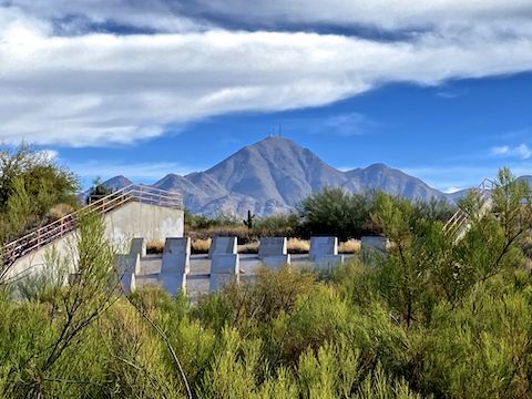
The Maricopa Trail — which has been imperceptibly climbing all along the wash — increases it’s angle, climbing 240 ft. in a mile to Gateway Loop Trail. Though never far from civilization, it is the most remote part of this segment. If you look back, there’s just enough elevation gain you can see most of the northeast Valley, including Scottsdale Airport, in whose flight path this segment lies.
I was going to stop for lunch at the Levee Trail intersection, but after unwrapping my chorizo breakfast burrito, decided instead to eat it on the fly. It was okay. I think my wife enjoyed it more on the drive home. 😇
Once Maricopa Trail joins Gateway Loop Trail at the 5-mile mark, it is all downhill to Gateway Trailhead. Tons of foot traffic too. I’ve now completed 199.72 miles of Maricopa Trail. Four more segments to go!
Taliesin West: There’s a spot on the northeast corner of Taliesin Dr. and Frank Lloyd Wright Blvd. where someone could drop you off real quick, or pull over to pick you up, but it’s not for parking. See above.
Gateway Trailhead: From Loop 101, take exit 36 onto Pima Rd. At the second light, turn right onto Legacy Blvd. In just over a mile, turn right onto Thompson Peak Pkwy. In a half mile, turn left into Gateway Trailhead.
GPS File: Maricopa_Trail_Taliesin_West_to_Gateway_TH
Distance: 7.28 mi.
AEG: 618 ft.
Time: 2h 18m
Rumble Video
Vimeo Video
Maricopa Trail: Taliesin West to Gateway Trailhead from Preston McMurry on Vimeo.