

Counter-clockwise from Bronco Trailhead, this is the 16th segment of the Maricopa Trail.
My goal is to hike or bike all 245 miles of the Maricopa Trail, which encircles the Phoenix metro area, aka The Valley of the Sun. Between 90-100 miles of the Maricopa Trail are canals or sidewalks, including all 13 miles east from South Mountain Park, though Guadalupe and Tempe, to Freestone District Park in Gilbert.
If you don’t have a shuttle driver, as I did, a round trip from either Pima Canyon Trailhead or Freestone Distric Park is 26½ miles, 260 ft. AEG (accumulated elevation gain). Other than a short roadside climb / descent in Pima Canyon, this Maricopa Trail segment is bone flat. If you aren’t up to riding 26 miles, or are walking it, Carriage Lane Park makes a good almost halfway turnaround. ↩️
When I bought my GoPro HERO10 Black early last year, I also bought two mounts: handlebar and helmet. The handlebar mount was easy to install, but I never did figure out the helmet mount — which had a confusing series of straps. (My helmet is vented, not solid like a karting helmet.)
The GoPro handlebar mount, though, only rotates vertically — not horizontally. So, I recently bought a GoPro Ball Joint Buckle mount, which allows the camera to simultaneously rotate through both the x- and y-axis. Coverage is nearly 1080°, except through the mount itself. (Which the GoPro’s wide angle mostly compensates for.) As an added bonus, the ball joint is actually stiffer, so less likely to be knocked out of alignment by even light jarring. 👍
So, besides my route, my other plan for today was to change the GoPro’s angle every mile or so, showing the beauty ahead of me, to my right, below me, to my left, and of my own smiling mug.
This segment of the Maricopa Trail starts by following the dirt path on the left (north) side of Pima Canyon Rd. At the unmanned park gate, make a right onto the sidewalk for 200 ft., then left onto the sidewalk on the north side of Pointe Parkway. After 300 yds., split right onto a dirt path, slightly up to the stoplight. Turn right onto the sidewalk on the north side of Guadalupe Rd., crossing Interstate 10.
From I-10, there’s a zippy little drop into the Yaqui hamlet of Guadalupe. After 1¼ total miles, at Avenida del Yaqui, the Maricopa Trail makes a quick right-left onto a crushed gravel path on the south side of Guadalupe Rd. After a rainy night, it was the firmest dirt path between South Mountain and Freestone Park. Just before the Highline Lateral Canal, the Maricopa Trail turns to concrete as it enters Tempe.
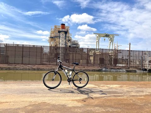
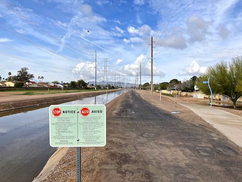
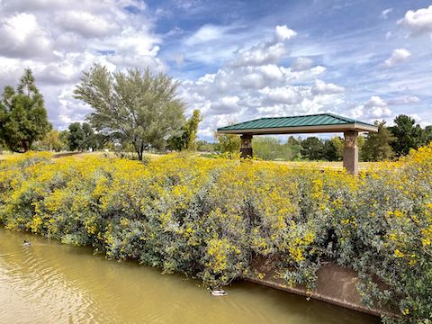
You can stay on concrete the next 11½ miles to Freestone Park. (For variety, I sometimes rode the gravel canal road, or even broken blacktop pavement.) There’s a Circle K and a McDonald’s at Kyrene Rd., if you need a drink, or to take a whiz. At 2¾ miles, the Maricopa Trail turns south on the east side of the Western Canal. Blue metal netting protects you from stray golf balls sliced off the adjacent course.
The Maricopa Trail turns east, between the golf course and Kyrene Generating Station. It soon switches to the south side of the Western Canal, and changes sides several more times thereafter. Just stay on the concrete path. East of Alma School Rd., the Western Canal becomes a muddy ditch.
At 3¾ miles, the Maricopa Trail crosses Rural Rd. Every mile thereafter, the Maricopa Trail crosses a major road: McClintock Dr., Price Hwy. (Loop 101), Dobson Rd., Alma School Rd., Country Club Dr. (AZ-87), McQueen Rd., Cooper Rd., Gilbert Rd. and Lindsay Rd. All the major roads have a bike crossing signal. The minor roads, just a hashed crosswalk. 🚦
The Maricopa Trail passes numerous small parks — Redden Park, Stroud Park, Palo Verde Park, Marlborough Mesa Park — but only the larger Carriage Lane Park (6 miles) and McQueen Park (10 miles) have restrooms. Several of the parks were underwater, as our Phoenix-area parks often serve as sumps for rain runoff. McQueen Park had a nice duck pond.
Starting at Monument Hill, the Maricopa Trail is collocated with Sun Circle Trail for 73 miles, past the Gila River Indian Community; across South Mountain, Tempe, Gilbert and Mesa; through the Salt River Reservation, to Scottsdale. (The Sun Circle Trail then splits northwest, along the Arizona canal, through Biltmore & Sunnyslope to Peoria, before turning south along New River, back to Monument Hill.)
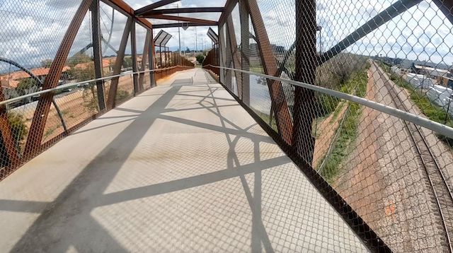
Maybe my favorite part of the day was zipping down the Maricopa Trail railroad overpass (above). My kart racing days paid off: At the bottom, I took the quick left-right at speed, without crashing. The next half mile skirts the north edge of downtown Gilbert. I enjoyed the smell of frying grease and dodging tourists on “electronic bikes”. Otherwise, bike & foot traffic was moderate.
The Maricopa Trail continues north along the west side of the Consolidated Canal East Branch, to an unprotected crossing. Instead, I used the signalled Lindsay Rd. crossing to access Freestone Park, where my supportive wife / shuttle driver was waiting for me with her haul of tasty Asian goodies from Lee Lee Supermarket in Chandler. I’ve now completed 154.43 miles of the Maricopa Trail.
Pima Canyon Directions: From Phoenix, head south on I-10. Take exit 157 west onto Elliot Rd. Stay right. Turn right onto 48th St. In 1 mile, turn left to stay on 48th St. Take the very next left onto Pima Canyon Rd. The Pima Canyon Trailhead is at the end of the road in ½ mile. Parking is free.
Freestone District Park Directions: From Phoenix, take US-60 east. Take exit 182 south onto Gilbert Rd. In ½ mile, turn left on Baseline Rd. In 1 mile, turn right on Lindsay Rd. In just over a mile, after crossing over the canal, turn left on Juniper Ave. Park in the first parking lot on the right.
GPS File: Maricopa_Trail_Pima_Canyon_to_Freestone_Park
Distance: 14.14 mi.
AEG: 116 ft.
Time: 1h 40m
Biking Video
Biking Maricopa Trail: Pima Canyon to Freestone Park from Preston McMurry on Vimeo.