
")
Tuesday, I was scheduled for my monthly Lunch With Mom in Casa Grande. Wednesday, I was supposed to be hiking Seven Springs to Cave Creek with LosDosSloFolks, from HikeArizona.com. But heavy day-long rain was expected north of Phoenix, so we cancelled.
Drizzle, at worst, was expected scattered around Casa Grande, so instead I decided to combine hike and lunch days, like I did back in October, sparing my always supportive wife an extra day away from home. Problem is, there do not seem to be a lot of trails, of any sort, in the Casa Grande area, other than the Casa Grande Mountains. 🤷🏻♂️
Google turned up a route on 18 miles west of Casa Grande, between Interstate 8 and the hamlet of Stanfield. I’m not yet a member of AllTrails, so couldn’t download the route. I figure what I hiked was a good estimate. The Hill 2308 Loop is, however, on State Trust Land, so a $15 permit is required. This hike isn’t worth the fee, but the permit is good Arizona-wide for a year.
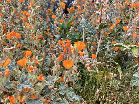
Driving south from Phoenix on I-10, there were tons of yellow flowers in the median, brittlebush and some other ground-hugging species. Also some lupine here & there. The flowers actually got better along I-8, the roadside fields filled with orange desert globemallow. So, despite the chilly overcast weather, I had high hopes for desert flowers!
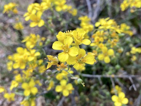
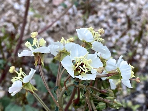
The first flowers I photographed were moapa bladderpod, mainly because it was so hard choosing from the abundance of Coulter’s lupine patches. Besides the flowers pictured above and below, I also photographed creosote, woolly daisy, brittlebush, fetid goosefoot, wild heliotrope, fairy duster and California suncup. (As if Arizona needs anymore refugees from that state.) 🙄
I hiked the Stanfield Hill 2308 Loop counter-clockwise, starting on a sandy road. There are lots of horse tracks, and a fair number of OHV tracks as well. The corners frequently had berms kicked up by OHVs.
The Stanfield Hill 2308 Loop is fairly straightforward, despite the many jeep trails which crisscross the area. Basically, if you keep Hill 2308 close to your left, as I did, you will be heading in the correct direction. The powerline will be ~200 yds. to your right, as the jeep trail heads northwest.
When the jeep trail turns west, towards stand-alone conical Hill 2031, it begins slowly climbing. That turn is where the alternate trailhead on Robin Rd. accesses the loop. There is a significant wash where the jeep trail reaches Hill 2031. Heading left, up the wash, shortens the Stanfield Hill 2308 Loop to four miles. 🗺
Despite the area being known for heavy smuggling activity, I only found two discarded jackets and one set of identifiable human footprints (heavy work boots). The main smuggler pass is apparently 1½ miles north, on the far side of Robin Road’s small lot ranches.
I stayed on the jeep trail as it turned right across the face of Hill 2031, joining the powerline road at the two mile mark. Just before the powerline turns north at a fenceless gate, I instead bent sharply back to the left, onto another jeep trail. 🛻
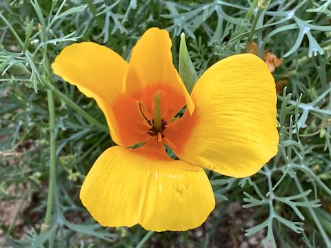
The jeep trail south of the powerline road had scads of Mexican gold poppy, and more moapa bladderpod than I have seen, total, my entire life. After a half mile of golden goodness, the jeep trail drops 30 slippery feet to join the shortcut wash I mentioned earlier. I turned right, upwash, away from Hill 2031.
The wash remained sandy, despite getting rather narrow. There were still OHV tracks in the sand. After climbing up a 5 ft. high slick rock section, the jeep trail resumed. The skies were getting even darker, and the wind beginning to pick up.
The wind peaked, gusting through the pass between Hill 2308 and Hill 2272. It blew my red Honda Performance Development hat off my head. The hat I’ve been hiking with almost five years, since I tossed the too greasy previous one after a kart race in Jacksonville. I was able to retrieve the Honda hat, but not keep it on my head, so I stuffed it down my shirt.
I may not have the latest digital SLR, yet I get good angles on my flower photos because I get down in the dirt. Aiming up is more dramatic, and I get closer to the subject. And that is how I ended up losing my hat. I ran back to where I thought I’d it fell out of my shirt, but with a 10:30 EndEx looming, had to give up my search. I put probably 3,000 miles on the Honda Hat. Farewell old friend … 😢
The speed with which I was moving, and the general ease of the terrain, is evidenced by my averaging a hair under 3 mph, finishing the Stanfield Hill 2308 Loop in exactly two hours. I was a few minutes behind schedule, but after a restorative V-8, and a quick change into fresh socks and a clean t-shirt, off we headed to the Casa Grande Cracker Barrel!
Trailhead Directions: From Phoenix, AZ-347 south through Maricopa is shorter, but I would instead take speedier I-10. From I-10, take exit 199 west onto I-8. In 26 miles, take exit 151 north, back and to your right, onto AZ-84. In ¾ mile, turn left onto Ralston Rd. In ⅓ mile, at the small hill before the powerline, turn left onto the dirt road / pullout. Park there. Alternately, continue ¾ mile, turning left onto Robin Rd. In 1 mile, turn left onto a dirt road / pullout. Park there.
GPS File: Stanfield_Hill_2308_Loop
Distance: 5.91 mi.
AEG: 434 ft.
Time: 2h 00m
Hike Video
Hiking Stanfield Hill 2308 Loop from Preston McMurry on Vimeo.