

Counter-clockwise from Bronco Trailhead, this is the 19th segment of the Maricopa Trail.
After recently completing the Chesapeake and Ohio Canal and Black Canyon Trail, this week I was back to work on hiking & biking the Maricopa Trail, a 315-mile trail system in & around the massive Phoenix metro area (aka The Valley of the Sun). The loop itself comprises 245 of the 315 miles. Many miles of the Maricopa Trail are canals, sidewalks, and similar flat terrain — which I am biking. 🚴🏻♂️
I plan on doing one Maricopa Trail segment every 3-4 weeks, from November through April, when I will hike the final segment from Bartlett Dam Rd. to Bronco Trailhead, near Seven Springs.
Today’s Maricopa Trail bike ride was from Granite Reef Dam to the Detroit Coney Grill on the southeast corner of Hayden Rd. and Indian Bend Rd., in Scottsdale, just north of the Arizona Canal. Why Detroit Coney Grill? Because my favorite comedian, Dave Landau, is from Detroit and I’ve heard him rave about the Coney-style hotdogs.
It was a cool 61℉ when I started pedalling at 9:07. But after the first five minutes, I no longer noticed. The weather was perfect.
From the Bush Highway Trailhead, the Maricopa Trail zips downhill. At ¼ mile, it turns left through a vehicle gate, then right along the south side of a spillway. There’s lots of “No Trespassing!” signs to either side, but as long as you stay on the road, you are okay. A security guy even said hello to me! 🙂
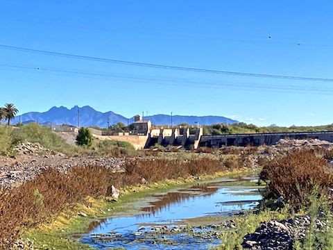
At ¾ mile, the road bends right towards the South Canal. After crossing the South Canal, if you turn left, you will be heading towards Park of the Canals in Mesa. (The 18th segment of the Maricopa Trail.) Instead, continue straight, across the Salt River basin. The descent is steep, but short, simultaneously both rocky & sandy. Not for the last time, my ball joint-mounted GoPro was knocked out of alignment.
Having stopped to take long-distance photos of Granite Reef Dam, I walked my bike up the Salt River’s north bank. At the top of the bank, turn right for a closer Granite Reef Dam photo; I turned left, heading west.
As far as bike riding goes, the Maricopa Trail was fairly smooth. Typical dirt canal path surface. Though I stopped many times to change GoPro Hero 10 camera angles, I stopped at least three extra times in the next couple of miles because even minor gravel bumps would rotate my camera clockwise away from my direction of travel. It’s a good thing the segment is little travelled, because I cursed up a storm. 🤬
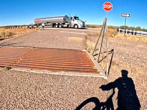
At 4¾ miles, Maricopa Trail crosses AZ-87 / Beeline Highway. There is no tunnel, traffic light, or median island. You have to play Frogger. Tightly edited, my well-timed crossing would have made an interesting video sequence. Unfortunately, my GoPro Hero 10 decided to turn itself off. (Probably while I was yet again fixing the rotation: The power button is where you grip the camera.)
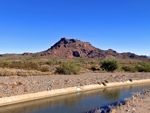
After crossing AZ-87, Maricopa Trail parallels Beeline Highway for about a mile, before bending away to curl around the Salt River Landfill. (The Arizona Canal path right-of-way crosses the Salt River Pima–Maricopa Indian Community.) It’s 1½ miles of scenic beauty.
A mile past Salt River Landfill, Maricopa Trail enters farm land. At least on the north side of the Arizona Canal. The south side, where the trail is, is large lot residential. At 8½ miles, there is a diversion dam that feeds water to the reservation’s farms. 🚜
After AZ-87 / Beeline Highway, Maricopa Trail crosses four other roads: Mesa Dr. (9 miles), Alma School Rd. (11⅔ miles), the Loop 101 / Pima Freeway (13 miles) and Pima Rd. (13½ miles). Mesa Dr. and Alma School Rd. are very low traffic on the reservation, so the unprotected crossings are no problem. Also unprotected, Pima Rd. has moderate traffic. The Pima Freeway has an underpass.
After crossing Pima Rd., Maricopa Trail turns right onto a bi-directional cement bike path, delineated by a dashed line, just like roads have. (Instead of turning right, you could go straight, remaining on the dirt south side of Arizona Canal.) Turn left after crossing the bridge over Arizona Canal. The final mile splits the difference between Arizona Canal and Scottsdale Silverado Golf Club.
When you get to Hayden Rd., split left and up. At the top, turn right / north on the sidewalk. (The road has heavy, fast, traffic.) Detroit Coney Grill is the orange-trimmed building on the right, just over the bridge. 🌭
Panic ensued. My iPhone was missing! (My bike short pockets are shallow, and have an awful angle.) Thankfully, I only had to double back ¾ of a mile, before finding it next to the golf course. Praise jeebus!
I’ve now completed 185.71 miles of the Maricopa Trail.
Bush Highway Trailhead: From Phoenix, take the Red Mountain Freeway (Loop 202) east. Take exit 23A east to Power Rd. Turn left. In 2⅓ miles, as the road curves right, turn left into the Bush Highway Trailhead. There is no fee. Or continue ¼ mile, then turn left into the Granite Reef Recreation Area, which has toilets, picnic tables, etc. and requires an $8 Tonto Day Pass.
Detroit Coney Grill: Southeast corner of Hayden Rd. and Indian Bend Rd.
GPS File: Maricopa_Trail_Granite_Reef_Dam_to_Detroit_Coney_Grill
Distance: 17.22 mi.
AEG: 117 ft.
Time: 2h 13m
Rumble Video
Vimeo Video
Maricopa Trail: Biking Granite Reef Dam to Detroit Coney Grill from Preston McMurry on Vimeo.