

As I discovered hiking the White Mountain Trail System (WMTS) the last two years, Show Low and Pinetop-Lakeside get pretty toasty mid-day in June. Hoping for somewhat more moderate temperatures, I moved my annual visit up two weeks. 📆
The temperature was especially important as Lookout Connector Trail traverses the Rodeo-Chediski Fire burn area. I could see on satellite view where there are surviving stands of pine, and where trees had been replaced by manzanita. I got sun burnt anyway, so I may hike the WMTS even earlier in 2023.
It was also warmer because I started hiking at least an hour later than I planned, due to missing the AZ-260 turn off to Joe Tank Rd.. Thinking Joe Tank Rd. was between Show Low and Pinetop-Lakeside, I ended up driving nearly 20 miles south to the White Mountain Apache reservation. Don’t make the same mistake: Check out the driving directions at the end of this blog.
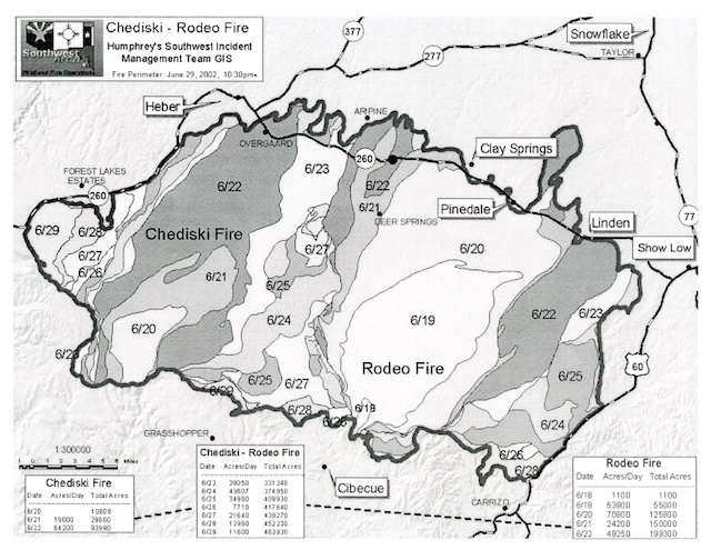
Lookout Connector Trail is an unnumbered trail in the White Mountain Trail System, which gets its name because it connects Los Caballos Trail #638 to Juniper Ridge Trail #640. South-to-north, Lookout Connector Trail is 4.0 miles, 840 ft. accumulated elevation gain (AEG); north-to-south, it is 425 AEG. Round trip from Joe Tank Rd. is 9.5 miles, 1400 AEG.
From the trailhead on Joe Tank Rd., head west for 200 yds. on Los Caballos Trail #638. At the LC 23 blaze, turn left onto double track / jeep trail through healthy gambel oak, small juniper and scattered manzanita. After another ½ mile, just past LC 25, Lookout Connector Trail, marked by an obvious yellow-painted sign, is on the right.
I was at first confused by the blazes, thinking “LC” was Lookout Connector Trail, which is actually blazed “LK”. The black-on-white, reflective, diamond-shaped blazes are posted roughly every ¼ mile, counting down to the summit of Juniper Ridge. There are also simple “White Mountain Trail System” blazes, and some no-OHV markers. I often found them having fallen on the ground. Plenty of signs!
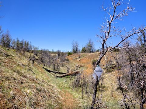
Lookout Connector Trail crosses a half dozen 50-100 ft. spurs before making the final 400 ft. climb up Juniper Ridge. The lightly-travelled single track intermittently disappears in the grass, and is often crossed by alternate foot trails. Combined with the occasionally grounded blazes, it’s easy to wander off course. If you are not skilled at “reading sign”, download the GPS track below. 🧭
Lookout Connector Trail also crosses at least 10 jeep trails. The main ones to keep in mind are FR 136 (aka Joe Tank Rd.), which crosses the trail between LK 11 and LK 10; FR 9807K near LK 7; and FR 9807L, between LK 6 and LK 5. All three can be easily used for a quick pickup after bailing. The latter two being accessible via the Timberland Acres inholding, a mile south of Linden’s Mormon temple.
Flower coverage was light. There were a fair number of alpine false spring parsley along Los Caballos Trail #638 and fleabane along Lookout Connector Trail. The highlight was spotting what I thought were several dozen scattered Gunnison’s Mariposa Lily. (The only other one I’d seen was, ironically, on Juniper Flat in the Sierra Ancha, 50 miles southwest.) Instead, they were doubting mariposa lily.
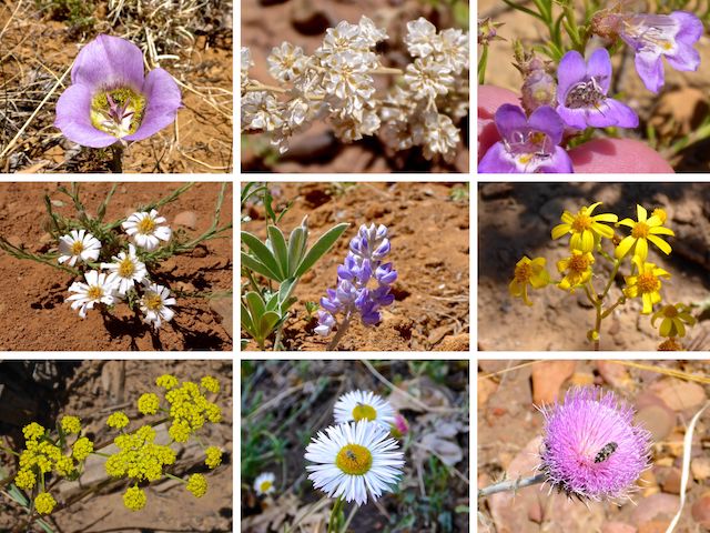
Top Row: doubting mariposa lily, ceanothus?, toadflax penstemon.
Middle Row: baby aster / rose heath, silvery lupine, New Mexico groundsel.
Bottom Row: alpine false springparsley, spreading fleabane, New Mexico thistle.
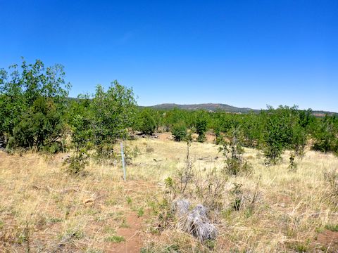
Lookout Connector Trail has no real shade to speak of. I counted three small stands of surviving, spot shade-providing, pine trees in the 1¼ miles between LK 9 and LK 4. Otherwise the vegetation is similar to Los Caballos Trail #638, but less dense. I only saw a few small prickly pear cacti. ☀️
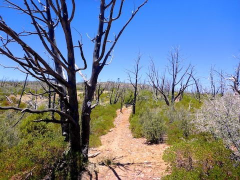
Manzanita (“little apple”) are a shrub with stiff, twisted, orange or red branches. The wood is fire resistant, but manzanita need fire to germinate. And germinate they have since the Rodeo-Chediski Fire! Though there are spot manzanita earlier on Lookout Connector Trail, the FR 9807K spur and the final ¾ mile climb up Juniper Ridge are particularly thick with them.
Earlier in Lookout Connector Trail, most of the burn trees had fallen. Heading up Juniper Ridge, the dead still stand: their blackened branches vainly beseeching the heavens. The trail ends at a t-intersection, a few yards past blaze LK 1. Right to Juniper Ridge Trail #640; left to the fire lookout.
I’m not real comfortable meeting new people, so I never ask a fire lookout if I can come up for a visit. I’m sure since the Chinese Lung AIDs, and now the Monkey Pox, the Forest Service might not even allow stranger visits. Finding a fence around the Juniper Ridge fire lookout made it easy to avoid being asked. Even on the ground, there are great views from northeast to southwest.
While I ate lunch, I checked my Verizon reception: My iPhone SE had 1-2 bar LTE. (3 bars LTE at the trailhead!) It was enough to text my wife that a photo and tell her I was on my way back. Other than swapping water bottles, and photographing a few late blooming flowers, I can’t recall stopping on the return trip. 🛰
On way back up Joe Tank Rd. to AZ-260, we passed Apache-Sitgreaves National Forest Engine 372. I asked the captain if they had smoke, and he replied just a snag. Whew. Last thing the area needs is another blowup!
Directions: From Phoenix, head north on AZ-87, the Beeline Highway, into Payson. Drive east on AZ-260 for 84.4 miles. As AZ-260 tops the ridge between Linden and Show Low, just past MP 337, turn right onto Joe Tank Rd. The road is paved for ¼ mile, before turning to car-drivable dirt as it enters the Apache-Sitgreaves National Forest. Just under four miles from AZ-260, as you break out of the tree line, there is a lone burnt tree sticking up. Park anywhere you can find shade in the dusty turn-around.
GPS File: Lookout_Connector_Trail
Distance: 10.08 mi.
AEG: 1,314 ft.
Time: 3h 49m
Hiking Video
Hiking Lookout Connector, WMTS from Preston McMurry on Vimeo.