

My first “away” mountain bike ride, for which I prepared by riding what I call the Mega Church Loop, around mostly flat Moon Valley and Sunnyslope. The lasso part of this loop is shorter, but with one good climb and several smaller ones. I maybe could have done that, but my brother Chris — who is a much more experienced rider — threw in a diversion to Potato Lake that zapped me.
From Fortyfour Canyon, we rode FR 613 past Windfall Spring and Dirtyneck Canyon 4.4 miles to FR 147. There are climbs of 80 (3.8%), 70 (3.7%) and 90 ft. (3.3%) along the way. We turned right on FR 147. From there it is only a few hundred feet to FR 612, but Chris — who originally wanted to to do the loop twice — WTF!? 😳 — suggested a diversion to Potato Lake, so I compromised and went along.
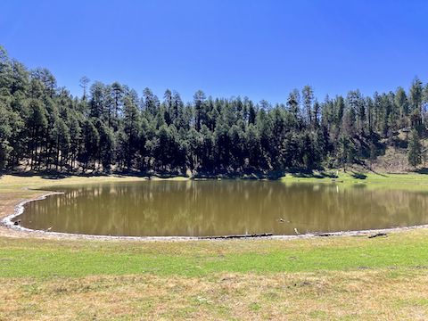
We rode FR 147 down, over Poverty Draw, and along East Clear Creek across Poverty Flat. There were drops of 100 (5.7%) and 80 ft. (5.0%). Potato Lake is ½ mile up FR 147B, past first a “no motor vehicle” gate, then next to the lake a “no bikes or horses” gate. Potato Lake looked about 25-33% full. On the way back, I made it up the first climb, but had to push the second. Either way, it’s exercise. 😉
Afterwards, we doubled back to FR 612, taking that past Dry Lake, then down FR 141 across Long Valley, which descends 300 twisty feet in a mile (5.7%). I braked often, Chris probably did not. When I asked him what the grade was on his Strava, he said he didn’t know because “I was too busy trying to stay alive.” 😆
We turned south on FR 147, past the Long Valley work center. What goes down, must unfortunately go up (300 ft. but in twice the distance of the descent.) I struggled, walking twice. It wasn’t just my cardio affecting me, but my shoulders were agonizing. I was riding a new bike, with wider handle bars, so maybe that was it? 🤔
After we turned back onto FR 613, I could no longer keep up. Chris rode ahead to bring back his SUV, while I slowly followed.
If you want to bike the Long Valley Loop, the lasso is 8.9 mi., 535 AEG; the loop is 6.8 mi., 445 AEG; and the diversion to Potato Lake is 5.7 mi., 355 AEG. Total for the whole package? 21.4 mi., 1335 AEG.
Directions: From Phoenix, head north on AZ-87, the Beeline Highway, through Payson, Pine and Strawberry. (Alternately, take I-17 north, then AZ-260 east.) 4.4 miles north of AZ-260, turn right onto FR 613. In 0.4 miles, Fortyfour Canyon is at the bottom of the first dip. Park in the open area.
GPS File: Long_Valley_Loop
Distance: 19.33 miles
AEG: 1082 ft.
Time: 3h 08m
Biking Video
Mountain Biking Long Valley on Mogollon Rim from Preston McMurry on Vimeo.