

2019 was a tough year for me in terms of consistently getting out for ‘away hikes’, so after hiking the Black Canyon Trail last week, it was good to get out for a second week in a row!
I have my hikes generally planned through April, when I will be doing two more segments of the Chesapeake & Ohio Canal Towpath. This week I was scheduled to to do a mine explore, but to be honest, even though I only do a few of them a year, I’m kind of burned out on mine exploring: Too much research to get done for an upcoming mine explore after completing all the post-hike work I do (blog, photoset, GPS route, video, etc.). Like I said, I’ve found it hard enough getting out to do regular hikes on a consistent basis. 😕
I knew Kaiser Hot Spring was near Burro Creek Campground, but I did not relish a rocky, and possibly quite wet, 12-mile roundtrip between the two. Plus, I did not want to get shot at. (In 2018, Danny Button was sentenced to 22 years in prison.)
After doing some satellite recon, I came up with a route from US-93, down Warm Spring Canyon, to Kaiser Hot Spring (aka Warm Spring, itself). But the route is only 3.4 miles round trip — meager exercise on a 4-hour roundtrip drive from Phoenix — so I added a jeep trail loop up an unnamed mesa.
Hiking from US-93 to Kaiser Hot Spring is easier than hiking in the Phoenix Mountains Preserve. Seriously, anyone without a zimmer frame could do it. ♿️
From the trailhead, pass through the gate and under US-93. There is a trail down to Warm Spring Canyon. It’s a bit slippery, but only 30 ft. and not bad. Once in the wash, follow it west. The first mile, to the bottom of FR 7519, is wide, sandy and shallow. Just before FR 7519, there was a trash pile that in 2013 was an A-frame tent covered in plastic sheeting.
There was a retired couple camping at the junction of Warm Spring Canyon and FR 7519. I announced myself before passing by, on my way up FR 7519.
The jeep trail splits left (FR 7519) and right. I went right, counterclockwise, which was good for walking, but rough for a jeep trail. The gnarly spots require a proper OHV for driving. It was a steady 1.7 mile climb to US-93, during which some sun started breaking out. At the top, I could see Wikieup through a highway cut in a nearby spur. 🔭
I turned west on what I discovered to be FR 7519. (Actually a BLM road, but I have no idea what prefix those have.) There were great views all along FR 7519. It was obvious the dirt road had been recently scraped. I would have had no problem driving it in my SUV. After ¾ of a mile, FR 7519 started heading back down toward Warm Spring Canyon.
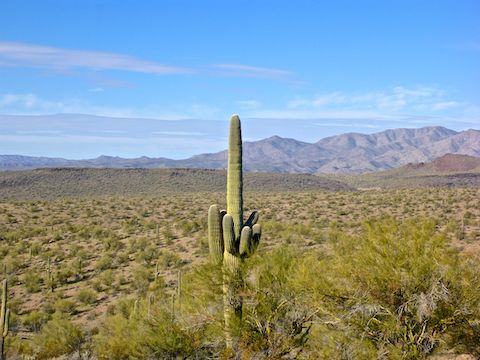
FR 7519 was not steep, but there were a few rocky sections. I saw two separate burros, but they moved too quick to get a decent photo. I also spotted an absolutely enormous ocotillo, easily 15 ft. tall! (Waymarked on the GPS route attached below.)
Passing back by the campsite, the retired couple and I had the first of several conversations we would have as we hop-scotched each other down to Kaiser Hot Spring, Burro Creek, and then back. (I filled them in on how wonderful Aravaipa Canyon is: I have to get back there one of these days!)
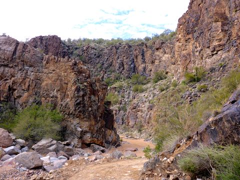
The final ¾ of a mile in Warm Spring Canyon, from the bottom of FR 7519 to Kaiser Hot Spring, are the highlight of this hike. Simply spectacular canyon walls! 😳
I took my time, looking backwards, up & around. Blown away, I took a jillion pictures of Warm Spring Canyon’s walls. There were a ton of caves to explore, some without too much climbing.
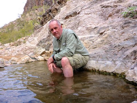
Kaiser Hot Spring itself is not large, but it was gushing so much water that the overflow trickled all the way down to Burro Creek. I wanted to check out Burro Creek Mine before getting my feet wet, so I passed by.
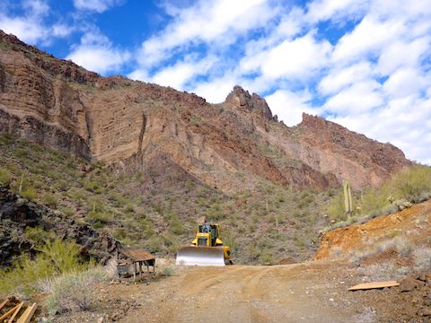
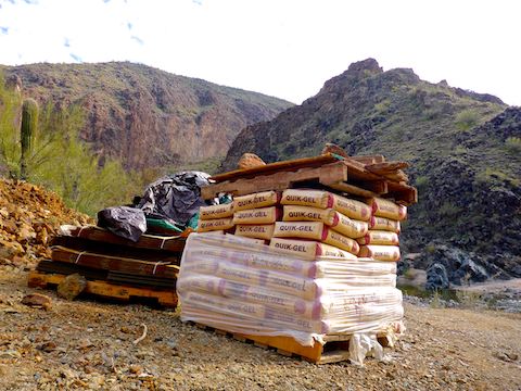
Just past Kaiser Hot Spring, there were a bunch of warning signs. According to the Arizona Geological Society, Burro Creek Mine had not been worked since the early 90s — the 1990s, that is — but the signs and the earthmovers clearly indicated otherwise. I decided to proceed.
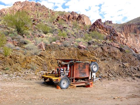
Between Kaiser Hot Spring and Burro Creek, there were multiple 20 liter containers of QUIK MUD D-50 (a borehole stabilizer) and Di-Corp Earth Pro TurboCut (a borehole tool lubricant), a pallet of Quik-Gel (a viscosifier for borehole solids), a work table, the usual miscellaneous mine tools and containers, what appeared to be a pump on wheels, and a stack of cardboard boxes containing marked core samples. Though I neither saw, nor heard, any mining activity, Burro Creek Mine was clearly active, not just some placer mining desert rat.
Later research proved me correct, as Sitka Gold Corp. of Vancouver, BC, has assumed ownership of the Burro Creek Mine claims, and is in the midst of a $1.3 million exploration effort. There are four patented claims, and 30 unpatented, totalling 650 acres, stretching two miles from FR 7519 on top of the unnamed mesa, southeast across Warm Spring Canyon, and along Burro Creek to Andy’s Hole.
I’ve read the 56-page Burro Creek Mine geological report, and Sitka expects to extract as much as 200,000 ounces of gold, from ~5 million tons of ore. Gold is currently over $1,500 per ounce. Even at the 5-year low of around $1,000, that would be $200 million in revenue. Strip mining is authorized on their claims, so with that kind of money at stake, it’s going to happen. Visit Warm Springs Canyon while you can! 😥
I could not cross Burro Creek dry, and did not want to go to Federal Pound Me In The Ass Prison, so I doubled back to Kaiser Hot Spring.
As I mentioned, Kaiser Hot Spring is also referred to as Warm Spring, which is more accurate description of the water’s temperature. The pool is small, and only calf deep, but the bottom is soft, and safe to walk in, so you can sit & soak, but not swim. I ate lunch and relaxed with a hiking beer.
After lunch, I made short work (37 minutes) of the 1.7 mile hike back up Warm Spring Canyon to US-93, where a small herd of burros were keeping watch over my patient wife.
US-93 Trailhead: From Wickenburg, drive north on US-93 for ~63 miles to mile marker 135, just over the second big bridge. There is a highway crossover there. Turn right (east), onto the unnumbered dirt road. In a few hundred yards, turn left before the gate, then park. This way is bumpy, but car accessible.
4×4 Alternates: At mile marker 134.5, southbound US-93 only, there is a dirt road to the right (west). The 80 ft. road up is steep, but not bad. At the top: 1) Turning left is 4×4 HC and with several gnarly spots. It is 1.7 miles to the creek bottom. Or 2) At the top, continue west on FR 7519, which has some rough spots, but is not bad. Kinda like FR 172 to Woodbury TH. It is 2.1 miles to the creek bottom. The creek bottom road is being maintained by the Burro Creek Mine operation.
GPS File: Kaiser_Hot_Spring
Distance: 8.60 mi.
AEG: 931 ft.
Time: 3h 33m
Hike Video
Kaiser Hot Spring & Burro Creek Mine from Preston McMurry on Vimeo.