

This was my first time in Sierra Ancha since hiking Tanner Peak nearly a year ago.
The Sierra Ancha’s blessing & curse is that it is so remote. McFadden Peak is 67 miles, as the buzzard flies, from Sunnyslope, but it takes three hours to drive there. (And that is when one considers the speed limit optional.) The only improved road — and half of it is dirt — is AZ-288, which runs from the east end of Roosevelt Lake to the hamlet of Young, then continues as FR 512 north to AZ-260 on the Mogollon Rim, just east of Woods Canyon Lake.
You may know the Sierra Ancha better as the site of the Pleasant Valley War, a classic cattlemen versus sheepherders feud that resulted in dozens of deaths from 1882-1892. (The feud only ended when there was but one man left alive.) Young, just north of McFadden Peak, was at the center of the feud.
Elephant Rock Mesa was also my first ‘away hike’, since East Mountain Trail #214, in the Pinal Mountains, three weeks ago.
Why? Because the World Cup was on and life has priorities. But I made up for the lack of away hikes by doing walks & short hikes around my North Mountain hood for 33 straight days. (Ironically, North Mountain itself is closed for trail construction until the end of 2018.)
In fact, in the first six months of 2018, I have done 121 exercise events, totalling 433.75 miles and 48,049 AEG. The most walks, hikes & bike rides I’ve ever done in a year was in 2017, and that was ‘only’ 143.
My plan was to park at the bottom of the McFadden Peak Lookout access road, hike east to Elephant Rock, explore the mesa, overlooking Cherry Creek, climb up to the arch, then loop clockwise back to the trailhead. That way the scramble up to the arch would only be 360 ft., rather than 800 ft. from the bottom of a small canyon. I also expected to find two sets of what I assumed would be ranch ruins.
The hike to Elephant Rock Mesa starts by heading southeast from the trailhead on what appears at first to be jeep trail. After passing through a gateless fence 50 yds. from where I parked, the jeep trail petered out. From there, the hike is relatively easy bushwhacking, rocky in spots, but rarely threatening the structural integrity of one’s joints. Try to follow the contour line, and not get too far up or down slope.
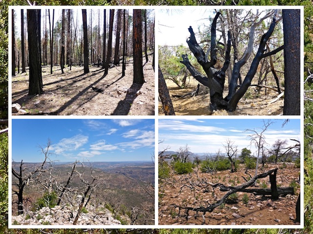
It was immediately obvious I had entered a significant burn area. (Either from 2000’s Coon Creek Fire, or maybe earlier, judging by vegetation recovery.) Despite many significantly damaged large trees, there was still plenty of shade from a mixture of pine and deciduous trees.
In .30 miles, I crossed into the Sierra Ancha Wilderness. If you are following the attached GPS route, you will pass right by the black-on-yellow wilderness sign.
If you skip scrambling up to Elephant Rock Arch, as I ended up doing, the 6490 ft. high point of the hike is reach at .60 miles. I then crossed two small, but steep, washes, before finding the first ruins.
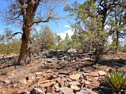
Given the ruins were on a mild slope, not in a defensible cliff or on a hill with extensive views, I was expecting the ruins to be an old ranch, not indian. But Indian they were, as evidenced by the piles of rough rock jumbled about. No identifiable walls remained. Judging by the size of the piles, the ruins housed a small family, rather than a tribal group. I did not find any pottery sherds, metate grinding stones, arrowheads, or any other artifacts.
Elephant Rock Arch was easily visible from the ruins, a half mile southeast. (Both Google Maps and the map on my GPS have misplaced the arch, in a location just yards from the ruins.)
Rather than head straight into the third wash from the ruins — which was a rocky route — I went to the side, finding an easy cattle path down. The third wash is actually an unnamed canyon, the head of which is McFadden Horse Mountain, 1.5 miles south. The canyon forms the west and north sides of Elephant Rock Mesa, before emptying into Cherry Creek.
I had heard there were more ruins in the canyon, below Elephant Rock Arch. (Which would have been an even odder location than the first ruins.) But I never saw anything even vaguely resembling ruins. indian or otherwise.
The canyon bottom is not nearly as congested as one might expect. Certainly much less so than lower Crackerbox Canyon. I turned north, to the left, heading gradually downward. That is not a problem, because the top of Elephant Rock Mesa also slopes down to the north. Despite going down, I was actually getting closer to the rim of the mesa!
I bumped into a half dozen cattle, who scattered down canyon ahead of me. I followed their splattery panic poos for a few hundred yards.
In a quarter mile, I found a cattle path heading up sixty easy feet to the ‘rim’. You should avoid heading much further down canyon, as it soon becomes much deeper, with sheer walls.
I had intended to follow the rim all the way around Elephant Rock Mesa, but the cattle path took me to the mesa’s interior, rather than north. If you want to follow the rim, it would be easy, as the mesa top is free of serious obstacles, rocks or even grab & stabs. In fact, there were almost no cacti, other than a few ping pong ball-sized fuzzy cactus. Most of the stabby plants were agave. Despite extensive fire damage, it was still easy to find shady spots.
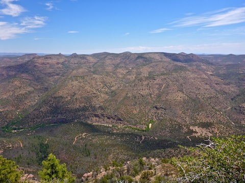
I took my first break, sitting on the canyon rim, at Photo OP 1. (You can read “OP” as either op, as in opportunity, or as observation post.) The views were amazing, and only got better as I worked my way around Elephant Rock Mesa.
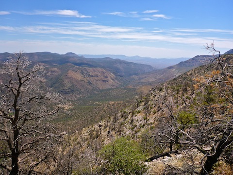
Working my way over to Photo OP 2, at the mesa’s northeast corner, I ran into the same herd of cattle I had encountered in the canyon. There was quite a bit of fire damage at Photo OP 2, making it hard to get decent photos up Cherry Creek, without getting dangerously close to the crumbly rim.
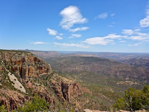
Photo OP 3, on Elephant Rock Mesa’s east rim, had much better views, up & down Cherry Creek, and east towards the White Mountain Apache Reservation.
However, Photo OP 4 was the pick of the crop, both for canyon views, and views of Elephant Rock. Down in Cherry Creek, FR 203 was obvious, and there was quite a bit of green, leafy, trees. Wish I had a vehicle that was capable of handling that rugged forest road.
There is a cairn at Photo OP 4. No idea why, as it is not the mesa’s ‘summit’. I did not find a log in the cairn.
It was 12:30 p.m., and already in the high 80s, so I decided to forgo scrambling 360 ft. up to Elephant Rock Arch. Instead, I headed back to the cattle trail, took another break, then backtracked to the trailhead on AZ-288.
On our way back to Phoenix, my wife & I stopped at Big Daddy’s Pizza, in Tonto Basin, at the west end of Roosevelt Lake. Despite starving, I could barely cram down two slices, they pile on so much cheese & toppings. Big Daddy’s is for sale, so hopefully they find a good buyer!
Directions: Depending on where you live in the Valley, there are two general ways to get to the Sierra Ancha: From the south & east Valley, take US-60 to Globe, then AZ-188 north towards Roosevelt Lake. From other parts of the Valley, exit the Loop 101 at Shea. Go east on Shea to the Beeline Highway (AZ-87). Go north on the Beeline Highway for 46 miles to AZ-188. Go east on AZ-188 for 46 miles, passing through the small communities of Jake’s Corner, Punkin Center, Tonto Basin and Roosevelt. Turn north onto the Young Highway (AZ-288). The road is narrow & twisty as it climbs into the Sierra Ancha, so mind your speed. In ~22 miles, as AZ-288 crests the climb, it turns to car drivable dirt. In ~9 more miles, just past FR 561 to the McFadden Lookout, on the right will be a pullout. Park there. You’ll need an SUV to cross the shallow ditch at the edge of the road.
GPS File: Elephant_Rock_Mesa
Distance: 7.04 mi.
AEG: 954 ft.
Time: 4h 13m
Hiking Video
Hiking Elephant Rock Mesa, Sierra Ancha from Preston McMurry on Vimeo.