

I’ve never been to the Hawes Trail System before. You just don’t hear aboout people hiking it much. It’s popular with mountain bikers. Maybe they talk about it a lot, but I don’t hang out on MTB forums. Yet, unlike some primarily MTB trail systems — e.g. McDowell Mountain Regional Park — Hawes is open to all non-motorized modes of transportation, including hikers. 🐴
I put together an almost 10-mile loop of Hawes Trail #52, Cactus Garden Trail, Red Mountain Rush, Sunset Ridge Trail, Twisted Sister Trail, Saguaro Trail #50, and Ridge Trail #59. (No idea why some trails are unnumbered.) I was originally going to hike my Hawes Trail System loop last week, but other priorities came up. Instead, I published my first Sunnyslope Murder Tour.
This week, I headed out early to beat rush hour. It was still dark when I arrived in Mesa at 7:00 a.m., so I stopped for breakfast at the Waffle House across from Falcon Field. The only other customers were three (other) old retired guys talking, loudly, about Dr. Hook and Rolling Stone. Didn’t have the heart to tell them they were off by 45 years.

Properly fortified, I arrived at the Bush Highway Trailhead just before 8:00 a.m. I thought I’d downloaded my intended Hawes Trail System loop to my GPS, but NOOO … Fudge. Fiddlestix. And other words inappropriate for young families. (Those words go in my Kingsnake’s Dashcam videos.) 😉
I wasn’t going to drive 35 miles home, so I decided to wing it. (Both my intended route and actual track are in the GPS file attached below.)
I started off by crossing Bush Highway, then a mountain bike rollover gate. Down in the wash, I turned right, to stay on trail. It was quickly obvious that although the trail was great for hiking, it was beyond my minimal biking capabilities: The minor wash crossings, though not high, were steep.
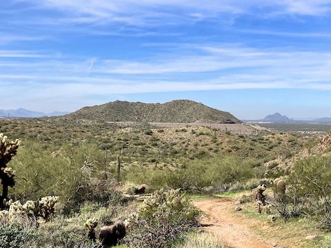
I made the first of many wrong turns ⅓ mile out, near a second highway-adjacent rollover gate. Hawes Trail #52 splits the difference between a major wash and the Fannin-McFarland Aqueduct as it heads south. I was hoping for an elevated view of the Salt River Gila Pumping Plant, but no such luck.
There are trails spider-webbed all over the Hawes Trail System. Most of the intersections are signed in some manner, though not always clearly. If you lose your way, just head in the general direction of Red Mountain: Eventually, you will hit the Bush Highway. At one such intersection, 1¼ miles out, there was a rest area with logs etched H-A-W-E-S. But it was early in my day, so onwards I hiked.
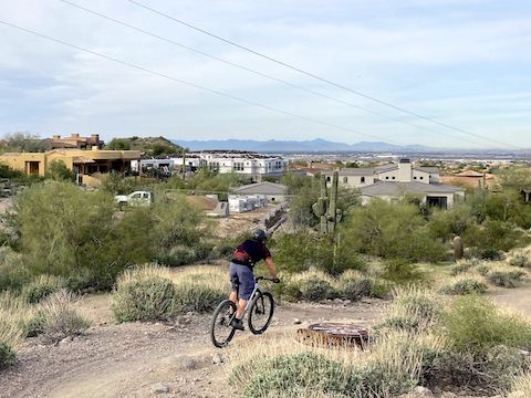
At 1½ miles, Hawes Trail #52 turns east at the high-end Las Sendas community, which is tight against a 300 ft. hill. I “remembered” the trail continuing straight, but instead it turned north, to curl around the hill, which confused me. I wasn’t lost, I just thought I’d somehow wandered off the route I failed to load onto my GPS. All along Las Sendas, there are concrete posts marking buried fiber optic cable. ⚡️
At 2¾ miles, unsure which way to go, I split left onto Saddle Trail #51, then soon after split right onto Magic Mountain Trail. Though only ⅓ mile long, Magic Mountain Trail’s boulders were the highlight of my day. It was also where I saw my first desert flowers other than fiddleneck. Overall, coverage was very sparse, but fiddleneck was the most common. The only species I didn’t photograph was lupine.
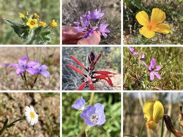
Top Row: fiddleneck, blue dick, Mexican gold poppy.
Middle Row: lesser yellowthroat gilia, scarlet bugler, redstem storksbill.
Bottom Row: white woolly daisy, distant phacelia, red and yellow pea.
The “far” end of Magic Mountain Trail is anchored on Hawes Trail #52. Rather than continue as intended, and make more wrong turns, I decided to start working my way back towards Bush Highway. First, I doubled back down Magic Mountain Trail, then continued north on Saddle Trail #51.
Several times, I considered taking a shortcut down a wash, towards Red Mountain, but stuck to the endlessly MTB-optimized twisting trails instead. I say “optimized”, and they are, but they would be challenging rides even for riders more skillful than I. Riding wise, Saddle Trail #51 is rated black diamond. I think that is fair: Even for hiking, it was uneven & slippery. I almost fell several times. 😬
At 5 miles, Saddle Trail #51 terminated at Saguaro Trail #50. I turned left, southwest, downhill. Besides Red Mountain, another good landmark is the Fannin-McFarland Aqueduct levee on the west side of Bush Highway, at the base of Schlechts Butte: That’s where the trailhead is. Unfortunately, Saguaro Trail #50 kept dragging me southwest, rather than turning towards the levee.
At 6 miles, I arrived at an unnamed bike repair station. Unlike Jackass Junction on the Pemberton Trail, there was no kitsch, sun shelter or picnic table. A four-way intersection, I was unsure which way to go. I headed right, towards Red Mountain. (Left is a half mile to the H-A-W-E-S logs.) A third mile north of the repair station, the trail splits. I went right, towards Red Mountain. Left is slightly shorter, but twistier.
At 6¾ miles, there was another four-way intersection. I didn’t want to hike to the Salt River, so again I turned southwest towards the levee. Thankfully, the switchbacks were over, and I was done with my Hawes Trail System loop 15 minutes and less than a mile later.
Even though I hiked less distance and AEG (accumulated elevation gain) than I intended, for some reason I was sore the next 48 hours. Just goes to show, being in biking shape is not the same as being in hiking shape!
Bush Highway Trailhead: From Phoenix, take the Red Mountain Freeway (Loop 202) east. Take exit 23A east to Power Rd. Turn left. In 2⅓ miles, as the road curves right, turn left into the Bush Highway Trailhead. There is no fee. Or continue ¼ mile, then turn left into the Granite Reef Recreation Area, which has toilets, picnic tables, etc. and requires an $8 Tonto Day Pass.
GPS File: Hawes_Trail_System_20240227
Distance: 8.52 mi.
AEG: 1,051 ft.
Time: 3h 17m
Rumble Video
Vimeo Video
Hawes Trail System Hike from Preston McMurry on Vimeo.