

Less than an hour from my home in Sunnyslope, Governors Peak is not far from Phoenix. The trailhead is on a dirt road, but one that is easily car-drivable. (Unlike the always busy, but bumpy, First Water Rd., where I’ve actually dropped car parts.)
The hike to Governors Peak is obvious and well-cairned. The trails are named, but unsigned: Spring Valley Trail, Hermit Trail and Bell Trail. And it is even shorter to the summit than Maricopa Peak — only three miles. But it does climb over 1,800 ft., half of that in the final ¾ of a mile. 😅
So, though local, Governors Peak is not really a locals hike. All the more so, because it is in an actual wilderness, the 9,951 acre Hells Canyon Wilderness. (Not to be confused with the much larger Hells Canyon Wilderness on the Snake River between Idaho and Oregon.)
Since Governors Peak is so close to Sunnyslope, I ate breakfast at home, instead of picking up QT. Driving past Lake Pleasant on Castle Hot Springs Road, the only confusion I had was when the road makes a 90° turn to descend to Garfias Wash. (Left goes to Spring Valley.) Garfias Wash had water for hundreds of yards upstream of the bridge, as Lake Pleasant’s water level is currently 30 ft. above “full”.
Also, if you are following any OHVs, chances are they will turn right a ½ mile north of Garfias Wash: Stay straight to continue on Castle Hot Springs Rd. ⬆️
Parking at the small pullout just past the cattle gate, I could see the white backcountry sign-in stand across Castle Creek, where Spring Valley Trail begins. But the short bluff down to the creek is steep, so instead I walked 100 yds. north on Castle Hot Springs Rd., down to the creek, before doubling back to the stand.
The Spring Valley Trail switchbacks 60 ft. up, out of Castle Creek. One hundred yards ahead, the trail splits: Spring Valley Trail left, Hermit Trail right. The split is marked by three cairns. Go right.
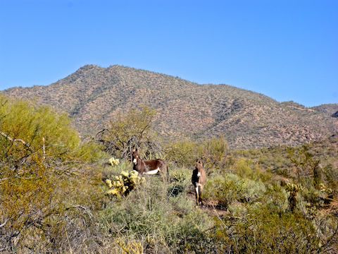
Hermit Trail turns northwest, heading up alongside a wash. If you hear a snort, that is a wild burro, which are not dangerous. Usually, they wander away before you can get a photo. A mile, and 400 ft. of AEG (accumulated elevation gain) from the sign-in, Hermit Trail reaches the first saddle. Ahead is the red, wedge-shaped, Hill 2992. (Which is not the summit of Governors Peak.) 🐴
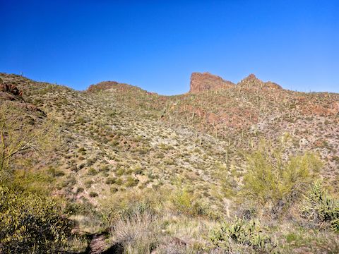
Hermit Trail then descends 50 ft., crosses a wash, and switchbacks up 370 ft. in only a ½ mile to the second saddle. Ahead, across Four Tanks Canyon, is the expanse of the Governors Peak ridgeline. Hill 2992 is just to the right, across the saguaro-studded canyon. Though Hermit Trail apparently ends at the second saddle, THE trail continues.
Though continuous tread, the trail descending 160 ft. from the second saddle to the bottom of Four Tanks Canyon is Bell Trail. Where Bell Trail goes from the bottom of the canyon — up canyon, down canyon to Castle Creek, or up to Governors Peak, I have no idea. 🤔
From the first saddle to the bottom of Four Tanks Canyon there were a lot fewer cairns. From the bottom of the canyon to the third saddle, the next cairn is always visible from whatever cairn you are standing next to. So, even in spots where the trail might not be obvious, the route you should take is.
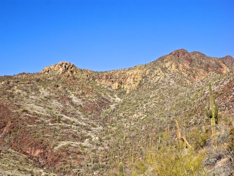
The trail — Bell Trail? — follows the plentiful cairns up a steep wash between Hill 2992, on the right, and the now visible summit of Governors Peak, on your left. It is 390 ft. in 0.4 miles to the third saddle, with some boulder steps and marble-covered slick rock to be negotiated. The saddle is marked by a large cairn. A trail begins to descend north, towards the Castle Hot Springs Resort, but you should turn left.
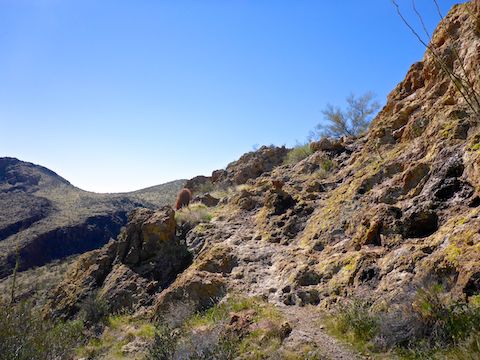
The trail climbs 450 ft. in the final 0.4 miles, first along the yellow cliff band, then most steeply up an easy chute, before crossing a grassy slope towards the hidden Governors Peak summit. The only flowers I remember — one ocotillo, and a cluster of pinkish-purple redstem stork’s bill — were on this segment. The trail splits at a point marked on the attached GPS route (below): Head left towards the pink surveyor’s tape, not right towards the cairn. 🎀
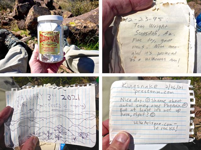
For some reason, the sign marking the Governors Peak summit is facing away from the trail. The summit log was a jumble of loose papers. The oldest I found was from December, 1995. As I was perusing the entries, I was surprised by a young gal approaching the summit. I didn’t want to weird her out, so I ate lunch on the side of the summit opposite Lake Pleasant, while she enjoyed the better views.
On the way back down to Four Tanks Canyon, I almost fell several times slipping on the marbles. The 160 ft. climb back up to Hermit Trail was more tiring than the 1600 ft. of AEG heading up Governors Peak. The only shade I found all day was provided by a fat saguaro 200 yds. before the Spring Valley Trail split, so I took another short break.
I finished my Governors Peak hike accompanied by the sound of gunfire, thankfully not aimed in my general direction. 🔫
Directions: From the Black Canyon Freeway / I-17, head west on the Carefree Highway / AZ-74. In 11.5 miles, turn right onto Castle Hot Springs Rd. In 5.5 miles, turn left to stay on Castle Hot Springs Rd., which turns into car-drivable dirt. In 1.5 miles, split right to stay on Castle Hot Springs Rd., which crosses the Garfias Wash bridge. The final mile is driving in Castle Creek, but it is hard-packed and still okay for cars. Park on the left as soon as you cross the cattle gate.
GPS File: Governors_Peak
Distance: 6.09 mi.
AEG: 1,854 ft.
Time: 3h 20m
Hiking Video
Hiking Governors Peak, Hells Canyon Wilderness from Preston McMurry on Vimeo.