

Hiking from the “top” end of the Boy Scout Loop to Table Mesa Rd. is the third segment, south-to-north, of the Black Canyon Trail. The BCT is a National Recreation Trail that stretches 80 miles from Carefree Highway, in far north Phoenix, to Russian Well, in Brushy Wash, near Orme School in Yavapai County.
There are several ways to hike the third segment of the Black Canyon Trail:
- New River Rd. to Table Mesa Rd.: South-to-north is 11.2 miles, 1200 accumulated elevation gain (AEG). The opposite direction would be 950 AEG. If you feel like Super Man, and want to do the long out & back, park at Emory Henderson Trailhead, as it at least has proper toilet facilities. Otherwise, do a shuttle hike or key exchange.
- Table Mesa Rd. to Boy Scout Loop: An out & back from Table Mesa Rd. to the north end of Boy Scout Loop is 11.8 miles, 1300 AEG.
- Gasline Rd. to Table Mesa Rd.: South-to-north, a one way shuttle hike is 8.2 miles, 800 AEG. This is the option I chose, hiking the same route I did in 2011.
There is no place to park at the north end of the Boy Scout Loop, not unless you have an OHV. And if you do have an OHV, and start from the north end of Boy Scout Loop, it just ends up being option #2, the opposite direction, and with a longer drive to your start point. Directions to the Gasline Rd. trailhead are below. 👇
Driving out of Phoenix at 7:00 a.m., I continued to be amazed at how little traffic there was. Granted, we were heading the opposite direction of “rush hour” — a relative term during the Kung Flu — but I estimate traffic was about ⅓ of normal. (I accumulated less than four minutes of dashcam material in March.) I started hiking just before 8:00 a.m.
I started hiking northwest, along Gasline Rd. In 300 yds., it crosses El Paso Gas Pipeline Rd. Keep going straight, northwest. At 0.6 miles, there is a turnaround, which used to be littered with shooting garbage. There was still some shell casings, but obviously someone had cleaned it up since 2011.
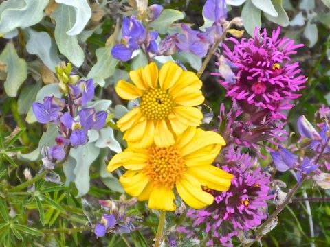
After the turnaround, the jeep trail descends to the Black Canyon Trail, which I followed north. There were Coulter’s lupine in abundance.
At the base of the Boy Scout Loop, I split left, clockwise, so I wouldn’t repeat the same bit of trail, the same direction, as I did back in February. I made it to the old wooden map sign at the north end of Boy Scout Loop in only 55 minutes. Though the temps were below normal, I was already sweating pretty good due to high humidity. 😅
The first of only two sort of climbs on this hike is from where Gasline Rd. intersects the Black Canyon Trail to the north end of Boy Scout Loop, about 400 ft. in a leisurely 1.7 miles. At the top of that climb is where the owl clover kicked off in earnest.
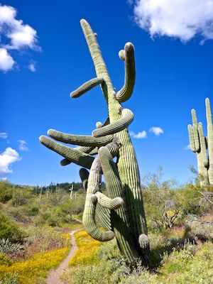
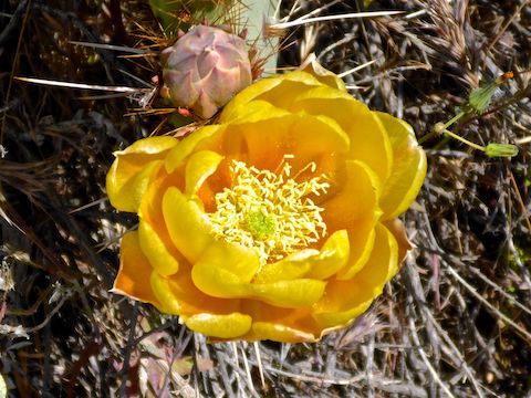
The third segment of the Black Canyon Trail only crosses one major wash. Entering and exiting the wash is all on trail, with no steep eroded sides. Normally, that would not merit a mention, but I bring it up as absent Spring flowers, the highlight of this segment is the saguaro forest that calls the wash home.
After crossing the wash, I started to see more flat top buckwheat, a plant with bushy bundles of small white flowers with pink highlights. (There’s a good flat top buckwheat photo from last week’s hike in Cave Creek Regional Park.) There were also a lot of fairy duster, but unfortunately none that really struck me as photogenic.
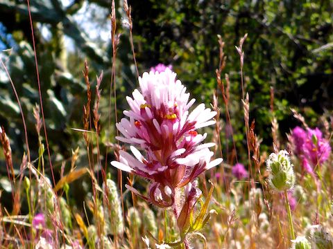
Strawberry hedgehog, aka Engelmann’s Cactus, still had bright pink flowers. (Despite supposedly blooming only five days a year, I’ve been seeing strawberry hedgehog blooms for several weeks now.)
4.7 miles into the hike, or 2.4 miles from the top of Boy Scout Loop, Black Canyon Trail crosses a half decent jeep trail. Heading southwest, the jeep trail becomes 500 Kv Power Rd., travelling under the high tension power lines towards Lake Pleasant. Heading east, the jeep trail crosses El Paso Gas Pipeline Rd. before ending two miles later at the Table Mesa Rd. onramp to southbound I-17. If you wanted to hike an out & back from the middle of the BCT’s third segment, this is where you would start. No idea if it is SUV-able. 🤔
It is also near that jeep trail that you may start hearing guns. There is at least one official, and a number of unofficial, ranges along Table Mesa Rd., which is almost two miles away. No worries: There are plenty of hills in between you and the pew pews. 👍
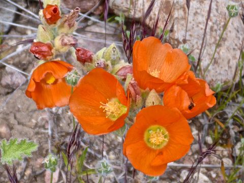
The second, and last, sort of climb on the Black Canyon Trail’s third segment is 150 ft. in ¾ of a mile, from the jeep trail north to a saddle overlooking the power lines. I had occasionally seen desert globemallow earlier, but descending off that saddle was there were just scads of them. I took advantage of a cloud passing over to pop some against the cloud’s shadow with a flash. Check out the video, below. 📸
The owl clover somehow got even better between the saddle and the power line!
There’s a second jeep trail, Old Mine Rd., 6.8 miles into the hike, or 4.5 miles north of Boy Scout Loop. Following the Black Canyon Trail is a bit confusing here: Turn left onto Old Mine Rd. for about 200 ft., turning right back onto the BCT just after crossing a small wash.
The powerlines pass over the Black Canyon Trail a ¼ mile north of Old Mine Rd. It’s only one more mile to Table Mesa Rd.
When I hiked the BCT’s third segment nine years ago, much of the final ½ mile was littered with brass and shot up junk, like old TVs, propane tanks, bottles, etc. I might have seen a casing or two, but it has been significantly cleaned since 2011. Thankfully, shooters have since been using the more formal ranges along Table Mesa Rd.
This time around my wife was waiting for me at the correct place, where the Black Canyon Trail crosses Table Mesa Rd. I was done at exactly noon, and after stopping at Culver’s along the way, home by 1:00 p.m. I like those kinds of hikes! 😁
Gasline Rd. TH Directions: From Phoenix, head north on I-17 to Exit 232, west onto New River Rd. After passing under I-17, take the first right onto dirt 43rd Ave. There may be a “No Trespassing” sign: It is legal to ignore it. In 200 yds., the road splits. There may be a second “No Trespassing” sign: That one you do not want to cross. Instead, split left onto Gasline Rd., which is bumpy dirt. Drive as far as you are comfortable, then park anywhere. I went ⅓ mile in an SUV.
Table Mesa Rd. TH Directions: Heading north on I-17, take Exit 236, west onto Table Mesa Rd. After passing over I-17, take the first right. Table Mesa Rd. becomes smooth dirt road. You will pass a number of firing ranges and OHV trailheads. The Black Canyon Trail trailhead is at 3.0 miles, on the right side of Table Mesa Rd.
GPS File: BCT_Boy_Scout_Loop_to_Table_Mesa_Rd
Distance: 8.71 mi.
AEG: 1,064 ft.
Time: 3h 17m
Hike Video
Black Canyon Trail: Boy Scout Loop to Table Mesa Rd. from Preston McMurry on Vimeo.