
.")
Lots of folks frequently hike Phoenix’s South Mountain Park. Even though South Mountain has 100 miles of dirt trails spread over 16,283 acres, I prefer to roam around. Not burn a place out. So, once a year is good enough for me. (Or twice, when I was doing my Loop 202 South Mountain freeway survey hikes.)
I beat rush hour to south Phoenix, hitting up the new Einstein Bros. Bagels at 32nd St. & Baseline Rd. for breakfast, waiting for sunrise. Driving up Telegraph Pass Rd. in South Mountain Park, the sun was just above the horizon of the pass. I couldn’t see for the glare. Prayed no one drove over the line towards me. To make matters worse, I had an arch cramp in my right (gas pedal) foot. Argh! Agony. 😫
I got out of my SUV at Dobbins Lookout. Though 52℉, it felt cold due to the wind. I can’t imagine how bad the pit toilet would smell in hot weather. As it was, it smelled like a dead cholo was in there. Back in my SUV, I tweeted while waiting for the temps to gain a few degrees. I finally started hiking at 9:15 a.m.
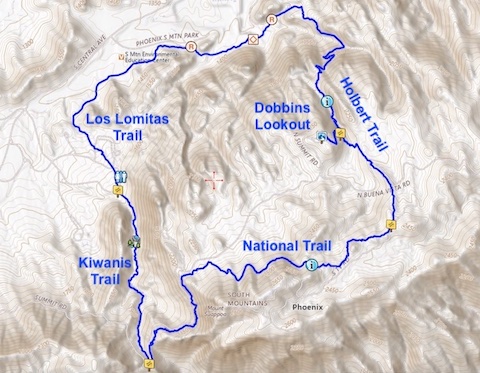
I made a slight wrong turn, but soon turned up Holbert Trail. Each trail is color-coded: Holbert Trail is navy blue, National Trail is dark brown, Kiwanis Trail is purple, Los Lomitas Trail is light brown, and Dobbins Lookout is orange — all marked by stickers on square metal posts, at trail intersections.
Holbert Trail is 2.5 mi., 1,250 ft. AEG (accumulated elevation gain), from the Holbert Trailhead, at the bottom, to TV Road, near the Mount Suppoa antenna farm. Dobbins Lookout is about ¾s up Holbert Trail. Most folks hike the Holbert Trailhead – Dobbins Lookout round trip, which is 4.1 mi., 1,000 ft. AEG. I hiked that … geez … 17 years ago? Wasn’t even hike blogging back then.
National Trail is the backbone of South Mountain Park. From the San Juan Lookout, east to the Pima Canyon Trailhead, National Trail is 14.5 mi., 2,360 ft. AEG. I’ve hiked parts of National Trail more times than I can count. Other than Fat Man’s Pass / Hidden Valley, my favorite part is the quarter mile between Holbert Trail and Mount Suppoa.
Today’s National Trail segment was 2.2 mi., rolling for the first mile. Make sure you sign the “summit” log! National Trail then drops towards Telegraph Pass, often in late-morning shadow on the north slope of Mount Suppoa. The final three-quarters of a mile are just 50 ft. from Telegraph Pass Rd. Traffic was picking up at 10:30 a.m. Some of it speeding over the double yellow line. 🤨
Kiwanis Trail has a unique sign, with cut out & painted letters. Kind of fancy. Wonder who paid extra for that? Anyway, on the south side of Telegraph Pass Rd. is a standard trail sticker post. Careful crossing the road. Kiwanis Trail was my other favorite part of my hike. As I hiked it, it drops 400 ft. in a mile, through a relatively lush canyon. There’s a stone check dam, a quarter mile from the bottom.
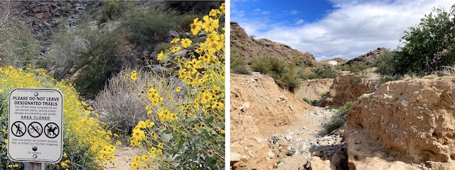
Desert flower coverage was decent despite the cool weather. Brittlebush were most common, particularly along Kiwanis Trail. Next most common was Emory’s rock daisy. Coulter’s lupine below Mount Suppoa. Desert globemallow here & there. Mexican gold poppy mostly closed up due to chill. Plus blue dick, distant phacelia, and a single desert marigold.
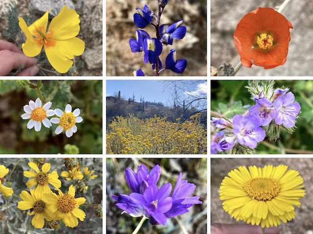
Top Row: Mexican gold poppy, Coulter’s lupine, desert globemallow.
Middle Row: Emory’s rock daisy, stinknet, distant phacelia.
Bottom Row: brittlebush, blue dick, desert marigold.
Los Lomitas Trail drops 240 ft., over 1.3 miles, as it winds through picnic areas, and past parking lots, in South Mountain Park’s apparently unnamed central valley. Whereas Holbert Trail, National Trail and Kiwanis Trail are solely singletrack, Los Lomitas Trail is mostly wide & smooth, and oldster friendly. Los Lomitas Trail hugs the bottom of Guadalupe Ridge, so it has some photogenic boulders.
If you hear shooting, no worries: It’s the police range. 👮🏻♂️
Just east of the South Mountain Park visitor center, the Holbert Trailhead is a big constuction zone, and will remain so through late 2027. Los Lomitas trail follows the construction fence east.
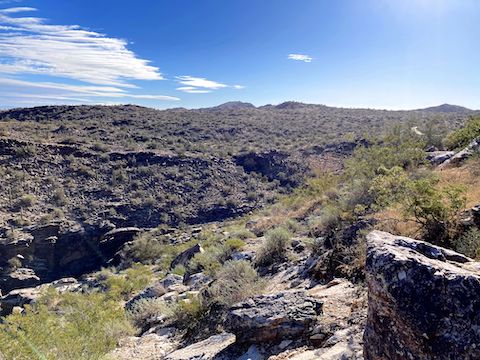
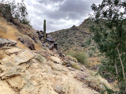
Holbert Trail’s washout is easy to negotiate. It sure is no Bear Canyon. Keep an eye out for petroglyphs in the area. After crossing the washout, the singletrack briefly joins the road, also called Holbert Trail, that accesses the municipal elevated water storage tank pictured above. Just before the tank, Holbert Trail turns back to dirt at a red-sticker that warns it is closed during extreme heat warning days.
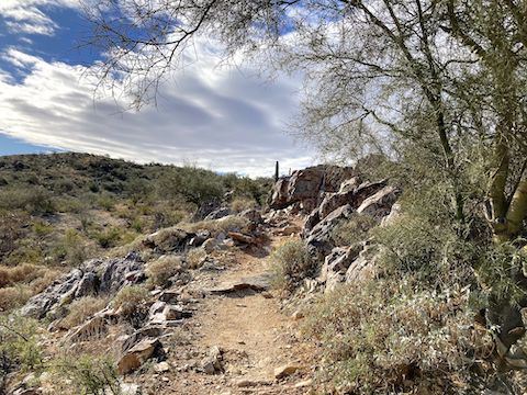
I needn’t worry. It was getting cloudy, and I could spot rain falling across Phoenix. After a quick 13% climb, Holbert Trail “levels out” to 10% slope for a half mile as it swaps canyon sides. From there, Holbert Trail is a consistent 13% slope the final mile back to Dobbins Lookout. I didn’t remember Holbert Trail being this steep on my long ago hike. Maybe it is age? I took my time.
Dobbins Lookout Directions: From I-17 in south Phoenix, take exit 195B, south onto 7th St. In 3.5 miles, turn right on Baseline Rd. In 0.5 miles, turn left on Central Ave., which enters South Mountain Park in 1.5 miles. Mind the 25 mph speed limit: It’s twisty, and there’s bicycles. At the San Juan Bike Hub, bend left onto Telegraph Pass Rd. (Right is San Juan Rd., which is usually closed to motor vehicles.) Note the mileage markers. Telegraph Pass is at mile marker 3.5. Just past mile marker 5.0, split left towards Dobbins Lookout, which is in a quarter mile.
Park Map: South_Mountain_Park_Trail_Map (pdf)
GPS File: South Mountain_Holbert_National_Kiwanis_Los Lomitas
Distance: 7.95 mi.
AEG: 1,475 ft.
Time: 3h 26m
Rumble Video
Vimeo Video
Hiking South Mountain Park, Phoenix from Preston McMurry on Vimeo.