

This is my third Valley of the Sun local parks hike of the winter, after hiking Estrella Mountain Regional Park two weeks ago.
Skyline Regional Park, Maricopa County’s newest, is in Buckeye, three miles north of I-10, in the southern foothills of the White Tank Mountains. Skyline is 8,700 acres with 16 miles of trails for hiking, biking & horseback riding. (More are being added all the time.) There is even a wheelchair accessible trail. ♿️
Like Estrella, Skyline Regional Park has picnic gazebos and camping areas. There is a gate, but currently no entrance fee.
To (mostly) avoid the hell that is I-10, I drove an extra 30 miles to get to Skyline. First, I headed north out of Phoenix to I-303. I took that around the northwest corner of Phoenix to the far west end of Bell Rd., in Surprise. There’s a lot less traffic on I-303 than I-101. (Taking the 303 also avoided the hell that is Bell Rd. through Sun City.) Heading west, Bell Rd. turns into Sun Valley Parkway, which loops around the west side of the White Tanks. Sun Valley Parkway is four separated lanes, mostly 55 mph. Doing the speed limit, I was passed by a school bus. 🙄
On the way into Skyline Regional Park, on Watson Rd., I passed a cluster of cop cars off to the side. Good thing I was still doing the speed limit. (When I left, four hours later, they were still there: I wonder what was going on?)
There were quite a few cars in the Skyline parking lot, but nowhere near as many as you find in the Piestewa Peak lots. I hit the trail at 8:35 a.m.
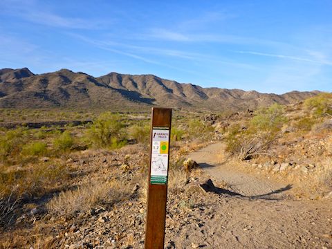
I crossed a fairly significant pedestrian / bike bridge, across a deep wash. On the north side is the wheelchair accessible Red Tailed Hawk Trail, which I started down until realizing I should be seeing dirt. Correcting myself, I headed west for a ¼ mile on the Mountain Wash Trail. There, I began my loop.
I planned to hike the “big loop” clockwise around Skyline Regional Park, doing all of Chuckwalla Trail, Valley Vista Trail, Skyline Crest Trail and Crest Summit Trail, plus bits of Turnbuckle Trail, Granite Wash Trail, and Quartz Mine Trail back to the trailhead. Overall, I expected it would be about 10 miles and 1800 AEG.
Turnbuckle Trail was so wide & well-groomed Sonja Henie could have skated on it. If it was 50° colder. And Phoenix actually got some moisture that could be turned into ice. In any case, most of the pedestrian traffic seemed to be heading up Turnbuckle towards the Valley Vista Trail saddle.
Granite Falls Trail was not quite as wide or well groomed as Turnbuckle, but it was still no look walking, except when crossing washes. The lack of ankle breakers makes the whole Skyline trail system ideal for trail runners, though I did not see any people off of Turnbuckle.
Chuckwalla Trail, which swings out wide to the west, is similar to Granite Falls, but with fewer wash crossings. Both Chuckwalla and Granite Falls do, however, cross many jeep trails. Skyline Regional Park has trail signs every ¼ mile: It is near impossible to get lost. If you hike for more than five minutes without seeing a trail sign, head back to where you made your last turn. Chuckwalla climbs 200 ft. — man the defibrillator! — in 1.25 miles to Indian School Rd. I’m serious. That’s what it is, even though it looks like just another old jeep trail. From Indian School Rd., Chuckwalla turns back east, for a mile, until it connects back to the north end of Granite Falls.
It was on Chuckwalla Trail that I realized Skyline Regional Park had no flowers (yet anyway). There were mountains, and hills, but no interesting rock formations. There was one jeep trail into a wash that looked like it would be fun to ramp on a mountain bike, but I never saw a single MTB all day, not even in the parking lot. Nor did I see any horses. (Though I did see tracks for both.) In other words, there really wasn’t much to photograph other than saguaro. So, that is what I did.
After a few minutes Granite Falls connects back to Turnbuckle. From that intersection to the Valley Vista Trail summit, is a 700 ft. climb in about a mile. However, Turnbuckle — or Turn-BACK-le as I kept malapropping it in the hike video 🤪 — has a jillion switchbacks, so while a good blow, it is not too steep.
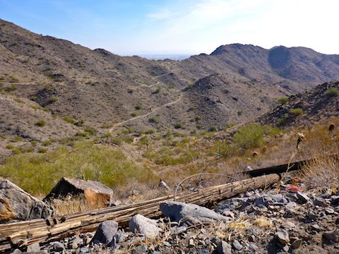
Valley Vista Trail is the rockiest, narrowest, trail I hiked on in Skyline, but no worse than going up the south side of Shaw Butte. There is another guide post at the summit, but I went about 100 yds. past that. It requires some very minor scrambling, but is level, and leads to a much more panoramic view of Skyline Regional Park and points south. Unfortunately, the distant view was obscured by awful smog along the I-10 corridor. It was so bad, I could barely make out the Estrella Mountains, only 10 miles away. I could see Luke Air Force Base to the east. Several pairs of F-16s blasted overhead during my hike, but I could never deploy my camera fast enough to get decent video of them. 😕
While taking a break at the Valley Vista lookout, I dropped my camera. 😣 Then the battery on my crappy Garmin 62S nearly died. 😕 My backup batteries were dead. 😡 I cut my break short, put the 1-bar batteries back in the GPS, then hauled ass back down Valley Vista Trail. Rather than continue my loop to Skyline Crest Trail, I bailed down Turnbuckle towards the trailhead. I was a quarter mile away when the 1-bar GPS batteries went kaput. I got to my car and couldn’t find my phone. 😱 Panic set in. Fuck, I thought I would have to back track two miles and 900 AEG — one way — to the lookout, and hope my phone had not grown legs. 🙏🏻 After much 🤬, I found my phone in the bottom of my pack. 😍 Hiking! 😉
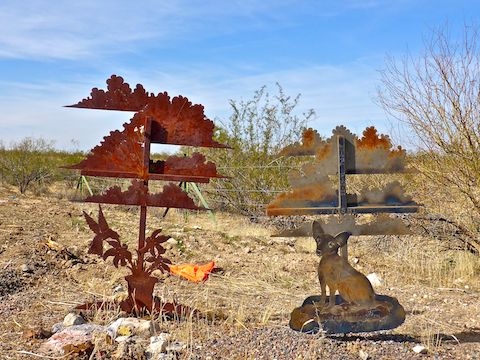
It was about Noon, and I finished a few hours earlier than expected, so I picked up lunch at the first place I saw at the I-10 interchange — Carl’s Jr. — then headed back up Sun Valley Parkway doing some roadside memorial hunting along the way. Unfortunately, I only found one. Well, fortunate for whoever might have otherwise been memorialized. 😇
To summarize, Skyline Regional Park is not a destination hike, but it is a good place to get exercise.
Directions: From Phoenix, head west on I-10. Take Exit 117 onto north Watson Rd. Drive 2.0 miles to the no fee gate, then another 0.9 miles to the end of the road.
GPS File: GraniteFalls_Chuckwalla_ValleyVista_Turnbuckle
Distance: 7.39 mi.
AEG: 1,239 ft.
Time: 2h 50m