

Lot of stuff going on behind the scenes are Kingsnake Studios. I’ve been uber busy. Not sure where to look for #flowerporn this week, and not having been to Skyline Regional Park in over a year, I decided schlep back out to Buckeye.
The last time I was at Skyline, I hiked several of the trails west of the trailhead: Turnbuckle Trail, Granite Falls Trail, Chuckwalla Trail and Valley Vista Trail.
This time I headed east, hiking Mountain Wash Trail, Lost Creek Trail, Skyline Crest Trail and Quartz Mine Trail. In case flowers were thin in the White Tank Mountains, I added the Verrado Petroglyphs to my route, so I could guarantee some interesting photos. I also added the Crest Summit Trail, hoping for extra elevation gain and some nice views. 📷
Rather than take I-303 and the Sun Valley Parkway, like I did in 2018, I decided to take I-303 all the way down to I-10, mostly avoiding the hell that is that I-10 closer to Phoenix. (I can still remember I-10 ending in Buckeye, and having to drive Buckeye Road into central Phoenix, or take Dysart Road north, past miles of vegetable farms to north Phoenix.)
While getting ready at the Skyline Regional Park trailhead, I saw what I thought was a poo pumper truck. Not quite.
As I passed by the restrooms — actual running water & flush toilets! — I saw the truck, next to which was a guy in a wetsuit & silver dive helmet, with hoses coming out of it. I thought maybe they were filming a commercial, but instead the diver climbed into a tiny pipe & disappeared!
I found out later that the diver was clearing blockages in the water / sewer line. 💩
Mountain Wash Trail starts just over the bridge from the trailhead. Officially 1.06 miles, Mountain Wash Trail connects at both ends to Turnbuckle Trail. It is wide & mostly smooth, and crosses the unnamed sandy wash three times. It is rated moderate. (Official trail difficulty ratings are scaled to day walkers, not strong hikers, as evidenced by the “double black diamond hazardous” rated Ford Canyon Trail.) 🤨
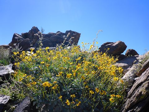
Skyline Regional Park was not in “super bloom”, but on Mountain Wash Trail I did spot what looked like a pink lupine, globe chamomile, brittlebush (of course), and Fremont’s pincushion — a white, difficult to photograph, flower that looked like a small carnation.
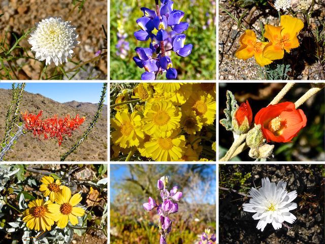
Middle Row: ocotillo, desert marigold, desert globemallow.
Bottom Row: brittlebush, ???, desert chicory.
I was only on Mountain Wash Trail for ¾ of a mile and 225 AEG, before splitting right onto Lost Creek Trail.
Lost Creek Trail, an old jeep trail, is measured at 1.03 miles long, between Mountain Wash Trail and the eastern boundary of Skyline Regional Park. (Note that the old jeep trail continues another 1.2 miles to the Verrado Trailhead.) Rated moderate, it climbs 250 ft. in only a ⅓ of a mile to the intersection of Skyline Crest Trail, then drops 400 ft. in a half mile to the park boundary.
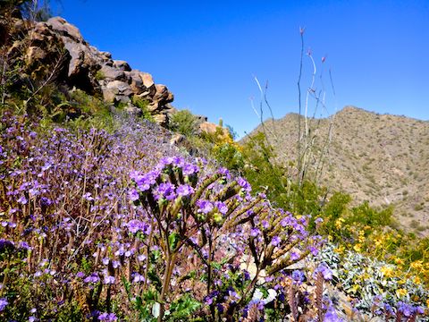
Flowers on Lost Creek Trail included California sun cup, scorpionweed, Mexican gold poppy, Fremont’s pincushion and scads of lupine. I even saw one lupine patch growing in the middle of the old jeep trail! 🤗
SOB Trail is a marked, but apparently unofficial, mountain bike trail along the eastern boundary of Skyline Regional Park. It switchbacks 225 ft. in a mile to a saddle on the west slope of Hill 1976. SOB Trail then follows the contour for a ½ mile to Hill 1976’s east slope, where there is a rocky foot trail that connects the Verrado Petroglyphs back to the old jeep trail. SOB Trail was a pleasant stroll.
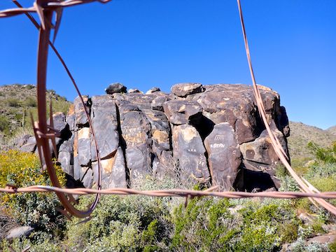
A razor wire-topped fence makes it difficult to photograph the Verrado Petroglyphs. Not only due to distance, with my crappy pocket camera, but also angle, as many of the etchings are high on the varnished rock formation.
I really don’t like rocky trails — they are hard on the feet, and there’s always the threat of breaking an ankle — but I followed it from the Verrado Petroglyphs 200 ft. down to the old jeep trail. In a ¼ mile, I was at the SOB Trail sign, back in Skyline Regional Park.
On the 400 ft. climb back up Lost Creek Trail, I was passed by a sheriff’s deputy in a weight vest. 😅
Skyline Crest Trail is 1.3 miles of single track, south from Lost Creek Trail to Quartz Mine Trail. The handful of steep little 50 ft. climbs on Skyline Crest do not come close to justifying its “difficult” rating. It’s mostly level, then downhill to Quartz Mine Trail. (Done the opposite direction, south to north, the climb is 250 ft. in a ⅓ of a mile, or the same as moderate rated Lost Creek Trail.)
I loved Skyline Crest Trail! It winds along the spine of the ridge, each twist revealing a new, awesome view: southwest towards the Eagletail Mountains, south to the Gila Bend Mountains, southeast to South Mountain, and east into Phoenix. ⛰
Though not reaching “super bloom” levels, there were scads of flowers on Skyline Crest Trail: desert tobacco, desert globemallow, scorpionweed, desert chicory, and the only decent ocotillo I spotted all day. (Most ocotillo blooms I saw were fading to brown.)
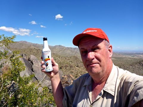
Crest Summit Trail is steep, but it is so short — only .17 miles — that I have a hard time believing that is why Skyline Crest Trail is rated difficult. It’s only a 200 ft. climb. At the top, I found a fairly smooth back supporting rock to recline against, and sat down for lunch and a hiking beer, while enjoying the spacious view.
Afterwards, I headed down Skyline Crest Trail, picking up Quartz Mine Trail at its mid-point, blasting through 1.4 miles to the trailhead in only 30 minutes. There may have been a few flowers on Quartz Mine Trail, but I had already got what I came for, and so wasn’t much interested in spending time looking. 😉
Directions: From Phoenix, head west on I-10. Take Exit 117 onto north Watson Rd. Drive 2.0 miles to the no fee gate, then another 0.9 miles to the end of the road.
GPS File: MountainWash_LostCreek_Verrado_SkylineCrest_QuartzMine
Distance: 8.47 mi.
AEG: 1,815 ft.
Time: 3h 30m