

The Prescott Circle Trail is a 54 mile, all dirt, loop around the city of Prescott.
I’ve been on bits and pieces of the PCT in the past, such as Ranch Trail #62, but I’ve never hiked the Prescott Circle Trail as concious objective.
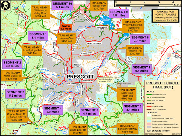
The map below breaks the PCT down into ten segments of 2.7 to 9.1 miles, each anchored at both ends by a trailhead on a major Prescott-area road. Today, my mine exploring buddy Paul & I hiked Prescott Circle Trail Segment #3, southwest of the city, from Copper Basin Rd. to Thumb Butte Rd. PCT Segment #3 is officially 5.5 miles long, but the nearest trailhead to where the PCT crossed Thumb Butte Rd. is a mile east at the Thumb Butte Recreation Area. 🏕
A one-way shuttle hike, or key exchange, north from Copper Basin Rd. to the Thumb Butte Recreation Area is 6.5 miles and a meager 400 AEG. Hiking Segment #3 south is increases the AEG to a breathtaking 1,000 AEG. An out & back, either way, is thus 13.0 miles and 1,400 AEG. Paul & I hiked only northbound, but chose instead to increase our mileage and AEG by first heading from Copper Basin Rd. up to Wolverton Mountain Trail #9415, then down Aspen Creek Trail #48 back to the Copper Basin Rd. trailhead, before heading out on Segment #3 proper.
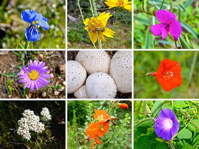
After the brief climb up to Wolverton Mountain Trail #9415, Paul & headed down Aspen Creek Trail #48. Good choice: We were immediately greeted by a large quantity and variety of flowers, a trend which would continue throughout the day. The species were mixed up with each other all along the Prescott Circle Trail: columbine, lupine, globemallow, Arizona thistle and many more. I’d guess at least 20 species, some too small for my cruddy pocket camera to photograph, even in macro mode. 🔎
Unfortunately, while crouching down to take my very first flower photograph, I ripped the crotch of my frequently patched hiking pants. This lead to much merriment on Paul’s part, cracking jokes as the hours wore on and the rip grew larger. It got so big — nearly down to my knee — that every time we encountered other people, I turned away as if photographing whatever flower happened to be near. It’s a good thing I was not going commando. 😳
When we arrived back at the Aspen Creek trailhead, my wife was gone, so I texted her to please go to Walmart and get me some shorts, any shorts, so that when Paul & I finished the hike I would have something to wear which would not earn me a record as a sex criminal. 👮🏻♂️
I continued hiking with the enhanced ventilation.
Luckily, we only saw two other hikers. Not so luckily, we were passed by at 30-40 mountain bikers. We saw a few every 10-15 minutes, including one MTB club ride of at least 20. 🚵♂️
I’m not sure about the other Prescott Circle Trail segments, but the one between Copper Basin Rd. and Thumb Butte Rd. is optimized for mountain bikes, with plenty of switchbacks, gentle grade, and few obstacles. A hiker, or experienced biker, will cruise right over the ‘rocky’ PCT sections.
Prescott Circle Trail Segment #3 consists of Cold Springs Trail #393, Potts Creek Trail #327, Circle Connection Trail #322 and Garden Grove Trail #392.
A mile and a half up Cold Springs Trail #393, near Camp Stein — the Prescott area is littered with summer camps — where the PCT transitions onto Potts Creek Trail #327, there is a logging operation. Other than the swish of MTB tires, it was the only unnatural sound we heard between Copper Basin Rd. and Thumb Butte Rd.
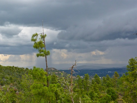
It was mostly sunny along the Prescott Circle Trail, but dark clouds were moving over the city itself.
Halfway up Potts Creek Trail #327, we got misdirected onto FR 51 for a half mile. My bad. I blame the distraction in my pants.
It would have been shorter to pop over to Circle Connection Trail #322, but we backtracked so I could generate an accurate track. Such a deal I give to you!
Trail #322 is short, maybe ¾s of a mile, but it has been slightly rerouted for trail reclamation. You can’t get lost. Unless you are me.
Trail #322 transitions to Garden Grove Trail #392 where the Prescott Circle Trail intersects Thumb Butte Bypass Trail #326. All the intersections are signed.) By the time Paul & I got to Trail #392, it was raining over Prescott. We didn’t even get drizzle, but thunder caused by rather close lightning strikes twice made me jump. ⚡️
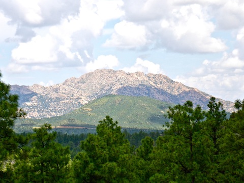
The dark clouds came, and went, and came back again. We got one cloud break ⅓ of a mile onto Trail #392, giving us a great of view of Granite Mountain looming behind Little Granite Mountain, both of which we’ve hiked together.
Once we reached Thumb Butte Rd. we turned east along what I believe is an unnumbered trail that parallels the south side of the road. A ⅓ of a mile before the Thumb Butte Recreation Area, there is an old stone well. There is a spring next to it, but the well itself is now dry and full of dirt.
I made it most of the way across the campground without anyone noticing the gaping hole in the front of my pants. Unfortunately, there was a forest crew enjoying a break right next to where my wife was waiting for Paul & I. The shorts she bought were a bit small, but like I told her, by that point I would have worn a dress. 👗
Postscript: Today marked my 144th hike of 2018, breaking a personal best I set just last year. 👍
Directions: From Courthouse Square in Prescott to the Copper Basin Rd. trailhead, head south on US-89 for 0.9 miles. Turn right on Copper Basin Rd. In 4.6 miles, just past Aspen Creek Spring, turn right into the trailhead. The last 1.5 miles are car drivable dirt. From Courthouse Square to the Thumb Butte Recreation Area, head west on Gurley St. for 3.5 miles. (Gurley St. becomes Thumb Butte Rd.) At the foot of Thumb Butte, turn right into the trailhead.
GPS File: Prescott_Circle_Trail_Segment_3
Distance: 9.42 miles
AEG: 655 ft.
Time: 3h 37m
Hiking Video
Prescott Circle Trail: Copper Basin Rd. to Thumb Butte from Preston McMurry on Vimeo.
Arizona does have green spots! The flowers are wonderful and so are the flowers.