
. Cauliflower mushroom are apparently quite tasty, but I did not eat that massive unit with my hiking beer.")
Quaking Aspen Canyon is located on the Mogollon Rim, just six miles east of AZ-260. Kehl Ridge is on its right flank, while Cienega Draw and Potato Lake Draw feed into it from the west. Poverty Flat is at Quaking Aspen Canyon’s north end. After 4½ miles, just past Poverty Flat, Quaking Aspen Canyon becomes East Clear Creek.
There are several other nearby draws and creeks that feed into East Clear Creek. Today’s objective was to hike from the intersection of FR 308 and FR 308C, down one unnamed feeder, for about three miles, turn west towards Poverty Flat, then follow the bottom of Quaking Aspen Canyon back to FR 308C. 🧭
There’s a ton of forest roads between and around the unnamed East Clear Creek feeder draw and Quaking Aspen Canyon. Other than FR 308 and FR 147, I believe they are all decommissioned. At least the ones I hiked on were.
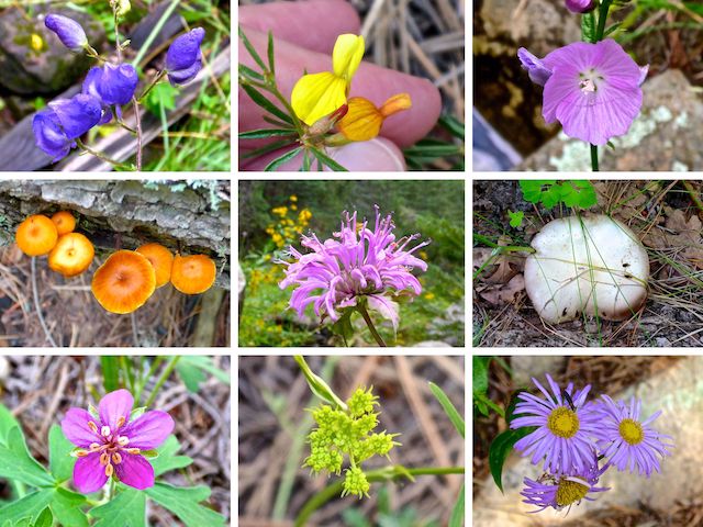
Top Row: Columbia monkshood, red and yellow pea, New Mexico checkermallow.
Middle Row: unknown mushroom, wild bergamot, unknown mushroom.
Bottom Row: pineywoods geranium, alpine false springparsley, alpine leafybract aster.
Hoping to beat lunchtime thunderstorms, so I started hiking at 8:30 a.m. Splitting the difference between FR 308 and FR 308C, I aimed for the low ground. It may not be immediately obvious, but head straight north, and in about 100 yds. the ground will start folding. Stay low.
Continue to follow the low ground for the next three miles to the large metal pipe which marks the junction with East Clear Creek. When canyon crawling, I avoid roads, otherwise what is the point? But after 10 minutes, I picked up FR 308H, which was the low ground in several stretches. For the next 1½ miles, I alternated between the road and 25-50 ft. off to its side, depending on where the flowers were — and there were a lot! 🤗
After 1½ miles, the low point crossed FR 308, which turns north-northwest at West Kehl Canyon, heading towards FR 147 at Poverty Flat. The crossing would be a good place for casual hikers to loop back to the trailhead on FR 308C. Why?
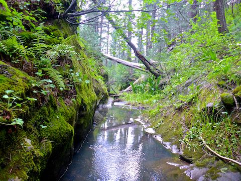
Though there were no major obstacles in the ECC feeder canyon, like Hi Fuller Canyon, nor ungodly tangles of deadfall like Crackerbox Canyon. But travel was slower going than most of my Mogollon Rim canyon crawls. And, as you can see above, it got quite narrow. I kept my feet dry for awhile, but the point of canyon crawling is to stay low, not mid-slope, so I gave up and just sloshed down the now audibly flowing creek.
The East Clear Creek feeder canyon never gets more than 100 ft. deep. Usually it is only 60 ft. up to FR 308 or FR 308G. However, I was expecting the road to at least be in sight, but there are several points where there are actually small cliffs, rather than bailable slope. 🏞
Not just terrain, but photography slowed me down. I ended up shooting over 300 photos. Because low & close makes for more interesting photos, that is a lot of up & down.
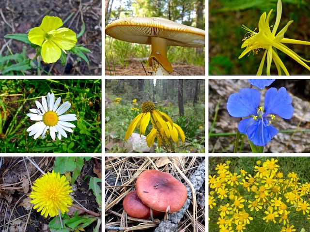
Top Row: silky evening primrose, unknown mushroom, yellow columbine.
Middle Row: oxeye daisy, coneflower, western dayflower.
Bottom Row: dandelion, unknown mushroom, Richardson’s bitterweed.
When I reached East Clear Creek proper, I found a 4-way intersection: Straight ahead, down ECC. Right, another unnamed side canyon. Back, the way I came. Left, up ECC to Poverty Flat. I turned left. It was easy travel for about 200 yds, but then I encountered the most tangled part my hike: boulders, pools and choking vegetation. I literally canyon crawled.
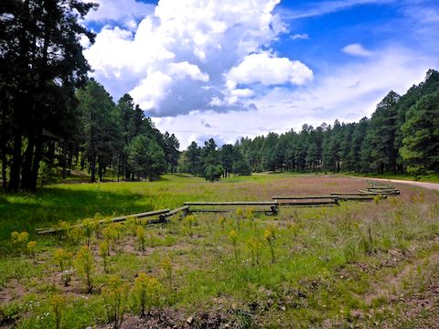
By the time I reached a gateless barbed wire fence 3¼ miles into my hike, I had had enough. For the next 2½ miles to Cienega Draw, I either hiked across grassy Poverty Flat, or actually on FR 147. 😅
The widest variety, and greatest density of flowers, I’ve found on the Mogollon Rim was between the trailhead and Poverty Flat. What I believe were oxeye daisy (Leucanthemum vulgare) were most common. Tons of coneflower (Rudbeckia laciniata) for ⅔ mile above the pipe. Fair number of common self heal (Prunella vulgaris), which I recognized as some sort of pea flower, but had not seen before.
Another first-time flower sighting was silky evening primrose. The scientific name is Oenothera pubescens, which sounds like “wine pubes”. I’d only seen red cinquefoil (Potentilla thurberii) once before, in Middle Miller Canyon, but today I found one or two of them in a half dozen locations. Species I did not photograph included pygmy bluet, woolly mullein, scarlet penstemon and lupine.
After 5¾ miles, I realized FR 147 was bending away from my trailhead, so I dropped into Quaking Aspen Canyon at Cienega Draw. The low point wasn’t bad, but looking ahead it looked like it might be closing up, so I bailed 50 ft. up to FR 308K. At 6⅔ miles, I split left onto FR 6108, where the Quaking Aspen Canyon was now a slight crease like I started on. 😏
Less than a ¼ mile later, I split left again, onto FR 308M. Like the other lettered forest roads, it was decommissioned. Really, really decommissioned. In another ¼ mile, I gave up trying to follow FR 308M climbing up through the vegetation to FR 308, which I followed ⅔ mile back to my FR 308C trailhead.
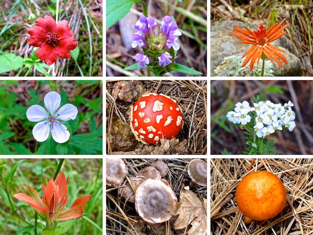
Top Row: red cinquefoil, common self heal, Mexican silene.
Middle Row: Richardson’s geranium, fly agaric, western yarrow.
Bottom Row: paintbrush, unknown mushroom, unknown mushroom.
Directions: From Phoenix, head north on AZ-87, the Beeline Highway, through Payson, Pine and Strawberry. (Alternately, take I-17 north, then AZ-260 east.) 2.6 miles north of AZ-260, turn right onto Rim Rd. / FR 300. There’s logging going on around Baker Butte, which has actually improved the road surface. In 5.6 miles, turn left on FR 308. In one mile, park on the left, in the FR 308C triangle.
GPS File: East_Clear_Creek_Quaking_Aspen_Loop
Distance: 9.28 miles
AEG: 600 ft.
Time: 3h 54m
Hiking Video
Hiking East Clear Creek & Quaking Aspen Canyon from Preston McMurry on Vimeo.