

I may ‘only’ be 56, but I need to up my game if I ever hope to accomplish my goal of hiking all the named Mogollon Rim canyons between AZ-87 and AZ-260 before I croak. There’s a lot of them.
Hi Fuller Canyon is flanked by Crackerbox Canyon, to its east, and East Miller Canyon, to its west. Of course.
Hi Fuller Canyon flows into East Miller Canyon at the tip of Valley Ridge. FR 501A runs along the crest of Valley Ridge. I have no idea who Hi Fuller was: Google, it no help. 😒
Hi Fuller Canyon is only two miles long, which means minimal ROI on the 5 hour, round trip, drive from Phoenix. Because it is so short, after hiking down to East Miller Canyon, I planned to backtrack a bit on Hi Fuller, before taking an unnamed drainage back up, then complete the ~5 mile loop on FR 501A. Even if I had to canyon crawl the whole way, it wouldn’t be far.
I figured since I will be doing two 8+ mile hikes in Flagstaff before the end of September, I would have no problem making my 50 miles for the month, so I could fit in Hi Fuller Canyon. If I were you, though, I would not hike it unless I was camping in the area.
The 11 mile drive in on Rim Rd. was even bumpier and more rutted than normal. The summer monsoon really did a number on it. 🚫🚘
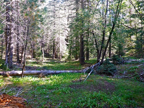
I hiked north on FR 501A for a few hundred yards, before turning right into upper Hi Fuller Canyon. It starts wide, shallow, and mellow. There was a fair amount of deadfall, but all of it either easily avoided or stepped over.
There were a few flowers in Hi Fuller Canyon, but they were small and scattered. It was immediately obvious the #flowerporn had turned Rated G for the Fall. 😕
A mile north into the canyon, it dawned on me that I was not just hiking in Hi Fuller’s drainage, or on a shelf, but that I was in fact on a very old jeep trail. I could see the twin tracks, even though they were overgrown with grass. I could see one end of the jeep trail heading up hill. According to the topo, it connects to FR 501 between Tracy Lynn Tank and FR 501B.
There were two intermittent tanks, both dry, just south of Hi Fuller Spring. Oddly, the spring is downslope from the tanks. The ground in the spring area varied from moist to wet, but I never did find the spring source itself.
The jeep trail I had been on crossed the dry tank closest to the spring, then turned southwest, up Valley Ridge where it must connect with FR 501A.
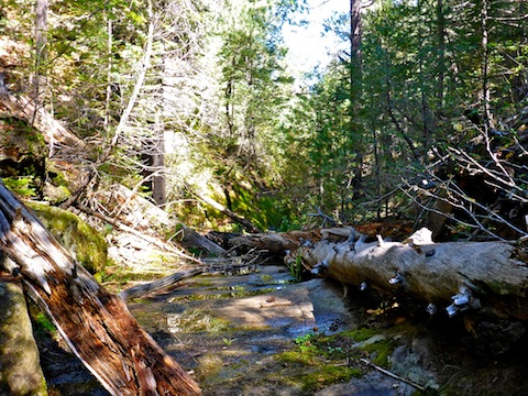
After stepping across a barb wire fence, Hi Fuller Canyon got much tighter and deeper, with more deadfall. Still, I only had to low crawl once.
Two miles into my hike, a half mile north of Hi Fuller Spring, I was brought to halt by a series of pours too high for my old ass to negotiate.
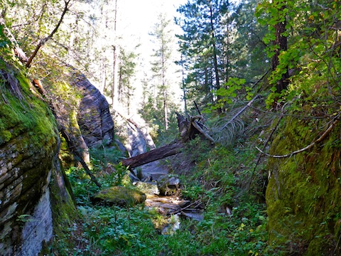
I figured I would head up a bit, to my right, then back down. I followed a game trail, but it kept going up and I did not feel like bailing to the ridge top.
I backtracked a bit, then followed a lower contour, but one still some 80 ft. above the floor of Hi Fuller Canyon, until I came to a draw that had a slope less than vertical. But I could not access the draw directly. 🤔
It took me about 10 minutes to figure a route down the draw. The first step was to butt scootch along a small ledge for about 20 ft., to where I could step into the draw, rather than jump 10 ft. down. Once I was in the undergrowth choked draw, I had to step very carefully, to avoid catching a foot, while my momentum was going forward, causing a 80 ft. tumble. Plus, no way of knowing what holes or rocks might be under the weeds and vines, waiting to break my ankle. 📱🛰🚁
I made it. Thankfully, there was no poison ivy.
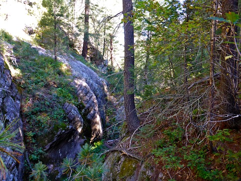
I amused myself for a minute, testing the deepness of the pool below the pour, by throwing rocks in it.
The junction with East Miller Canyon, and thus the end of Hi Fuller Canyon was only another 100 yds on. I took a break at a good sitting log, then contemplated my options.
I had no desire to bushwhack back up Hi Fuller Canyon to the unnamed side draw that had been my intended egress point. I looked at the surrounding bluffs and it seemed like there were steep, but viable, routes west up to FR 320 and east up to FR 501. I opted to head east.
Like my egress from Middle Miller Canyon back in August, I found a game trail up a steep draw. It was not nearly as steep, nor as choked with undergrowth, as my pour bypass, so I made the top in only nine minutes.
From there, it was a quick cruise back along FR 501, past a couple of 5th wheel camp sites, to the trailhead.
Directions: From Phoenix, head north on AZ-87, the Beeline Highway, through Payson, Pine and Strawberry. (Alternately, take I-17 north, then AZ-260 east.) 2.6 miles north of AZ-260, turn right onto Rim Rd. / FR 300. Rim Rd. is dirt and, at its western end, twisty and very bumpy. I would not do it in a car. In just over 11 miles, turn left on FR 123. In 200 yds., make the next left onto FR 141H. In 5.3 miles, turn right onto FR 501. Park immediately after splitting left onto FR 501A.
GPS File: Hi_Fuller_Canyon
Distance: 5.62 mi.
AEG: 508 ft.
Time: 2h 24m
Hiking Video
Hiking Hi Fuller Canyon, Mogollon Rim from Preston McMurry on Vimeo.